Ho‘okuleana – it’s an action word; it means, “to take responsibility.” We view it as our individual and collective responsibility to: Participate … rather than ignore; Prevent … rather than react and Preserve … rather than degrade. This is not really a program, it is an attitude we want people to share. The world is changing; let’s work together to change it for the better. (All Posts Copyright Peter T Young, © 2012, 2013, 2014, 2015, 2016, 2017 Hoʻokuleana LLC)
Showing posts with label Captain Cook. Show all posts
Sunday, February 22, 2015
Atooi
How do you pronounce Atooi … and Kauai?
Cook’s Journal, the first writing of the Hawaiian words, generally notes the Island of Kauai as ‘Atooi.’ Others writers note Atooi, but also associate ‘Kawai’ and ‘Kauhai.’
Cook spelled the other Island names: Oreehoua (Lehua,) Tahoora (Kaʻula,) Oneeheow (Niʻihau,) Woahoo (Oʻahu,) Morotoi or Morokoi (Molokai,) Mowee (Maui) and Owhyhee (Hawaiʻi.)
Given how Cook spelled other Island names, it appears the Island name of ‘Atooi’ (Kauai) sounded like ‘ahh too eye.’
Hiram Bingham notes the Island name in his explanation of his understanding of the Hawaiian language suggested “Corrected in English” for the name as “Cowʻ-eyeʻ” and the “New” spelling as “Kauʻ aiʻ”.
Click HERE for the full post and images.
Friday, February 13, 2015
A Connecticut Yankee in Captain Cook’s Crew
John Ledyard, the son of a ship captain, was born in Groton Connecticut in 1751. He headed to sea. He joined Captain Cook on the Resolution and Discovery (the only American on Board;) in Tahiti, he is reportedly the first Westerner to be tattooed – with “Otaheite marks on my hands”.
With cold weather setting in, Cook decided to head to the Sandwich Islands for winter quarters. He was there when Cook was killed. A final journey, begun in June 1788, would be Ledyard's last. On an expedition in Africa, he suffered a digestive ailment that eventually claimed his life in January 1789. John Ledyard was 38 years old.
Click HERE for the full post.
Monday, January 19, 2015
Scurvy
"(A) sailor's diet consisted of salted fish and meat, dried vegetables, weeviled biscuits and rancid oils, cheese, and butter. ... The caloric content - estimated at 2,500-3,000 calories - was adequate, but the diet was sorely deficient in vitamins."
"In the absence of vitamin C, rampant scurvy became responsible for thousands of sailors' deaths and disabilities. On long voyages, nearly three-quarters of a ship's crew was likely to be unable to sail because of this deficiency." (Cuppage)
Scurvy (derived from the Latin name scorbutus) is a disease that occurs when you have a severe lack of vitamin C (ascorbic acid) in your diet. Scurvy causes general weakness, anemia, gum disease and skin hemorrhages. (nih-gov)
It is a gradually debilitating disease that destroys the body's connecting tissues, causing lethargy, blotchy skin, rotting gums and teeth, and reopening of old wounds or healed fractured bones. If not treated, scurvy leads to death.
Scurvy was at one time common among sailors, pirates and others aboard ships at sea longer than perishable fruits and vegetables could be stored (subsisting instead only on cured and salted meats and dried grains) and by soldiers similarly deprived of these foods for extended periods.
“The plague of the sea,” killed over an estimated 2-million sailors during the Age of Sail. Far more naval personnel died from scurvy than all other diseases combined, including deaths from combat, storms, disasters and shipwrecks. (Captain Cook Society)
In the early years, its causes were imperfectly diagnosed according to prevailing medical theories and assumptions. Mandated treatments prescribed included bleeding and a host of concoctions, some of which would now be considered potentially harmful (e.g. mercury and sulphuric acid.)
One of Captain James Cook’s most important discoveries during his voyages was actually about food. Cook realized that there were certain foods that, if eaten, prevented scurvy. (Mariners Museum)
Cook experimented with a variety of alternatives to combat scurvy. Bown writes, Cook used "a regiment of cleanliness, fresh air, and an antiscorbitic diet." (Captain Cook Society)
Cook took two major steps to change the diet of his crew. First, every time the ships stopped anywhere that grew fresh fruit and vegetables, he bought some to feed to the crew. However, because there were sometimes weeks between stops, and fruit and vegetables would rot in that time, he had to have another plan. (Mariners Museum)
Cook "eagerly embraced" the Admiralty's tactics by stocking on board a range of antiscorbitics such as sauerkraut, wort of malt, carrot marmalade, and concentrated (robs) of orange and lemon juice, among other treatments.
He encouraged naturalists who sailed on voyages to identify edible plants to fight scurvy. Fresh vegetables and fruits were added to the ships' food supply (e.g., scurvy grass, wild celery, the Kerguelen Cabbage.)
After Cook ordered sauerkraut served daily at the "Cabbin Table", the once-reluctant sailors ate it as well and "murmurings" against it ceased. Cook's experiments with "rigid enforcement of diet and cleanliness" led to "unheard of accomplishment." (Captain Cook Society)
Cook’s crew was out to sea for a longer period of time than any sailors before them. And yet, not one of Cook’s sailors died of scurvy. This means that Cook proved that certain foods could prevent scurvy, and smart sea captains after him followed his example and took sauerkraut, fruit and vegetables on their voyages. (Mariners Museum)
Cook's crew first sighted the Hawaiian Islands in the dawn hours of January 18, 1778. His two ships, the HMS Resolution and the HMS Discovery, were kept at bay by the weather until the next day when they approached Kaua‘i’s southeast coast.
On the afternoon of January 19, native Hawaiians in canoes paddled out to meet Cook’s ships, and so began Hawai‘i’s contact with Westerners. The Hawaiians traded fish and sweet potatoes for pieces of iron and brass that were lowered down from Cook’s ships to the Hawaiians’ canoes.
The first written record of sugarcane in Hawaiʻi came from Captain James Cook, at the time he made initial contact with the Islands. On January 19, 1778, of Kauaʻi, he notes, "We saw no wood, but what was up in the interior part of the island, except a few trees about the villages; near which, also, we could observe several plantations of plantains and sugar-canes." (Cook)
Cook notes that sugar was cultivated, "The potatoe fields, and spots of sugar-canes, or plantains, in the higher grounds, are planted with the same regularity; and always in some determinate figure; generally as a square or oblong". (Cook)
It appears Cook was the first outsider to put sugarcane to use. One of his tools in his fight against scurvy was beer.
On December 7, 1778 he notes, "Having procured a quantity of sugar cane; and having, upon a trial, made but a few days before, found that a strong decoction of it produced a very palatable beer, I ordered some more to be brewed, for our general use."
"A few hops, of which we had some on board, improved it much. It has the taste of new malt beer; and I believe no one will doubt of its being very wholesome. And yet my inconsiderate crew alleged that it was injurious to their health." (Cook)
"I gave myself no trouble, either by exerting authority, or by having recourse to persuasion, to prevail upon them to drink it; knowing that there was no danger of the scurvy, so long as we could get a plentiful supply of other vegetables".
"But, that I might not be disappointed in my views, I gave orders that no grog should be served in either ship. I myself, and the officers, continued to make use of this sugarcane beer, whenever we could get materials for brewing it." (Cook, 1778) The image shows Captain Cook.
Follow Peter T Young on Facebook
Follow Peter T Young on Google+
Follow Peter T Young on LinkedIn
© 2015 Hoʻokuleana LLC
Labels:
Beer,
Captain Cook,
Grog,
Hawaii,
Resolution,
Scurvy,
Whaling
Saturday, January 10, 2015
Kōnane
Lawe ʻili keokeo, paʻani, ka ʻeleʻele
Removing the whites is playing with the blacks
It starts with a papamū, a generally rectangular flat stone whose surface is marked with shallow pits in regular order and of considerable number. Later more mobile boards were used.
The center of the board was called piko (navel) and frequently marked with an inset human molar; sometimes every position had an inset tooth (or a chicken or human bone.) The row along the borders of the board was termed kakaʻi. (Ernst)
“They have a game somewhat resembling draughts (checkers,) but more complicated. It is played upon a board about twenty-two inches by fourteen, painted black, with white spots, on which the men are placed; these consist of black and white pebbles, eighteen upon each side, and the game is won by the capture of the adversaries pieces.”
“Tamaahmaah (Kamehameha) excels at this game. I have seen him sit for hours playing with his chiefs, giving an occasional smile, but without uttering a word. I could not play, but William Moxely, who understood it well, told me that he had seen none who could beat the king.” (Campbell)
Captain James Cook also noted Konane in his journal. “It is very remarkable, that the people of these islands are great gamblers. They have a game very much like our draughts; but, if one may judge from the number of squares, it is much more intricate.”
“The board is about two feet long, and is divided into two hundred and thirty-eight squares, of which there are fourteen in a row, and they make use of black and white pebbles, which they move from square to square.” (Cook)
Kōnane boards do not follow any established pattern in size and range from 6x6 boards to well over 14x14 boards. (Some suggest even larger boards are used.)
To begin the game, the first player (black) must remove one of their pieces, either the center piece, one laterally next to it or one at a corner. The second player (white) now removes a piece of their own, adjacent to the space created by black’s first move.
Then, the players take turns making moves. A player moves a stone of his color by jumping it over a horizontally or vertically (not diagonally) adjacent stone of the opposite color, into an empty space. Stones so jumped are captured, and removed from play. Thereafter players take turns making moves on the board.
A stone may make multiple successive jumps in a single move, as long as they are in a straight line; no turns are allowed within a single move. The winner of the game is the last player able to make a move.
Kōnane figures in the saga of Lonoikamakahiki, a great chief credited with creating the first kahili and instituting the Makahiki games.
In a fit of jealous rage over rumors that she had been unfaithful, he killed his wife during a game of kōnane by beating her over the head with the heavy board. Later learning of her steadfastness, he was crazed with grief, but eventually nursed back to health by a faithful retainer. (Yuen)
King Kalākaua and his Queen Kapiʻolani were experts at kōnane, and it is well known that the goddess Pele did not refuse to play the game with the demigod Kamapuaʻa. (Brigham)
An alternative name for kōnane was mū, and for the board, papamū. Brigham notes that mū was the name of the official who captured men for sacrifice or for judicial punishment and suggests this name was adopted for the game. (Ernst)
The image shows a papamū stone and Kōnane board at the Puʻuhonua O Hōnaunau National Historical Park (NPS.) In addition, I have added some other images in a folder of like name in the Photos section on my Facebook and Google+ pages.
Follow Peter T Young on Facebook
Follow Peter T Young on Google+
Follow Peter T Young on LinkedIn
© 2015 Hoʻokuleana LLC
Wednesday, November 26, 2014
James Hay Wodehouse
James Hay Wodehouse was born on April 23, 1824. He was the second son of Charles Nourse Wodehouse (Archdeacon of Norwich) and Lady Dulcibella Jane Hay. He married Annette Fanny Massey, daughter of William Massey, on January 19, 1861.
Wodehouse was private secretary to George Grey (Governor of New Zealand) in 1851; on November 5, 1860, it was announced, “The Queen has been graciously pleased to appoint Major James Hay Wodehouse to be her Majesty's consul in the Society or Leeward Islands in the Pacific Ocean.” (London Daily News, November 24, 1860)
On June 21, 1866, “The Queen has been graciously pleased to appoint James Hay Wodehouse, Esq … to be Her Majesty's Commissioner and Consul-General in the Sandwich Islands.” (British Bulletins, 1866)
A retired British Army Major, Wodehouse took up his duties and thereafter worked diligently to protect British interests during a long career. (Andrade) “Minister Wodehouse represented the British Governmental the Hawaiian court for over twenty-five years with great credit.” (San Francisco Call, August 11, 1895)
These were tumultuous times in the Islands. Through several monarchs, the issue of independence / annexation and takeover by others were part of the ongoing discussions.
“About the end of 1867, Queen Emma, in a conversation with British Commissioner JH Wodehouse, assured him ‘that with a few exceptions, all the natives were opposed to annexation.’” (Daws)
“Many times, Kamehameha V stated his firm resolve to maintain the independence of his kingdom, and there is no good reason to doubt the sincerity of these declarations. British Commissioner Wodehouse reported a conversation with the king in which the latter expressed ‘his determination to resist any project for the annexation of his Islands to the United States.’” (Daws)
On January 17, 1893, Queen Lili`uokalani yielded her authority to the US government. In 1895, an abortive attempt by Hawaiian royalists to restore Queen Liliʻuokalani to power resulted in the Queen’s arrest.
Convicted of having knowledge of a royalist plot, “at two o'clock on the afternoon of the 27th of February I was again called into court, and sentence passed upon me … a fine of $5,000, and imprisonment at hard labor for five years.” (Queen Liliʻuokalani) The sentence was commuted to imprisonment in an upstairs apartment in ʻIolani Palace.
“(Wodehouse) was strongly opposed to the revolution, and made himself obnoxious to the Provisional Government, who came to regard the British legation as the chief center of royalist intrigue.” (San Francisco Call, August 11, 1895)
The British Government, having recognized the Hawaiian Republic, recalled Wodehouse and appointed Mr Hawes British commissioner and consul general. Major Wodehouse, on his departure, neglected to pay an official farewell to the Dole Government, and proposed to take leave of the ex-Queen, imprisoned in the palace. (Appletons’, 1895)
“Previous to Mr Wodehouse's departure from Honolulu he requested a parting interview with ex-Queen Liliʻuokalani, but the request received a positive refusal. The reason assigned was that Mr Wodehouse still held an official character of which he could not divest himself, so as to render his visit to the former Queen one merely of friendship.” (San Francisco Call, August 11, 1895)
“(A)n open letter of Mrs Wodehouse to the ex-Queen had been returned to the writer because it was addressed to ‘Her Majesty.’ The denial of intercourse in the case of the British Minister is an exception to a very considerable degree of the freedom usually allowed to Mrs Dominis in seeing her friends. (San Francisco Call, August 11, 1895)
Wodehouse had other reasons for desiring to be relieved of his duties at this time. He had been in Hawaiʻi for 15-years without any leave, was not in good health and wished to return to England to spend his last years. The British government accordingly granted him leave to return to England. (Andrade) Wodehouse died in England on July 13, 1911.
Here’s a little Wodehouse side note: A malfunctioning chronometer put the British sailing ship Dunnottar Castle off course and onto the reef at Kure atoll. Seven of the crew members, including its Chief Officer, took one of the surviving boats and sailed, for 52 days, to Kauaʻi. Upon being informed of the tragedy, the British Commissioner in Honolulu organized a rescue mission. (HawaiianAtolls)
Wodehouse decided to send a ship for the remaining crew. Suspecting that the British might use the occasion to annex the island, the Hawaiian Government shared the expedition expenses and instructed Commissioner James Boyd to take formal possession of Kure. On September 20, 1886 Boyd took possession of the island, then-called Mokupāpapa, for the Hawaiian government. (PMNM)
The rescue mission came back to Honolulu with the same amount of people it had sailed out with. No survivors were found on the atoll, except for two fox terriers and a retriever. All of the survivors had been picked up earlier by a passing vessel and were on route to Chile. (HawaiianAtolls)
Here’s another side note, relating to one of Wodehouse’s sons, ‘Hay.’ On July 30, 1889, Robert William Wilcox led a rebellion to restore the rights of the monarchy, two years after the Bayonet Constitution of 1887 left King Kalākaua a mere figurehead.
“The day was won, they say, by a base ball (catcher,) who threw dynamite bombs into the bungalow that formed the headquarters of the insurgents and brought them to terms quicker than rifle or cannon shot.”
“Bombs were made, but it was found that there were no guns to fire them. It was a long throw, and in their dilemma the King's guards secured the services of Haywood (Wodehouse,) (catcher) of the Honolulu Base Ball Club.”
“(Wodehouse) took up his position in the Coney Island building, just across a narrow lane, and overlooking the bungalow. No attack was expected from that quarter, and there was nothing to disturb the bomb thrower. (Wodehouse) stood for a moment with a bomb in his hand as though he were in the box waiting for a batsman. He had to throw over a house to reach the bungalow, which he could not see.”
“The first bomb went sailing over the wall, made a down curve and struck the side of the bungalow about a foot from the roof … The bomb had reached them and hurt a number of the insurgents. (Wodehouse) coolly picked out another bomb. Then he took a step back, made a half turn and sent it whizzing. It landed on the roof … He threw one more bomb and Wilcox came out and surrendered." (The Sporting Life, October 16, 1889)
Here’s one more … The unveiling of the Captain Cook monument in Kealakekua Bay took place on November 14, 1874. Credit for it is given to Princess Likelike (sister of King Kalākaua and Queen Liliʻuokalani, and mother of Princess Kaʻiulani (who sold the land for $1 on January 26, 1877 to be held in trust for the monument in memory of Captain Cook)) and British Commissioner Wodehouse.
“The erection of a suitable and durable monument to the memory of Captain James Cook has been often proposed and more than once attempted, but has now been happily accomplished under the direction of Mr Wodehouse, the British Commissioner, with the cooperation of Captain Cator of HMS ship Scout, who kindly conveyed the architect and his men and materials to the spot in Kealakekua Bay, where the circumnavigator fell, and where now, nearly a century later, a fitting monument is at last dedicated to his memory.”
“It is a plain obelisk, standing on a square base, the whole being twenty-seven feet in height, and constructed throughout of a concrete composed of carefully screened pebbles and cement, similar to tie material of which the fine public buildings in this city are built. It stands on an artificially leveled platform of lava only a few feet distant from and above the highwater mark, and fifteen or twenty yards from the shore or lava slab on which the great seaman stood when struck down.”
“The site is thus the most suitable that could have been chosen, and is the gift of Princess Likelike, wife of Hon. AS Cleghorn. The expense of the erection is partly borne by subscribers in England…” (Hawaiian Gazette, November 25, 1874)
The image shows James Hay Wodehouse. (Kuykendall) In addition, I have added other images in a folder of like name in the Photos section on my Facebook and Google+ pages.
Follow Peter T Young on Facebook
Follow Peter T Young on Google+
Follow Peter T Young on LinkedIn
© 2014 Hoʻokuleana LLC
Monday, September 8, 2014
Naukane
During Captain Cookʻs visit to Hawaiʻi on his third voyage of exploration in 1779, then-Lieutenant King (later Captain) noted, “During the following night, the cutter belonging to the Discovery was stolen …”
“This irritated captain Cook, and he gave orders to stop all the canoes that should attempt to leave the bay, intending to seize and destroy them, if he could not recover the cutter by fair means.” (Captain King's Journal)
“The natives now collected in vast numbers along the shore, and began to throng round captain Cook”. Shortly after, “Captain Cook, the last time he was seen distinctly, was standing at the water's edge”.
“… he was desirous of preventing any farther bloodshed … whilst he faced the natives, none of them had offered him any violence, but having turned about to give his orders to those in the boats, he was stabbed in the back”. Cook was killed. (Captain King's Journal)
One of the Hawaiians at the scene was Naukane, son of Kamanawa (Kamehameha’s uncle and one of his closest allies – Kamanawa (left) and Kameʻeiamoku, his twin brother (right) were later memorialized on the Hawaiʻi coat of arms.) (Kittelson)
When Kamehameha moved his Royal Center to Honolulu, his chiefs came with him. Naukane, then in his early twenties, accompanied his father and probably became involved in royal court life. However, fascinated by the growing number of ships calling in the islands, Naukane looked to the sea. (Kittelson)
His chance came in February 1811, when John Jacob Astor’s ‘Tonquin,’ under the command of Captain Jonathan Thorne, called. The captain wanted to hire twenty-four of the Islanders, twelve as seamen and the remaining half to establish a post for the Pacific Fur Company on the Columbia River.
This was the first large group of Hawaiians to come to America. The king appointed Naukane to go with them as a royal observer. (Duncan)
Because Naukane resembled one of the Americans, he became known as John Coxe and retained the name throughout his long and colorful life in the Pacific Northwest (he also went by John Cox and Edward Coxe, or, simply Coxe.) (Duncan)
The Tonquin reached the mouth of the Columbia in March; after a few days looking, they selected a site and by the end of May they had completed Fort Astoria. It was the first American-owned settlement on the Pacific coast of what was to become the United States.
Astor planned the post to grow into a permanent settlement, with plans to develop a large trade ring that included New York, the Pacific Coast, Russian Alaska, Hawaiʻi and China. The furs collected in the northwest and Alaska, would be shipped to China and exchanged for porcelain, silk and other cloth, and spices that would be brought back, via Hawaii to New York.
Other operators had other posts. In the summer of 1810, Jacques-Raphaël Finlay (Jaco Finley) of the North West Company built Spokane House at the junction of the Spokane and Little Spokane rivers.
Shortly after arriving in the northwest, Coxe started working for Canadian David Thompson of the North West Company. Coxe later spent the winter of 1811-1812 at Spokane House with Finlay. On those expeditions, Coxe became the first Hawaiian to visit the inland Northwest.
Coxe accompanied Thompson “across the Rocky Mountains from western Montana and in the long trail to Fort William on Lake Superior. … John Coxe also took the trail east from Fort William but his road led to Quebec, where he created a sensation with his stories of Hawaiʻi and his demonstrations of Polynesian dance steps.” (Taylor)
By 1813, Fort Astoria and all other assets in the area were sold to the North West Company – they renamed it Fort George. Coxe continued to work there until August, 1814, when all of the Hawaiians at Fort George were sent back to the Islands.
Comfortable with the service from the Hawaiians, in 1817, North West sent a ship “to bring as many of the Sandwich Islanders to the Columbia river as we could conveniently accommodate.” (Corney)
(In 1821, the Hudson’s Bay Company combined with the North West Company, and the post name was changed back to Fort Spokane.)
After he returned to Honolulu in 1815, Coxe probably reverted to his native name, Naukane. He was well received by Kamehameha.
Not only was Naukane the son of one of Kamehameha’s closest advisors, and a member of Liholiho’s entourage, but he had traveled widely. Kamehameha I died in 1819 and Naukane rose in stature when Liholiho ascended the throne. (Kittelson)
Naukane’s expeditions did not end on the American continent. Because of his familiarity with western ways (with travels to America, Europe & South America) and his personal ties, when Liholiho departed on November 27, 1823 to England aboard the L'Aigle to discuss the future of his Islands with George IV, Naukane accompanied the King.
The King Kamehameha II and Queen Kamāmalu died of measles in July 1824; apparently Naukane’s travels had built up his immunity, for he was hardly bothered by measles.
King George IV held an audience for the remaining Hawaiians at Windsor Castle on September 11; Coxe was present. The bodies of Liholiho and his queen were returned to Hawaii aboard the frigate Blonde captained by Lord Byron.
With the King dead, Naukane no longer was bound, and he immediately offered his services to the Hudson’s Bay Company and returned to the Northwest. He was only one of approximately thirty-five Islanders working for the company by 1825. (Duncan)
The firm’s base of operations had been transferred from Fort Spokane to a new site farther inland, Fort Vancouver. Coxe worked for a few more years; then the company retired him and gave him a plot of land two miles below the fort. (Kittelson)
Naukane died February 2, 1850. The vast plain between Fort Vancouver and the Columbia became the Hawaiian’s memorial - Coxe’s Plain … “A couple of miles below the fort (Vancouver) there were luxuriant meadows of great extent.”
“A portion of these bore at that time the name of Coxe’s Plain, a name I think which it still continues to bear. Old Coxe, a native of the Sandwich Islands and a very original character, was the swine-herd and had his residence there among the oaks which dotted the verge of the plain.” (Anderson; Barry)
The image shows Naukane. In addition, I have added other images in a folder of like name in the Photos section on my Facebook and Google+ pages.
Follow Peter T Young on Facebook
Follow Peter T Young on Google+
Follow Peter T Young on LinkedIn
© 2014 Hoʻokuleana LLC
Tuesday, August 19, 2014
Early Brew Crew
Beer is produced by the saccharification (breaking into sugars) of starch and fermentation of the resulting sugar. There are eight basic steps to the standard commercial brewing process: milling, mashing, wort separation, boiling, chilling, fermenting, conditioning and packaging. (Barth)
Journal entries show Captain James Cook was the first to make beer in the Islands. On December 7, 1778 he notes, “Having procured a quantity of sugar cane; and having, upon a trial, made but a few days before, found that a strong decoction of it produced a very palatable beer, I ordered some more to be brewed, for our general use.”
“A few hops, of which we had some on board, improved it much. It has the taste of new malt beer; and I believe no one will doubt of its being very wholesome. And yet my inconsiderate crew alleged that it was injurious to their health.” (Cook)
While the crew “would (not) even so much as taste it”, Cook “gave orders that no grog should be served ... (he) and the officers, continued to make use of this sugarcane beer, whenever (they) could get materials for brewing it.” (Cook)
I realize some purists might suggest beer needs cereal grain to be brewed, and sugar is not a grain. However, beer, ultimately, is the fermentation of sugar. (BTW, starch is a primary product of photosynthesis, and is found in sugarcane stalks. (Figueira))
Other early beer references show experiences with the brew. On June 29, 1807, Iselin notes, “Went on shore with some Englishmen, etc., who took us to their houses, where they displayed beer and a kind of gin, a spirituous liquor distilled of the tea root (ʻōkolehao,) said to be drank freely in the Isles.” (Isaac Iselin)
For early indications of new plants and production from those plants in the Islands, most attention turn to Don Francisco de Paula Marin. Marin was a Spaniard who arrived in the Hawaiian Islands in 1793 or 1794 (at about the age of 20.)
His knowledge of Western military weapons brought him to the attention of Kamehameha, who was engaged in the conquest of O‘ahu. Marin almost immediately became a trusted advisor to Kamehameha I.
Marin was responsible for introducing and cultivating many of the plants commonly associated with the Islands. And, he is reportedly the first Island resident to brew beer. His journal entry for February 2, 1812 recorded the making of "a barrel of beer." On December 7, 1815, he wrote, “This day I made a little oil and a barrel of beer for Captain Tela (Tyler.)” (Schmitt)
We even see some references to beer (brewing and drinking) in missionary journals. On November 19-20, 1824, missionary Elisha Loomis notes, “Yesterday and today I have been engaged in making beer and vinegar from a root called tee, which grows plentifully in these islands. It is the most sweet of any vegetable I ever tasted. The juice is nearly as sweet as molasses.”
On October 31, 1832, Clarissa Armstrong (wife of Reverend Richard Armstrong) noted, “Capt. Brayton has given me a little beer cask - it holds 6 quarts - Nothing could have been more acceptable. I wanted to ask you for one, but did not like to. O how kind providence has been & is to us, in supplying our wants. The board have sent out hops - & I have some beer now a working. I should like to give you a drink.”
On July 24, 1836, Clarissa Armstrong notes (during an illness:) “We had a bottle of wine of which I drank … All the nourishment I took after leaving Honolulu til we reached Wailuku was two biscuit about the size of small crackers, & a bit of dried beef. Drinks were my nourishment. Limes grow at Oahu & I obtained some for the voyage, which furnished me pleasant drink. Also a little beer which I had made.”
Hawaiʻi’s first full-scale brewery appeared in 1854. From April 15 to October 21, 1854, The Polynesian carried a weekly one-column advertisement headed “Honolulu Brewery.-Genuine Beer.” (Schmitt)
The copy continued: “Brewry in Honolulu, Fort street, opposite the French Hotel, are now prepared to supply families, hotels, boarding houses and bar rooms, in bottles or in kegs. This Beer is made of barley and hops only, contains no alcohol, nor any ingredient whatever injurious to health, can be recommended to the public as the best and most wholesome beverage ever made on these islands, and we hope, therefore, to obtain the favor of public patronage. All orders will be punctually attended to. Captains and passengers will be accommodated at the shortest notice. JJ Bischoff L Co (Polynesian, September 30, 1854)
They later changed the ad, and dropped the “no alcohol” reference, “Honolulu Brewery Malt Beer. The undersigned having established a Brewery in Honolulu, Fort St., opposite the French Hotel, are now prepared to supply families, hotels, boarding houses and bar rooms, in kegs or in bottles. All orders will be punctually attended to. Captains and passengers will be accommodated at the shortest notice. JJ Bischoff & Co. (Polynesian, August 4, 1855)
Willard Francis and Thos. Warren started Hawaiian Brewery in March 1865; apparently the partnership didn’t last long. On February 10, 1866, Francis was advertising the brewery for sale, noting that he intended to leave the Islands. At the same time, Warren was advertising for “a No. 1 Brewer” for the Oʻahu Brewery. (PCA, Feb. 10, 1866)
Other breweries followed this initial effort. Gilbert Waller National Brewery Co. in Kalihi produced steam beer from January 1888 until 1893 or thereabouts. (Schmitt)
Then came one of Hawaiʻi’s notable beers, Primo, that started production on February 13, 1901. “The Honolulu Brewing and Malting Co Ltd will deliver their Primo lager either in kegs or bottled by July 1st. Orders received will be promptly filled.” (Hawaiian Star, June 27, 1901)
Another paper that day noted an early ‘Buy Local’ marketing theme, “The building up of home industries made the United States what it is today. The Honolulu Brewing and Malting Co have a home production ‘Primo Lager Beer’ why not order some when it is the equal of any beer brewed?” (Honolulu Republican, June 27, 1901)
Primo also touted the apparent health benefits of drinking beer, “Every doctor knows how beer benefits. If you need more strength or vitality, he will prescribe it. For run-down, nervous people, there is no better tonic and nutrient than a glass of good Primo Beer with meals. Primo Beer, the best tonic.” The brewery was later renamed Hawaiʻi Brewing Co.
The first American beer to be marketed in an aluminum can was Primo, in October 1958. The 11-ounce “Shiny Steiny,” developed by the Hawaiʻi Brewing Corp with the help of Kaiser, was heavily promoted but failed to achieve popularity, and it was eventually withdrawn. (Schmitt)
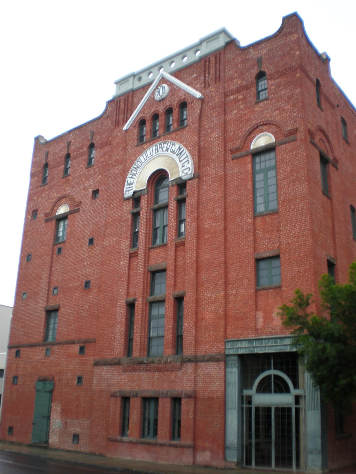
A lasting legacy of the early brew crew is the Royal Brewery on Queen Street. It was built in 1899 to the specifications of the Honolulu Brewing and Malting Company. It was constructed from materials shipped in from San Francisco and New York in 1899-1900 and was the original home of Primo. (They stopped brewing beer there in 1960.)
The image shows The Royal Brewery – former home to Honolulu Brewing and Malting Co Ltd (later Hawaiʻi Brewing Co) and initial home to Primo. In addition, I have added some other images in a folder of like name in the Photos section on my Facebook and Google+ pages.
Follow Peter T Young on Facebook
Follow Peter T Young on Google+
Follow Peter T Young on LinkedIn
© 2014 Hoʻokuleana LLC
Saturday, May 24, 2014
Portlock
Nathaniel Portlock was born in Norfolk, Virginia in about 1748. At about the age of 24, he entered the Royal Navy as an able seaman on the St Albans.
On March 30, 1776, he served as master’s mate on Captain James Cook's third Pacific voyage aboard the Discovery (Cook’s last voyage, Cook was killed in Kealakekua Bay on February 14, 1779.) Portlock was transferred to the Resolution, also on the expedition, in August 1779.
In 1785, a group of London merchants formed the "King George's Sound Co" (also known as Richard Cadman Etches and Company,) for the purpose of carrying on the fur trade from the western coast of America to China, bringing home cargoes of tea from Canton for the East India Company. They bought two boats; Portlock and George Dixon were selected to sail them.
That year, the two traveled to the North Pacific. Portlock commanded the 1785-1788 expedition from the ship King George, while Dixon captained the Queen Charlotte. The purpose of the expedition was to investigate the potential of the Alaskan fur trade and to resume Cook’s search for a Northwest Passage through the continent.
The pair left England on August 29, 1785, and took nearly a year to reach Alaska, rounding Cape Horn and touching at Hawaiʻi on the way. During the course of their 3-year expedition, they made three trips to Hawaiʻi, first arriving off the coast of Kaʻū, May 24, 1786.
(At about the same time, La Perouse, with the two frigates, La Boussole and L'Astrolabe, touched at Honuaʻula, East Maui, May 28, 1786.)
While in the Islands, Portlock named Oʻahu’s prominent landmark "Point Rose" (Lēʻahi (Diamond Head)) in honor of the secretary of the British treasury.
A favorite anchorage on Oʻahu for Portlock was at Maunalua Bay, between Koko Point and Diamond Head (which Portlock named King George's Bay.)
Maunalua was thought to be well-populated in ancient times. Maunalua was known for its offshore fishing resources, a large fishpond, and sweet potato cultivation. Taro was farmed in wet areas, sweet potato was grown in the drier regions and a series of fishing villages lined the coast. (McElroy)
In June 1786, Portlock remained four days, buying fresh water by the calabash full, at the rate of a sixpenny nail for a two-gallon calabash full, and in this way obtained over thirty tons of water. Kahekili, the King, who was then residing at Waikiki, sent Portlock and Dixon presents, but did not come on board. (Thrum)
While anchored in Maunalua Bay, Portlock reported:
"Soon after our arrival, several canoes came off and brought a few cocoa-nuts and plantains, some sugar cane and sweet root; in return for which we gave them small pieces of iron and a few trinkets."
"The old man (a kahuna) informed me, that his (Kahekili's) residence was in a bay around the West point (Black Point), and importuned me very much to carry ships there, as that place, he said, afforded many fine hogs and vegetables.”
“Indeed, I had some reason to think that the inhabitants on that part of the island were more numerous than in King George's Bay (Maunalua Bay), as I observed most of the double canoes came round the West Point ..."
"I determined to keep my present situation, it being in many respects an eligible one; for we hitherto had been favored with a most refreshing sea breeze, which blows over the low land and vallies being in a high state of cultivation, and crowded with plantations of taro, sweet potatoes, sugar cane, &c., interspersed with a great number of cocoa-nut trees, which renders the prospect truly delightful."
Finally, Portlock and Dixon headed separately for Macao (near Canton, People’s Republic of China,) traded their furs and both ships sailed for England with cargoes of tea belonging to the East India Company.
About this time, September 17, 1788, the first American ships made their appearance in Nootka Sound (Columbia.) Fitted out in Boston in August 1787, for several years they were engaged in the fur trade between the Northwest Coast and China, touching at the Hawaiian Islands to replenish their stocks and water.
Returning to service in the navy, Portlock was appointed to command the brig Assistant, in which he accompanied Captain William Bligh in 1791 on his second attempt to transport bread-fruit plants from Tahiti to the West Indies. (Bligh’s first attempt to gather breadfruit trees from Tahiti and take them to Jamaica ended in mutiny (April 28, 1789) on the Bounty.)
When they returned, Portlock was promoted commander. On September 28, 1799, he was advanced to captain, but does not appear to have had further employment at sea, perhaps owing to ill health. He died on September 12, 1817 in Greenwich Hospital.
In 1936, when landowner Bishop Estate planned a subdivision on its property at Maunalua Bay, estate Trustee Alfred Francis Judd named the subdivision after Portlock (who 150-years before, had anchored just off-shore.) (Clark)
The image shows surfing at Portlock, Maunalua Bay (in the early days.) In addition, I have added others similar images in a folder of like name in the Photos section on my Facebook and Google+ pages.
Follow Peter T Young on Facebook
Follow Peter T Young on Google+
Follow Peter T Young on LinkedIn
© 2014 Hoʻokuleana LLC
Saturday, May 17, 2014
Owyhee
Some suggest the spelling was the way Captain James Cook spelled the Island chain he “discovered” in 1778, and the name of the island where he eventually died.
However, we need to remember that Cook first sighted Oʻahu on January 18, 1778. On February 2, 1778 his journal entry named the island group after his patron: “Of what number this newly-discovered Archipelago consists, must be left for future investigation. … I named the whole group the Sandwich Islands, in honour of the Earl of Sandwich.” (Cook’s Journal) (That name stuck for about 60-years, when the Hawaiian Islands replaced the Sandwich moniker.)
Likewise, in the dedication of his journals, the memorial (and in numerous references throughout) noted: “He raised himself, solely by his merit, from a very obscure birth, to the rank of Post-Captain in the royal navy, and was unfortunately killed by the savages of the of the island Owhyhee on the 14th of February, 1779; which island he had not long before discovered, when prosecuting his third voyage round the globe.”
When Captain Cook first visited the Hawaiian Islands, Hawaiian was a spoken language but not a written language. Historical accounts were passed down orally, through chants and songs. After western contact and attempts to write about Hawaiʻi, early writers tried to spell words based on the sound of the words they heard. People heard words differently, so it was not uncommon for words to be spelled differently, depending on what the writer heard.
So the origin of the specific spelling of this place(s) is not clear.
The discussion of this place relates to a river on the continent (and some places it passes that are similarly named.) There are many stories about other “Owyhee” continental place names; those are subjects of future stories – this one is about the Owyhee River. The word Owyhee is the older spelling of Hawaiʻi.
The USGS Geological Names Information Systems note an 1838 map of Oregon Territory prepared by Samuel Parker (not Hawaiʻi’s Samuel Parker) as the citation for the river’s name (by Board action of the Board of Geographic Names, the river received that “Official” name in 1959.)
The Owyhee River (a 280-mile tributary of the Snake River) has its source in northern Elko County, Nevada, flowing northward into southwestern Idaho through Owyhee County, and continuing into extreme southeastern Oregon in southern Malheur County.
So how did Hawaiʻi (Owyhee) make it to the Oregon Territory? And, why did a river receive that name?
To get there, we need to go back a bit … to 1811.
That year, the first two-dozen Kanakas (Hawaiians) were recruited to work the Pacific Northwest to support the expanding fur trading business (twelve as seamen and the remaining half to work at a proposed fur post.)
Thick, luxurious and water-repellent furs of sea mammals (from beavers, sea otters and fur seals) were highly valued in China as well as in Europe, where they were sewn into coats, hats and bed covers. Furs were mostly traded in China in exchange for tea, silks, porcelain and other Chinese goods, which were then sold in Europe and the US.
Trading ships plying between the Northwest, China and Europe would stop in Hawaiʻi to replenish their stores. Hawaiians had worked on many of the merchant ships. Most served as seamen or contract workers; others manned their outposts and built structures or farmed food for the ships’ crews and others.
As the fur trade expanded, nearly every post had had a contingent of Kanakas, who were noted for their reliability, cheerful dispositions and hard work.
This leads us to Donald Mackenzie, a brigade leader for the Canadian North West Company, who led yearlong trapping expeditions on the Snake and Columbia Rivers in the Oregon Territory.
About one-third of Mackenzie’s men on his 1818-1820 Snake River expedition were Kanakas. Mackenzie and his party wintered among the Snake Indians in 1819-1820.
Three of his Kanakas had been sent to another area to hunt beaver. When they did not return, Mackenzie sent out a search party which “found the place where they had been hunting, and where they had been murdered (believed to be by a band of Bannock Indians;) the skeleton of one of them was found, but nothing else." (Duncan)
The river in the area was thereafter known as the Owyhee (in honor of the three Hawaiians.) (Some early references also note the name as “Sandwich Island River.”)
The earliest surviving record of the name is found on a map dating to 1825, drawn by William Kittson (who was previously with Donald Mackenzie in 1819-1820.)
Then, Peter Skene Ogden, who led subsequent Snake River expeditions for the Hudson’s Bay Company in 1825-1826, noted in his journal, “Saturday, (February) 18th (1826.) Severe cold. … when we reached Sandwich Island River, so called, owing to 2 of them murdered by Snake Indians in 1819. This is a fine large river…”
Ogden later notes, “Thursday, June 15th (1826.) All along our route this day the plains were covered with women digging roots; at least 10 bushels were traded by our party; the men (Indians) all gone to join the Fort Nez Perces Indians. Reached a fork of Owyhee River.”
The Owyhee begins at its headwaters in Nevada, flows through Idaho, and crosses into southeastern Oregon, where it eventually flows into the Snake River. From the Oregon/Idaho border to the Owyhee Reservoir (formed by the Owyhee Dam), the river flows through deeply incised canyons in a remote, arid and almost unpopulated area.
Other places near or on the river received the same “Owyhee” name.
Owyhee Dam, the tallest in the world when completed in 1932, is significant as a proving ground for engineering techniques used later in construction of Hoover Dam. As construction of the Owyhee began in 1928, plans were being laid for the much larger Hoover Dam on the Colorado River; it was Hoover’s testing ground. (NPS)
The Bureau of Reclamation’s Owyhee irrigation project is the largest in Oregon, with surrounding farmland used for a combination of livestock grazing and specialty crops such as potatoes, sugar beets, onions, and alfalfa seed. (In 1984, a hydroelectric powerhouse was built just downstream from the dam.)
The first known recreation use of the river occurred in 1951, when commercial outfitter Prince Helfrich floated from Three Forks to Rome utilizing surplus World War II rubber assault rafts. Boating use remained extremely light through the 1950s and 60s.
The Bureau of Land Management (BLM) began recording recreation use in 1974, when 482 persons floated the river. By 1980, 2,000 boaters were utilizing the Owyhee and popular campsites were beginning to show the effect of recreational use. (Meyer)
In 1970 the state of Oregon designated the Owyhee River as a State Scenic Waterway. On October 19, 1984, President Reagan signed Public Law 98-494, designating 120 miles of the Owyhee River from the Oregon-Idaho boundary to the Owyhee Reservoir, excluding the Rome Valley from China Gulch to Crooked Creek, as a "Wild River" to be included in the National Wild and Scenic Rivers System.
Oh, back to the fur trappers … they didn't last long. It was the discovery of gold that brought many more people to the Owyhee. As prospectors fanned out throughout the state they eventually found their way into the Owyhee Mountain; a group discovered gold there in 1863.
The image shows a portion of William Kittson's 1825 map noting the Owyhee. (boisestate-edu) In addition, I have added other images in a folder of like name in the Photos section on my Facebook and Google+ pages.
Follow Peter T Young on Facebook
Follow Peter T Young on Google+
Follow Peter T Young on LinkedIn
© 2014 Hoʻokuleana LLC
Saturday, May 10, 2014
Circumnavigation of the World
With the impending departure of Hōkūleʻa and Hikianalia on their journey around the world “to learn, create global relationships, and explore how to care for our oceans and island earth,” (PVS) we recognize they are also following the footsteps of Hawaiʻi’s last king, Kalākaua, over a century ago in sharing the Islands with others.
“O’er land and sea I’ve made my way; To farthest Ind, and great Cathay; Reached Afric’s shores, and Europe’s strand; And met the mighty of every land.”
“And as I stood by each sovereign’s side, Who ruled his realm with a royal pride, I felt how small my sway,—and weak:— My throne based on a mere volcanic peak, Where millions do these Kings obey, Some thousands only own my sway.”
“And yet I feel that I may boast, Some good within my sea-bound coast, Richer than those of my grander peers, That I within my realm need have no fears”
“May mingle with my people without dread: No danger fear for my unguarded head, And boast a treasure, sent me from above That I have indeed, my people’s love.” (Kalākaua’s Boast, PCA)
King Kalākaua was the first ruling Monarch to tour of the world; in doing so, he made good on his motto, and motivation, proclaimed at his accession, ‘Hoʻoulu Lahui!’- (Increase the Nation!)
“Since the concert of the morning stars, or the appearance of man on the globe, sovereigns have done many great and many small things; but not one of them, even in these later days, has had the audacity or pluck to circumnavigate this little planet.” (Armstrong)
“A deep feeling of anxiety and interest pervaded the community on the eve of the departure of the King, and all classes and races strove to outvie each other in their expressions of good-will and affection, in bidding adieu to His Majesty.” (PCA)
“(T)he King goes but for the good of his people, to make the country richer by getting more capital and people to come this way. … So the King this time takes with him a Commissioner to enquire into and bring other people of brown skins here to re-people these isles.” (Kapena)
The King and others were concerned about the declining Hawaiian population in the Islands. “The King himself would be only so in name if he had no people to rule. The King will not rest until his hope of re-peopling these isles has been fulfilled.” (Kapena)
Leaving January 20, 1881 on the Oceanic and arriving back in the Islands October 29, 1881 (nine months and nine days later,) Kalākaua travelled to the US, Japan, China, Siam, Burma, India, Egypt, Italy, Belgium, Germany, Austria-Hungary, France, Spain, Portugal and the United Kingdom.
Kalākaua wanted to gain recognition for his kingdom and learn how other monarchs ruled. He believed the best way to conclude diplomatic relations with foreign countries was to understand their customs.
He met with the Emperor of Japan; General Li Hung Chang, of China; the Governor of Hong Kong, in the name of the British Queen; the King of Siam; the British Governors or Commissioners of Singapore, Penang, the Malacca Straits, and of Burma; the Vice-Regal Court of India; the Viceroy of Egypt; the King of Italy; the Pope, Holy Father in Rome; the British Queen; the King of Belgium; the Court of Emperor William of Germany; the officials of the Austrian Empire, in the absence of the Emperor; the officials of the French Republic; the officials of the Spanish Court, whose Regent was absent; the King of Portugal; and finally, the President of the United States.
For the most part, the King travelled incognito (his trip was claimed to have “no official significance.”) At times his unannounced arrivals caused some confusion (and missed opportunities to meet with leaders (who were out of town.))
However, he was greeted and handled with stately attendance. He was royally entertained and decorated with the highest orders; armies were paraded before him and banquets held in his honor.
Three white men went with him as advisers and counsellors, William N Armstrong (his Attorney General,) Colonel Charles H Judd (his Chamberlain and one of his most trustworthy friends) and a personal attendant/valet (a German known as ‘Robert.’)
Armstrong and Judd were sons of American missionaries to the Islands – and the only companions of the King on the voyage. (Armstrong)
Armstrong and Judd were Kalākaua’s schoolmates at the Chiefs' Children's School in 1849. (Marumoto) “Thirty years afterward, and after three of our schoolmates had become kings and had died (Kamehameha IV & V and Lunalio) and two of them had become queens (Emma and Liliʻuokalani,) it so happened that Kalākaua ascended the throne, and with his two old schoolmates began his royal tour.” (Armstrong)
During the trip, Armstrong was given the additional titles of Minister of State and Royal Commissioner of Immigration. The title of Minister of State was given in order to place Armstrong in the same rank as the cabinet ministers of foreign sovereigns. (Marumoto)
One striking incident occurred while the King was being entertained by the Khedive of Egypt at Alexandria. The royal party, during the reception, was brought out on the balcony of the palace to look out over the harbor. And while they were standing there, an attaché pointed out to King Kalākaua an old hulk used for receiving coal.
The hulk was all that was left of the Resolution, the ship in which Captain Cook ‘discovered’ the Hawaiian Islands. The King said: “Let us drink a toast to the old ship.” The wine was brought, and on the grand balcony, with the harbour lighted with rockets and lanterns, the King raised his glass and said, “Here's to the ‘Resolution.’” (Armstrong)
At the end of his trip Kalākaua declared that he had found nothing in the civilized world of which his nation stood in need with the exception of some well bred horses and sheep. He said that he found his own subjects to be better off than the majority of the nations he had visited.
They had enough to eat and wear and were certainly happier than any people he had seen. (Lesley’s Monthly) (The Pacific Commercial Advertiser (PCA) chronicled is voyage; much of the information here is from there.)
The image shows Charles H Judd, King Kalākaua and William N Armstrong during trip around the world-1881. In addition, I have included more related images in a folder of like name in the Photos section on my Facebook and Google+ pages.
Follow Peter T Young on Facebook
Follow Peter T Young on Google+
Follow Peter T Young on LinkedIn
© 2014 Hoʻokuleana LLC
Monday, April 28, 2014
Kaʻōleiokū
At the time of ‘contact’ (Captain Cook’s arrival (1778,)) the Hawaiian Islands were divided into four kingdoms: (1) the island of Hawaiʻi under the rule of Kalaniʻōpuʻu, who also had possession of the Hāna district of east Maui; (2) Maui (except the Hāna district,) Molokaʻi, Lānaʻi and Kahoʻolawe, ruled by Kahekili; (3) Oʻahu, under the rule of Kahahana; and (4) Kauaʻi and Niʻihau, Kamakahelei was ruler.
On the Big Island, one of Kalaniʻōpuʻu’s wives was Kānekapōlei (Kāne in the circle of beloved ones (ksbe.)) She is claimed by some to have been the daughter of Kauakahiakua of the Maui royal family and his wife Umiaemoku; some suggest she is said to have been of the Kaʻū family of chiefs.
According to Hawaiian historian Samuel Kamakau, her father Kauakahiakua owned the sea cucumber (loli) ovens of the district of Kaupo on the island of Maui.
Kalaniʻōpuʻu was born about 1729. His brother was Keōua. When Keōua (the father of Kamehameha) died, he commended Kamehameha to the care of Kalaniʻōpuʻu, who received him, and treated him as his own child. (Dibble)
Kalaniʻōpuʻu and Kānekapōlei had two sons, Keōua Kuʻahuʻula and Keōua Peʻeale.
In accordance with the ways of the high chiefs at the time, in his youth, Kamehameha had sexual relations with Kānekapōlei and had a son, Pauli Kaʻōleiokū (1767.)
(Among the chiefs, a boy was not only trained in warfare and government but when he was grown physically, a matured chiefess was chosen to train him in sexual practices. This was part of his education. Should a child result, he or she was reared by the mother. (Handy & Pukui))
Thus it was that Kamehameha claimed Kaʻōleiokū as “the son of my beardless youth,” at the dedication of the heiau of Puʻukohola. This was the son borne to him by Kānekapōlei, one of the wives of his uncle Kalaniʻōpuʻu. (Handy & Pukui) He was known as ‘keiki makahiapo’ (first-born child) of Kamehameha. (Stokes)
On December 1, 1778, Kaʻōleiokū, his brother Keōua Kuʻahuʻula and cousin Kamehameha, slept on board Captain Cook's vessel ‘Resolution,’ when off the Maui coast. Since Cook's vessels were regarded as "temples," the stay overnight probably had a religious significance to the Hawaiians, because their worship ordained spending certain nights in the temples. (Stokes)
Lieut. King says Kaʻōleiokū was about twelve years old in 1779, and “used to boast of his being admitted to drink ava, and shewed us, with great triumph, a small spot in his side that was growing scaly. … (the) young son pointed to us some places on his hips that were becoming scaly, as a mark of his being long indulged in this Liquor.”
Kaʻōleiokū witnessed Cook's death on February 14, 1779, with Kalaniʻōpuʻu and Keōua; he had already accepted Cook's invitation to spend the day on board and proceeded ahead to the pinnace (a tender boat,) where he was seated at the time of the massacre. Greatly frightened at the firing, he asked to be put ashore again, which was done. (Stokes)
Keōua Kuʻahuʻula and his younger brother Kaʻōleiokū had for many years resisted Kamehameha's attempts to conquer the whole of Hawaiʻi Island, after the death of Kiwalaʻo in the Battle of Mokuʻōhai (1782.) Keōua escaped the battle to relatives in the Kaʻū district to the South. (Stokes)
Keōua was killed in 1791, when Kamehameha invited him to the Puʻukoholā Heiau in Kohala. Kamakau tells of how Pauli Kaʻōleiokū was spared:
“On the arrival of the canoe of Pauli Kaʻōleiokū, in the vicinity where Keōua was killed … Kamehameha said: ‘He shall not die, as he is the son of my youth and this is the payment for my food on which I was reared.’ … (he then) proclaimed the Māmalahoe Law: the law of life in Kamehameha’s kingdom. When the people on board Pauli Kaʻōleiokū’s canoe heard the law proclaimed, they came ashore, and wails of mourning for the death of Keōuakū‘ahu‘ula resounded.”
Kamehameha had been living on Hawai‘i for four years when the news of the attempts of the Russians to set up a compound at Honolulu Harbor reached him (1815.) He sent Kalanimōku, Ulumāheihei, Nāihe, Kaikioʻewa, Kaʻōleiokū and Keʻeaumoku with numerous warriors equipped with foreign weapons. (Desha)
These aliʻi were commanded to go and fight with those foreigners if they opposed them, and to expel them from the land. They expelled the Russians. Kalanimōku, with the help of Kaʻōleiokū and other high chiefs built a fort at Honolulu, setting up some cannons on it. (Desha)
Pauli Kaʻōleiokū is said to have married twice, first Keōuawahine and then Luahine. With Luahine they had one child, Princess Konia; Princess Konia married Abner Paki, they had one child, Princess Bernice Pauahi. (He was also the maternal grandfather of Princess Ruth Keʻelikōlani.)
Great granddaughter of Kamehameha I and granddaughter of Kānekapōlei, Princess Bernice Pauahi officially was eligible to the throne by order of Kamehameha III; she was offered the throne by Kamehameha V, but refused it. (Stokes)
In 1850, the princess was married at the Royal School to Mr Charles Reed Bishop of New York, who started the bank of what is now known as First Hawaiian Bank. A small wedding was conducted with only a few attending.
Princess Bernice Pauahi died childless on October 16, 1884. She foresaw the need to educate her people and in her will she left her large estate of the Kamehameha lands in trust to establish the Kamehameha Schools for children with Hawaiian blood.
(Some suggest Kaʻōleiokū was the son of Kalaniʻōpuʻu, not Kamehameha. Kalākaua suggests Kaʻōleiokū had four fathers, Kalaniʻōpuʻu, Kamehameha, Keawemauhili and Kaukamu, suggesting Kānekapōlei was sleeping with all of them.)
The image shows Konia, daughter of Kaʻōleiokū. In addition, I have included other images in a folder of like name in the Photos section on my Facebook and Google+ pages.
Follow Peter T Young on Facebook
Follow Peter T Young on Google+
Follow Peter T Young on LinkedIn
© 2014 Hoʻokuleana LLC
Labels:
Bernice Pauahi Bishop,
Captain Cook,
Charles Reed Bishop,
Hawaii,
Hawaii Island,
Kalanimoku,
Kalaniopuu,
Kamehameha,
Kanekapolei,
Kaoleioku,
Konia,
Paki,
Princess Ruth,
Princess Ruth Keelikolani
Saturday, April 19, 2014
Battle of Kalaeokaʻīlio
On April 19, 1775, the Battles of Lexington and Concord were the first military engagements of the American Revolutionary War. The battles marked the outbreak of open armed conflict between the Kingdom of Great Britain and its thirteen colonies of British North America.
The first shot (“the shot heard round the world”) was fired just as the sun was rising at Lexington. The American militia was outnumbered and fell back; and the British regulars proceeded on to Concord. Following this, the Continental Congress adopted the Declaration of Independence and it was signed by 56-members of the Congress (1776.)
The next eight years (1775-1783,) war was waging on the eastern side of the continent. The main result was an American victory and European recognition of the independence of the United States (the war ended in 1873 with the signing of the Treaty of Paris.)
In the Islands, over the centuries, the islands weren’t unified under single rule. Leadership sometimes covered portions of an island, sometimes covered a whole island or groups of islands. Island rulers, Aliʻi or Mōʻī, typically ascended to power through familial succession and warfare. In those wars, Hawaiians were killing Hawaiians; sometimes the rivalries pitted members of the same family against each other.
Kalaniʻōpuʻu (Hawaiʻi Island ruler,) from the very beginning of his reign, made repeated attempts to conquer the neighboring island of Maui. He held portions of the Hāna district and the Kaʻuiki fort in 1775, when, in the war between Hawaiʻi and Maui, he commanded a raid in the Kaupō district. (Thrum)
In 1775, war between Hawaiʻi and Maui broke out at Kaupō on the island of Maui; it was the first battle that the rising warrior Kamehameha took part in.
While Kalaniʻōpuʻu was at Hāna he sent his warriors to plunder the Kaupō people. Kahekili was king of Maui at that time, when Kahekili’s warriors met those of Kalaniʻōpuʻu at Kaupō, a battle developed between the two sides.
The Hawaiʻi forces at Hāna, apparently under the command of Kalaniʻōpuʻu in person, raided the Kaupō district (that still acknowledged the rule of Kahekili.) Taken by surprise and unprepared, the Kaupō people suffered great destruction of property, cruelty and loss of life at the hands of the Hawaiʻi soldiers. (Fornander)
When Kahekili heard of this he sent two detachments of soldiers to the relief of Kaupō. A battle ensued between the Hawaiʻi and Maui forces near Kalaeokaʻīlio Point, it became known as the Battle of Kalaeokaʻīlio (“The Cape of the Dog” - also called the War of Kalaehohea.)
Kalaniʻōpuʻu’s army was routed and retreated to their fleet, near at hand, and barely a remnant escaped on board and returned to Hāna.
“Among the warriors on the Hawaiʻi side in this battle of "Kalaeokaʻīlio" the legends make honourable mention of the valour of Kekūhaupiʻo, whose fame as a warrior chief stood second to none of his time.” (Fornander)
“Kamehameha, afterwards famous in history, (also) figured prominently in this battle as having gallantly supported Kekūhaupiʻo”. (Thrum) Despite the courageous fighting of Kamehameha and Kekūhaupiʻo along with the other Hawai‘i Island warriors, the massive Maui army of Kahekili eventually forces the Hawai‘i Island warriors to flee the battlefield.
Kekūhaupiʻo was Kamehameha’s teacher in the ancient martial arts. Kekūhaupiʻo was determined to give all his knowledge to his chiefly pupil, and he indeed did so. This brought about the firm bond between Kekūhaupiʻo and the young Kamehameha.
Kamehameha became the most skillful of all the chiefs in the use of the spear. Captain George Vancouver later wrote that he once saw six spears hurled at Kamehameha all at the same time. Kamehameha caught three with one hand as they flew at him. Two he broke by hitting them with a spear in his other hand. One he dodged. (Williams)
Kekūhaupiʻo is arguably the one man most closely connected to Kamehameha I during Kamehameha’s formative years, while he developed his skills as a warrior, and through the early period of Kamehameha’s conquests.
Outnumbered and overpowered, after this severe repulse, Kalaniʻōpuʻu went back to Hawaiʻi and made preparations for a revengeful invasion. This occupied a whole year. (Thrum)
Kalaniʻōpuʻu promised revenge and, in 1776, he again went to battle against Kahekili. This battle (known as the Battle of Sand Hills or Ahalau Ka Piʻipiʻi O Kakaniluʻa) was recorded as one of the most bloody. Unfortunately, Kalaniʻōpuʻu was not aware of the alliance between Kahekili and the O‘ahu warriors under Kahahana, the young O‘ahu chief; Kalaniʻōpuʻu lost again.
Although often defeated, Kalaniʻōpuʻu managed to hold the famous fort of Kaʻuiki in Hāna for more than twenty years. (Alexander) At the time of Captain Cook’s arrival (1778-1779,) Kalaniʻōpuʻu was the chief reigning over the Island of Hawaiʻi and Hāna, Maui.
Kalaniʻōpuʻu returned to Hawaiʻi and met with Cook on January 26, 1779, exchanging gifts, including an ʻahuʻula (feathered cloak) and mahiole (ceremonial feather helmet.) Cook also received pieces of kapa, feathers, hogs and vegetables.
In return, Cook gave Kalaniʻōpuʻu a linen shirt and a sword; later on, Cook gave other presents to Kalaniʻōpuʻu, among which one of the journals mentions "a complete Tool Chest."
After the departure of the Resolution and Discovery, Kalaniʻōpuʻu left the bay and passed to Kaʻū, the southern district of Hawaiʻi, having in his charge the young Kaʻahumanu. (Bingham) Kalaniʻōpuʻu died in 1782; Kahekili died in 1794.
The image shows Kalaniʻōpuʻu, drawn by John Webber (1787.) I added a couple of other images in a folder of like name in the Photos section on my Facebook and Google+ pages.
Follow Peter T Young on Facebook
Follow Peter T Young on Google+
Follow Peter T Young on LinkedIn
© 2014 Hoʻokuleana LLC
Wednesday, April 16, 2014
Hawaiʻi Nei Pae ʻĀina
Captain James Cook made three voyages into and around the Pacific. On the first voyage (1768-1771,) the Royal Society had petitioned the British government and the Admiralty to send astronomers to observe the Transit of Venus from Tahiti in 1769 – they were also looking for the great southern continent, Terra Australis Incognita (Australia.)
His second voyage (1772-1775) expanded on the exploration of the South Pacific (he finally found Australia on this trip, as well as other locales (Easter Island, the Marquesas Islands, Tonga and the New Hebrides.)
Cook's third and final voyage (1776-1780) took him to the North Pacific, seeking a navigable northwest passage. On this trip, in 1778, Cook made contact (‘discovered’) the Hawaiian Islands (he was killed there in 1779 and his crew completed the voyage.)
Cook first sighted Oʻahu on January 18, 1778. On February 2, 1778 his journal entry named the island group after his patron: “Of what number this newly-discovered Archipelago consists, must be left for future investigation. We saw five of them, whose names, as given by the natives, are Woahoo (Oʻahu,) Atooi (Kauaʻi,) Oneeheow (Niʻihau,) Oreehoua (Lehua) and Tahoora (Kaʻula.) … I named the whole group the Sandwich Islands, in honour of the Earl of Sandwich.” (Cook’s Journal)
The name ‘Sandwich Islands’ stuck, at least for a while; and later foreign, as well as Hawaiian, writers referred to the Islands this way.
As an example, on May 23, 1786, Captain Portlock referenced the islands in his journal, as he made way to “Owhyhee, the principal of the Sandwich Islands.”
Later, in instructions to Captain George Vancouver (March 8, 1791,) “The King, having judged it expedient, that an expedition should be immediately undertaken for acquiring a more complete knowledge, than has yet been obtained, of the north-west coast of America” and further told him to proceed “to the Sandwich islands in the north pacific ocean, where you are to remain during the next winter”. (Vancouver’s Journal)
Missionary Hiram Bingham in recounting the time he spent in the Islands (April 4, 1820 - August 3, 1840) named his book “A Residence of Twenty-One Years in the Sandwich Islands”. The American Board of Commissioners for Foreign Missions, sponsors, named the mission the “Sandwich Islands Mission.”
The first English language newspaper in the islands was named the Sandwich Islands Gazette and Journal of Commerce, published in Honolulu from July, 1836 to July, 1839. Another early Honolulu newspaper was entitled the Sandwich Island Mirror.
But the “Sandwich Islands” reference was not limited to foreigner use.
In one of the first written laws in the Islands, “He Mau Kanawai no ke Ava o Honoruru, Oahu (Some Laws for the Harbor of Honolulu, Oʻahu)," noting seven rules, written in Hawaiian and English in parallel columns, Kalanimōku signed the measure noting their location, “Oahu, Sandwich Islands, June 2, 1825.” (Hawaiian Historical Society)
Another law begins with the clause, "Be it enacted by the king and Chiefs of the Sandwich Islands, in council assembled, That, after the first of January 1839, the importation of rum, brandy, gin, alcohol and all distilled spirits whatsoever, shall be entirely prohibited to be landed at any port, harbor or any other place on the Sandwich Islands ….” (Report of the Executive Committee of the American Temperance Union)
Hawaiʻi’s first treaty, signed December 23, 1826 between Hawaiʻi and the United States, notes in Article 1, “The peace and friendship subsisting between the United States, and their Majesties, the Queen Regent, and Kauikeaouli, King of the Sandwich Islands, and their subjects and people, are hereby confirmed, and declared to be perpetual.” Further references to the Sandwich Islands are noted throughout.
The move toward constitutional governance (through the Declaration of Rights) by King Kamehameha III proclaimed the rights of the people, ensuring equal protection for both the people and the chiefs. Written by Kamehameha III and the Chiefs, and enacted on June 7, 1839, its translation notes, “Whatever chief shall perseveringly act in violation of this Constitution, shall no longer remain a chief of the Sandwich Islands, and the same shall be true of the governors, officers and all land agents.”
Shortly after, however, was an apparent concerted effort to drop the Sandwich Islands reference, in favor of referring to the islands as the Hawaiian Islands.
“It may be safely said that the term ‘Sandwich Islands’ was never accepted by local authority, or had official use, and hence called for no legal act, or by authority notice, for the adoption of what was their own.”
“That important cluster of Islands, situated in the North Pacific Ocean, commonly known as the Sandwich Islands, were so named by Captain Cook, at the date of their discovery by him, in honor of his patron, the Earl of Sandwich, then first Lord of the Admiralty.”
“Their legitimate appellation, and the one by which they still continue to be distinguished by the aboriginal inhabitants, is ‘Hawaii nei pae ʻāina,’ a collective term, synonymous with ‘these Hawaiian Islands.’” (Thrum, 1923)
“This term is derived from the largest of the group, Hawaiʻi, whence the reigning family originated, and is gradually taking the place of the former.” (Jarves, 1847)
A notable change in the Constitution of 1840 shows the substitution of “Hawaiian Islands” for “Sandwich Islands,” specifically the clause from the Declaration of Rights noted above, as well as other similar references. It is suggested that the 1840 Constitution officially named the islands the Hawaiian Islands. (Clement)
After a transition period, generally, after that point the Hawaiian Islands label took hold.
However, still into the 1880s, when King Kalākaua was visiting New York, his spokesman it speaking with New York Times reporter noted, “Now, before you ask me a single question, let me ask just two favors. One is that you won’t speak of the King as ‘King of the Sandwich Islands,’ the title grates on our nerves, as it were, you, know, and then, too, it is altogether improper. There is now no such thing as the ‘Sandwich Islands’ — that is all changed; it is the Hawaiian Islands, and please write it that way and we will all be obliged, greatly obliged.” (NY Times, September 24, 1881)
The image shows Hawaii nei pae ʻāina, the Hawaiian Islands. (NASA)
Follow Peter T Young on Facebook
Follow Peter T Young on Google+
Follow Peter T Young on LinkedIn
© 2014 Hoʻokuleana LLC
Wednesday, February 12, 2014
Kauaʻi
Poetically the island is reportedly called, "Manōkalanipō", or "Kauaʻi a Manō" after the ancient chief who was largely responsible for elevating Kauaʻi's ancient society to sophisticated heights of advancement and productivity. (NativeKauai)
Geologically, Kauaʻi is the oldest of the main inhabited islands in the chain. It is also the northwestern-most island, with Oʻahu separated by the Kaʻieʻie Channel, which is about 70-miles long. In centuries past, Kauaʻi’s isolation from the other islands kept it safe from outside invasion and unwarranted conflict.
Kauaʻi was traditionally divided into 5 moku (districts) including: Koʻolau, Haleleʻa, Nā Pali, Kona and Puna. (Common district names that are universally used across of the Hawaiian archipelago include "Koʻolau" marking the windward sides of the islands; "Kona" - the leeward sides of the islands; and "Puna" - indicating regions where springs and fresh water abound.)
The whole of the northwest coast (Napali) show the remains of extensive agricultural work and a fairly extensive population; the Mana region had clusters of house sites in the dry valleys that cut through the cliffs. Nearly all the great river valleys are thoroughly terraced and show evidence of population.
The principal location of the house sites is on the shore line, especially near the mouths of the river valleys where the taro was growing; in the mountains are some house sites and small villages.
The principal cultivated products on Kauai were taro, sweet potatoes, yams and gourds among the vegetables, and banana, breadfruit, coconut palm and paper mulberry among the trees. (Bennett)
Malo notes that the “cultivation of kula lands is quite different from that of irrigable lands. The farmer merely cleared of weeds as much land as he thought would suffice. If he was to plant taro (upland taro), he dug holes and enriched them with a mulch of kukui leaves, ashes or dirt, after which he planted the taro.”
“In some places they simply planted without mulch or fertilizer ... If a field of potatoes was desired, the soil was raised into hills, in which the stems were planted; or the stems might merely be thrust into the ground anyhow, and the hilling done after the plants were grown.”
The boundaries of the five moku on Kauaʻi were changed in the late-1800s to reflect the present day judicial land districts, Kawaihau, Hanalei, Waimea, Kōloa and Līhuʻe.
In 1877, Hanalei and Līhuʻe shared a common boundary. Kawaihau was set apart by King Kalākaua, who gave that name to the property lying between the Wailua River and Moloaʻa Valley. A bill was introduced into the legislature and the eastern end of Hanalei District was cut out and Kawaihau became the fifth district on the island of Kauaʻi.
Though comprising only 547-square miles, Kauaʻi is large enough to have figured at all times as a major influence on Hawaiian culture. Together with Niʻihau it forms a group which is considerably isolated from the other Hawaiian islands. (Bennett)
Fornander notes, “the ruling families of Kauai were the highest tapu chiefs in the group is evident from the avidity with which chiefs and chiefesses of the other islands sought alliance with them. They were always considered as the purest of the "blue blood" of the Hawaiian aristocracy; ... But of the exploits and transactions of most of the chiefs who ruled over Kauai during this period, there is little preserved to tell.”
He further notes that during the “nine generations from Laamaikahiki (about the 14th century – he reportedly came from Tahiti,) the island of Niihau bore about the same political relation to the mōʻi (king) of Kauai as the island of Lanai did to the mōʻi of Maui - independent at times, acknowledging his suzerainty at others. … Springing from and intimately connected with the Kauai chiefs, there was a community of interests and a political adhesion which, however strained at times by internal troubles, never made default as against external foe.”
Then things changed for Kauaʻi and the rest of the Islands. In the dawn hours of January 18, 1778, on his third expedition, British explorer Captain James Cook on the HMS Resolution and Captain Charles Clerke of the HMS Discovery first sighted what Cook named the Sandwich Islands (that were later named the Hawaiian Islands.) He first landed at Waimea, Kauaʻi.
“The height of the land within, the quantity of clouds which we saw, during the whole time we staid, hanging over it, and frequently on the other parts, seems to put it beyond all doubt, that there is a sufficient supply of water; and that there are some running streams which we did not see, especially in the deep valleys, at the entrance of which the villages commonly stand.” (James Cook Journal)
“From the wooded part to the sea, the ground is covered with an excellent sort of grass, about two feet high, which grows sometimes in tufts, and though not very thick at the place where we were, seemed capable of being converted into plentiful crops of fine hay. But not even a shrub grows naturally on this extensive space.” (James Cook Journal)
Throughout their stay the ships were plentifully supplied with fresh provisions which were paid for mainly with iron, much of it in the form of long iron daggers made by the ships' blacksmiths on the pattern of the wooden pāhoa used by the Hawaiians. The natives were permitted to watch the ships' blacksmiths at work and from their observations gained information of practical value about the working of iron. (Kuykendall)
After a month's stay, Cook got under sail again to resume his exploration of the Northern Pacific. Shortly after leaving Hawaiʻi Island, the foremast of the Resolution broke and the ships returned to Kealakekua Bay for repairs. On February 14, 1779, at Kealakekua Bay, Cook and some of his men were killed.
At the time of Cook’s arrival, the Hawaiian Islands were divided into four kingdoms: (1) the island of Hawaiʻi under the rule of Kalaniʻōpuʻu, who also had possession of the Hāna district of east Maui; (2) Maui (except the Hāna district,) Molokaʻi, Lānaʻi and Kahoʻolawe, ruled by Kahekili; (3) Oʻahu, under the rule of Kahahana; and at (4) Kauaʻi and Niʻihau, Kamakahelei was ruler.
Kamakahelei was the "queen of Kauaʻi and Niʻihau, and her husband (Kāʻeokūlani (Kāʻeo)) was a younger brother to Kahekili, while she was related to the royal family of Hawaiʻi. Thus, it will be seen, the reigning families of the several islands of the group were all related to each other, as well by marriage as by blood. So had it been for many generations. But their wars with each other were none the less vindictive because of their kinship, or attended with less of barbarity in their hours of triumph.” (Kalākaua)
Kaumuali‘i was the only son of Kamakahelei and Kāʻeo; he was born in 1778 at Holoholokū, a royal birthing heiau specifically designated for the birth of high ranking children. Kaumuali‘i became ruling chief of Kaua‘i upon the death of his parents.
In 1784, Kamehameha I began a war of conquest, and, by 1795, with his superior use of modern weapons and western advisors, he subdued all other chiefdoms, with the exception of Kaua‘i. King Kamehameha I launched his first invasion attempt on Kaua‘i in April of 1796, having already conquered the other Hawaiian Islands, and having fought his last major battle at Nuʻuanu on O‘ahu in 1795.
Kaua‘i’s opposing factions (Kaumuali‘i versus Keawe) were extremely vulnerable as they had been weakened by fighting each other (Keawe died and Kaumuali‘i was, ultimately, ruler of Kaua‘i and Ni‘ihau.) Kamehameha’s two attempts at invading Kauaʻi were foiled (by storm and sickness.)
The island was never conquered; in the face of the threat of a further invasion, in 1810, at Pākākā on Oʻahu, negotiations between King Kaumuali‘i and Kamehameha I took place and Kaumualiʻi yielded to Kamehameha. The agreement marked the end of war and thoughts of war across the islands.
After King Kamehameha I died in 1819, Kaumuali‘i pledged his allegiance to Liholiho, Kamehameha's son and successor. Kaumuali‘i settled in Honolulu and became a husband of Kaʻahumanu, widow of Kamehameha I.
Hiram Bingham was on a preaching tour of the island of Kaua‘i in 1824, shortly before King Kaumuali‘i died. Kaumuali‘i had been living on Oahu for three years. Bingham spoke to him just before coming to Kaua‘i.
Bingham writes:
“We found Kaumuali‘i seated at his desk, writing a letter of business. We were forcible and pleasantly struck with the dignity and gravity, courteousness, freedom and affection with which he rose and gave us his hand, his hearty aloha, and friendly parting smile, so much like a cultivated Christian brother.”
When the king died, Bingham said a gloom fell over Kaua‘i.
Kaumuali‘i was buried at Waine‘e Church (Wai‘ola Church,) on Maui (he wanted to be buried near Keōpūolani, another of Kamehameha's wives - mother of Liholiho (Kamehameha II) and Kauikeaouli (Kamehameha III.)) (King Kaumuali‘i’s granddaughter Kapiʻolani (1834–1899) married King Kalākaua.)
The image shows a map of the island of Kauaʻi, noting moku (districts) and ahupuaʻa. I added a couple of other images in a folder of like name in the Photos section on my Facebook and Google+ pages.
Follow Peter T Young on Facebook
Follow Peter T Young on Google+
© 2014 Hoʻokuleana LLC
Labels:
Captain Cook,
Hawaii,
Kaahumanu,
Kaeo,
Kamakahelei,
Kamehameha,
Kapiolani,
Kauai,
Kaumualii,
Keopuolani,
Kona,
Koolau,
Liholiho,
Na Pali,
Puna,
Wainee,
Waiola
Sunday, February 2, 2014
First Foreigners to Find Hawaiʻi
Until recently, it was generally thought that initial Polynesian discovery of Hawai‘i happened around AD 300–750.
However, with significant advances in radiocarbon dating and the targeted re-dating of key Eastern Polynesian and Hawaiian sites has strongly supported and suggested that initial Polynesian discovery and colonization of the Hawaiian Islands occurred between approximately AD 1000 and 1200. (Kirch)
Later, in the dawn hours of January 18, 1778, on his third expedition, British explorer Captain James Cook on the HMS Resolution and Captain Charles Clerke of the HMS Discovery first sighted what Cook named the Sandwich Islands (that were later named the Hawaiian Islands.)
Cook continued to sail along the coast searching for a suitable anchorage. His two ships remained offshore, but a few Hawaiians were allowed to come on board on the morning of January 20, before Cook continued on in search of a safe harbor.
On the afternoon of January 20, 1778, Cook anchored his ships near the mouth of the Waimea River on Kauaʻi’s southwestern shore. After a couple of weeks, there, they headed to the west coast of North America.
Hawaiian lives changed with sudden and lasting impact, when western contact changed the course of history for Hawai‘i.
But, was Cook the first foreigner to find Hawaiʻi?
“Old Spanish charts and a 1613 AD Dutch globe suggest that explorers from Spain had sighted Hawaiʻi long before Captain Cook. When Cook arrived in 1778, galleons laden with silver from the mines of Mexico and South America had been passing south of Hawaiʻi for two centuries on annual round trip voyages of 17,000 miles between Acapulco and Manila.” (Kane)
“It seems to be almost certain that one Juan Gaetano, a Spanish navigator, saw Hawaii in 1555 AD. A group of islands, the largest of which was called La Mesa, was laid down in the old Spanish charts in the same latitude as the Hawaiian Islands, but 10 degrees too far east.” (Hawaiʻi Department of Foreign Affairs, 1896)
There are undoubted proof of the discovery of the Hawaiian Islands by the Spaniard, Juan Gaetano. This is the first known record of the islands among the civilized nations. There are evident references to this group in the legends of the Polynesians in other Pacific islands. (Westervelt 1923)
La Perouse noted, when he briefly visited the Islands (1786,) “In the charts, at the foot of this archipelago, might be written: ‘Sandwich Islands, surveyed in 1778 by Captain Cook, who named them, anciently discovered by the Spanish navigators.’” (La Perouse, Fornander)
“By all the documents that have been examined, it is demonstrated that the discovery dates from the year 1555 and that the discoverer was Juan Gaetano or Gaytan. The principal proof is an old manuscript chart, registered in these archives as anonymous, and in which the Sandwich Islands are laid down under that name, but which also contains a note declaring that he called them Islas de Mesa”. (Spanish Colonial Office letter to the Governor of the Philippines, The Friend May 1927)
“It is true that no document has been found in which Gaytan himself certifies to this fact, but there exist data which collectively form a series of proofs sufficient for believing it to be so. The principal one is an old manuscript chart … in which the Sandwich Islands are laid down under that name…” (The Friend May 1927)
“(H)e called them "Islas de Mesa" (Table Islands.) There are besides, other islands, situated in the same latitude, but 10° further east, and respectively named "La Mesa" (the table), "La Desgraciado" (the unfortunate), "Olloa," and "Los Monges" (the Monks.)”
Gaetano passed through the northern part of the Pacific and discovered large islands which he marked upon a chart as "Los Majos." The great mountains upon these islands did not rise in sharp peaks, but spread out like a high tableland in the clouds, hence he also called the islands "Isles de Mesa," the Mesa Islands or the Table Lands. One of the islands was named "The Unfortunate." Three other smaller islands were called "The Monks." (Westervelt 1923)
In 1743, English captain George Anson set sail for the Pacific to attack Spanish galleons (English and Spain were at war at the time.) Overcoming the ‘Nuestra Senora de Covadonga,’ he found a “chart of all the ocean between the Philippines and the coasts of Mexico.” A cluster of islands were noted in mid-ocean; the island La Mesa is on the same latitude of the Island of Hawaiʻi and its southern contour resembles the southern coastline of Hawaiʻi; however, they are noted east of their actual location. (Kane)
Until 1744 and the development of the chronometer, determining longitude was an historic problem for navigators. Longitude (East-West) was estimated by distances a ship covered within various periods of time, estimated by the ship’s speed during each period. (Kane)
Ship speed was measured with a block of wood attached to a line with knots tied at intervals. The ‘log’ was cast from the sterns and the number of ‘knots’ run out during a certain time interval enabled the navigator to calculate his speed. However, this method doesn’t address the west-bound ocean current that would effectively place a position east of its true position. (Kane)
Fortunately, however, the Spanish made no use of this discovery, thus permitting the Hawaiians to escape the sad fate of the natives of the Ladrones and Carolines under Spanish dominion. (White 1898)
Juan Gaetano may not have been the first Spaniard, here. Stories suggest an earlier arrival of shipwrecked Spaniards at Keʻei, Kona Moku (district,) Island of Hawaiʻi.
There is fairly complete evidence that a Spanish vessel was driven ashore on the island of Hawaii in 1527, it being one of a squadron of three which sailed from the Mexican coast for the East Indies. (White 1898)
“A well known Hawaiian tradition relates that in the reign of Keliiokaloa, son of Umi, a foreign vessel was wrecked at Keei, South Kona, Hawaii. According to the tradition, only the captain and his sister reached the shore in safety. From their kneeling on the beach and remaining a long time in that posture, the place was called Kulou (to stoop, to bow,) as it is unto this day.” (Alexander 1892)
“The natives received them kindly and placed food before them. These strangers intermarried with the Hawaiians, and were the progenitors of certain well known families of chiefs, as for instance, that of Kaikioewa, former Governor of Kauai.“ (Alexander 1892)
Jarves expanded on the story, “In the reign of Kealiiokaloa, son of Umi, thirteen generations of kings before Cook's arrival, which, according to the previous calculation, would bring it near the year 1620, a vessel, called by the natives Konaliloha, arrived at Pale, Keei, on the south side of Kealakeakua bay, Hawaii.”
“Here, by some accident, she was drawn into the surf, and totally wrecked; the captain, Kukanaloa, and a white woman, said to be his sister, were the only persons who reached the land. As soon as they trod upon the beach, either from fear of the inhabitants, or to return thanks for their safety, they prostrated themselves, and remained in that position for a long time. The spot where this took place, is known at the present day, by the appellation of Kulou, to bow down. The shipwrecked strangers were hospitably received, invited to the dwellings of the natives, and food placed before them.” (Jarves 1843)
The image shows a chart noting the correct location of the Islands and the Table Islands suggested in the Spanish Chart (this was used by La Perouse, who looked for, but did not find the Table Islands.). In addition, I have included other related images in a folder of like name in the Photos section on my Facebook and Google+ pages.
Follow Peter T Young on Facebook
Follow Peter T Young on Google+
© 2014 Hoʻokuleana LLC
Subscribe to:
Posts (Atom)


.jpg)

-PP-98-17.003.jpg)


-portion-(zoom)-Island_groups_indicated.jpg)