Showing posts with label Kailua-Kona. Show all posts

Saturday, March 7, 2015

Royal Footsteps


Seven miles of roadway and over seven centuries of native Hawaiian traditions - it was here, along Ali‘i Drive, where chiefs of the highest rank walked.  King Kamehameha I was the first to unify the entire Hawai‘i archipelago under a single rule – he established his Royal Center here; and, here he excelled at surfing at Hōlualoa Bay.

Here was the coming of the first Christian missionaries who arrived in Kailua Bay in 1820 and began the transformation of Hawai‘i through rapid religious conversion. Historic sites cover much of the Kailua to Keauhou section of the Kona Coast.

Click HERE for the full post and images.

Monday, February 9, 2015

New Things on the Horizon …


The ‘regular’ post will come later in the day; we have been working on a new website and new formatting of the posts and it’s making an early debut, today.

(There are still some indexing to finish and other stuff to fix, but the gist of it is ready to share … in a few of hours.)

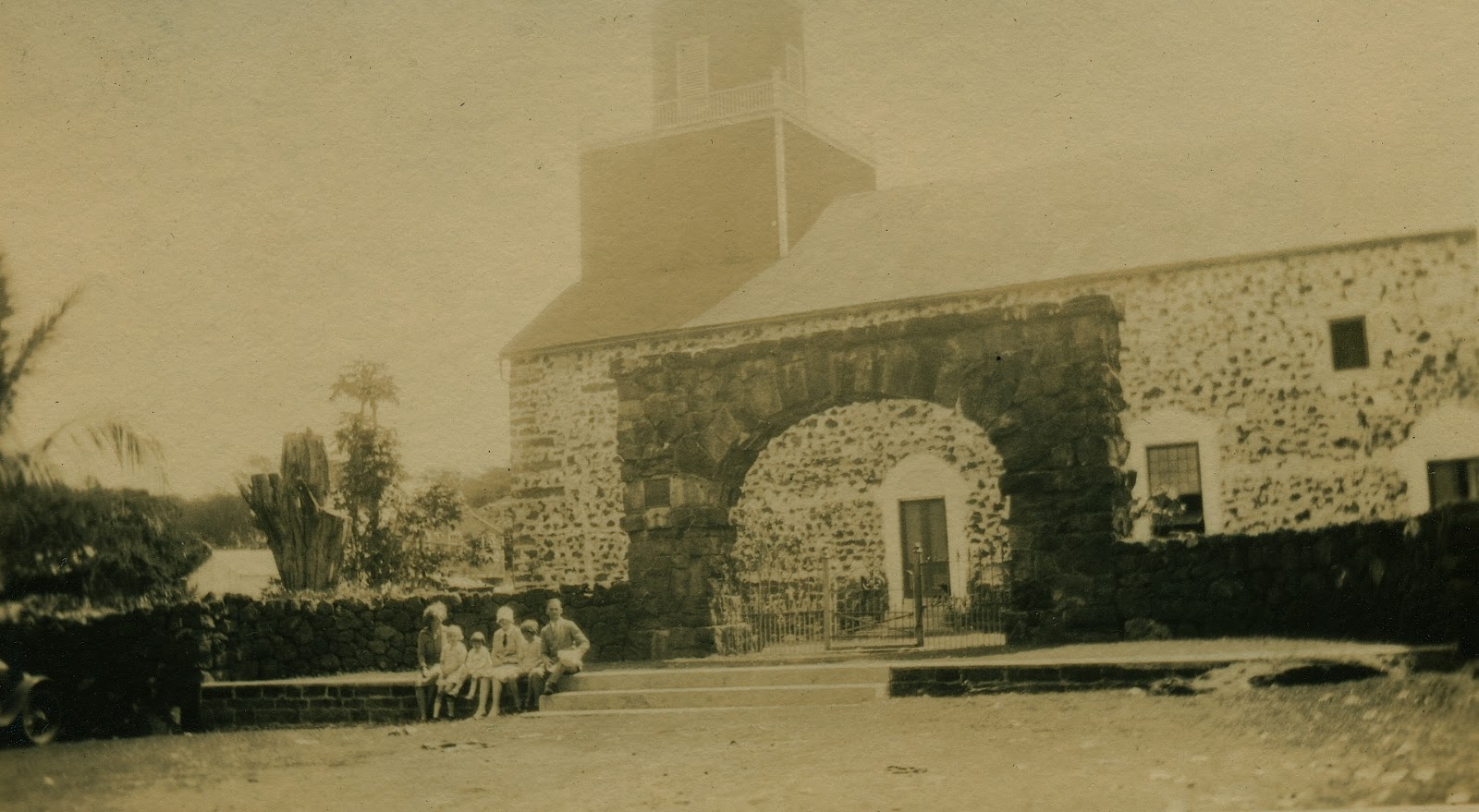
In the meantime, here’s a photo I haven’t shared yet.  The littlest girl near the middle is my mother; my grandparents are the couple on the right.

The others are noted as the “Scotts.” They were taking a tour around the Island of Hawaii, June 5-15, 1928.

They are sitting at the archway fronting Mokuʻaikaua Church in Kailua-Kona.  Construction of the church was started in 1835; it was dedicated in early-1837 (under the leadership of missionary Asa Thurston.)

The archway was built in 1910 to commemorate the 90th anniversary of the arrival of the first Protestant missionaries (1820.)

My grandfather was great grandson of Hiram and Sybil Bingham; Hiram was the leader of the Pioneer Company of missionaries to the Islands.

This year marks the 195th anniversary of the arrival of the Pioneer Company.  Plans are already underway for the celebration of the bicentennial of their arrival.  I am honored and proud to serve on the Board of the Hawaiian Mission Houses Historic Site and Archives.

If you haven’t recently visited the Mission Houses, I encourage you to visit – there are lots of things to see and learn there.

It’s on King and Kawaiahaʻo Streets (Diamond Head side of Kawaiahaʻo Church (designed by Hiram Bingham;) across King Street from the red brick Mission Memorial Building (dedicated in 1916 in anticipation of the centennial celebration.))

The Mission Memorial Building is on the site of the former Kawaiahaʻo Seminary; my great great aunt, Lydia Bingham, was principal of the seminary; her sister Lizzy later took over.

Kawaiahaʻo Seminary (for girls) and Mills School (for boys - started by Francis Damon) later merged and relocated to a site in Mānoa.  It’s now called Mid-Pacific Institute.

OK, back to the posts …

So, just to prepare you, the formatting of the posts will change – the full posts will be on the new website and short summaries will be posted in Facebook, Blogger, Google+ and LinkedIn – with links noted in the latter to get you directly to the website and the full posts.  (Special thanks to Jen Barrett for setting it up.)

An alternative (and preferred) way to get the posts is to subscribe on the website (no charge) – that way, you will receive an e-mail notice as soon as the post is made (with links to the full post.)  (Subscription sign-up is noted on the new website.)

Some other things are also in the works: ‘soon,’ podcasts, with imagery and reading of the full text, will be available.

Likewise, I am still looking for an economical way to get the posts noted on a web-based map – so you can see where these people, places and events took place.

I have a prototype on my computer … it is waaay cool and helps put a modern perspective (location) to the historical context.

Other ideas are in the works, as well.

So, stand by, the ‘regular’ post for today will be available soon.

© 2015 Hoʻokuleana LLC

Sunday, November 30, 2014

Charles Lambert


Kalākaua had a great interest in science and he saw it as a way to foster Hawai‘i’s prestige, internationally.

The opportunity to demonstrate this interest and support for astronomy was made available with the astronomical phenomenon called the “Transit of Venus,” which was visible in Hawai‘i in 1874.

"The coming transit of Venus will be observed from about 75 stations, at many of which there will be a large number of instruments. ... Wherever knowledge can be gained it is worth being gained ... these expeditions will lead to most valuable results."  (George Forbes, Chief Astronomer)

The King allowed the British Royal Society’s expedition to set up three sites in the Islands, Honolulu’s waterfront in a district called Apua (mauka of today’s Waterfront Plaza,) Kailua-Kona at Huliheʻe Palace and Waimea, Kauai.

The mission of the British expedition was to observe a rare transit of Venus across the Sun for the purpose of better determining the value of the Astronomical Unit – the Earth-to-Sun distance – and from it, the absolute scale of the solar system.

The orbits of Mercury and Venus lie inside Earth’s orbit, so they are the only planets which can pass between Earth and Sun to produce a transit (a transit is the passage of a planet across the Sun's bright disk.)

Professor George Forbes was the Chief Astronomer for the British expedition.  He befriended Charles Lambert, eldest son of an English gentleman residing at Coqnimbo in Chile.  (Lambert, not one of the astronomers, had been invited by his friend Captain Ralph P Cator, (Commander of the 'Scout') to accompany him in his cruise to the Hawaiian Islands.)

"(Lambert) had come out for his health on the 'Scout,' from Valparaiso, his father being one of the richest copper-mine owners in Chile. He intended to stay here a short time with the Venus Transit party (Prof. Forbes and Barnacle.)  (Pacific Commercial Advertiser, December 5, 1874)

Then, the fateful day ... not December 8, 1874 (the date of the Transit of Venus) - rather, November 20, 1874 when tragedy struck.

"During three days previously a Kona had been blowing into the bay, and having on Thursday seen the natives using the surf-board, Mr Forbes and his friend (Lambert) thought of trying their hands at it."

"They were furnished by the Hon. Simon Kaʻai, Sheriff and Representative of the District, with surf-boards, he not considering that there was any danger in so doing."

"Professor Forbes entered the water first.  When it was up to his chest, being about thirty yards from the shore, he began to look out for a good wave to try to ride in upon."

"Not having been successful and happening to look round he found that he was a hundred and fifty yards from the shore, having been carried out by the under current.  He did not however at that time apprehend any danger."

"A small native boy, an adopted son or Simon Kaai, now shouted to him, gesticulating and pointing to Mr Lambert, who was about fifty yards nearer to the shore than himself.  He saw that Mr Lambert had let go of his surf-board, and was in difficulty."

Forbes reached Lambert and tried to bring them both in to shore.  "He made however no head way, but was drifted farther out, and it then occurred to him that there was no prospect of either of them being saved, and he resolved to hold up his friend until they should both go down together." (Hawaiian Gazette, December 2, 1874)

Folks on shore were able to bring a canoe out through the surf.  Henry Weeks, a carpenter putting up the astronomical buildings, and a local swam "out to their assistance, but (Weeks) was soon exhausted and was just able to reach the canoe."  (Pacific Commercial Advertiser, December 5, 1874)

"The surf was at this time dashing against the rocks at their side so that landing seemed impossible. ... Ten minutes after Professor Forbes became absolutely exhausted; his arms lost their power, and it was only with the greatest difficulty that he was able to hold on to Mr Lambert, every wave engulphing them both."

Lambert drowned.

"The Professor with the dead body of his friend was put into (the canoe,) and reached the shore in safety."

"Great credit is due to Simon Kaʻai for his attempts to aid Professor Forbes and his friend, he (Simon Kaʻai) stated that he was much flurried, and that was why he did not think of a canoe sooner."

"Thanks also are due to Mr Bergman, a German resident here, for coming off in the canoe, and likewise to the stepmother of Simon Kaʻai for the same service."

"Mr Lambert met his end, as all who knew him must have felt that he would, with fortitude and resignation, it is believed that he died without pain; and the calmness of his expression showed that he died in peace."

"The conduct of Professor Forbes, in whose arms Mr Lambert drew his last breath, and who, with unequalled courage and devotion, risked and would have sacrificed his life to save that of his friend, is beyond all praise."  (Hawaiian Gazette, December 2, 1874)

Lambert "was buried the next day, twelve natives carrying the coffin to the English Episcopal Church in South Kona.  The case is all the sadder from the circumstance that Lambert was actually improving here with a good prospect of completely recovering his health."  (Pacific Commercial Advertiser, December 5, 1874)

On December 8, 1874, the transit was observed by the British scientists; however, the observation at Kailua-Kona was interrupted by occasional clouds.  The Honolulu and Waimea sites were considered perfect throughout the event, which lasted a little over half a day.

Ironically, on December 8, 1874 the big day, the king was absent, being in Washington to promote Hawaiian interests in a new trade agreement with the United States.

When American astronomer Simon Newcomb combined the 18th century data with those from the 1874/1882 Venus transits, he derived an Earth-sun distance of 149.59 +/- 0.31 million kilometers (about 93-million miles), very close to the results found with modern space technology in the 20th century.

After the Transit of Venus observations, Kalākaua showed continued interest in astronomy, and in a letter to Captain RS Floyd on November 22, 1880, he expressed a desire to see an observatory established in Hawai‘i.  He later visited Lick Observatory in San Jose.

Perhaps as a result of the King’s interest, a telescope was purchased from England in 1883 for Punahou School.  The five-inch refractor was later installed in a dome constructed above Pauahi Hall on the school's campus.

The image shows a calmer day in Kailua Bay.  (ca 1890) In addition, I have included other related images in a folder of like name in the Photos section on my Facebook and Google+ pages.

Follow Peter T Young on Facebook  

Follow Peter T Young on Google+ 

Follow Peter T Young on LinkedIn   

© 2014 Hoʻokuleana LLC

Thursday, October 23, 2014

Hewahewa


“Kailua Harbor, April 5, 1820. In the dawn of the day, as we passed near shore, several chiefs were spending their idle hours in gambling, we were favored with an interview with Hewahewa, the late High Priest. He received us kindly and on his introduction to Brother Bingham he expressed much satisfaction in meeting with a brother priest from America, still pleasantly claiming that distinction for himself.”  (Loomis)

“He assures us that he will be our friend. Who could have expected that such would have been our first interview with the man whose influence we had been accustomed to dread more than any other in the islands; whom we had regarded and could now hardly help regarding as a deceiver of his fellow men. But he seemed much pleased in speaking of the destruction of the heiau and idols.”

“About five months ago the young king consulted him with respect to the expediency of breaking taboo and asked him to tell him frankly and plainly whether it would be good or bad, assuring him at the same time that he would be guided by his view. Hewahewa speedily replied, maikai it would be good, adding that he knew there is but one "Akoohah" (Akua) who is in heaven, and that their wooden gods could not save them nor do them any good.”    (Loomis)

“Hewahewa, the high priest, had ceased to believe in the power of the ancient deities, and his highest chiefs, especially the state queen Kaahumanu, resolved to abolish the oppressive "kapu" system.  The king, ʻIolani Liholiho, had been carefully trained in the traditions of his ancestors and it was not an easy matter to foresake the beliefs of his fathers.  He was slow to yield to the sentiments of the chiefs.”  (Honolulu Star-bulletin, February 1, 1915)

“The ancient system consisted in the many tabus, restrictions or prohibitions, by which the high chiefs contrived, to throw about their persons a kind of sacredness, and to instil into the minds of the people a superstitious awe and peculiar dread.”

“If the shadow of a common man fell on a chief, it was death; if he put on a kapa or a malo of a chief, it was death; if he went into the chief's yard, it was death; if he wore the chief's consecrated mat, it was death; if he went upon the house of the chief, it was death.”

“If a man stood on those occasions when he should prostrate himself, (such as) when the king's bathing water... (was) carried along, it was death. If a man walked in the shade of the house of a chief with his head besmeared with clay, or with a wreath around it, or with his head wet... it was death.”

“There were many other offenses of the people which were made capital by the chiefs, who magnified and exalted themselves over their subjects.”  (Dibble)

Shortly after the death of Kamehameha I in 1819, King Kamehameha II (Liholiho) declared an end to the kapu system.  In a dramatic and highly symbolic event, Kamehameha II ate and drank with women, thereby breaking the important eating kapu.

“When the ruling aliʻi of the realm renounced the old religion in 1819, with the collaboration of no less a person than Hewahewa, the high priest of the whole kingdom, the foundation upon which the validity of the kahuna had for so long rested crumbled and fell away.”  (Kanahele)

“By the time Liholiho made his fateful decision, many others, including the high priest Hewahewa, whose position in the religious hierarchy could be compared to that of a pope, evidently had concluded that the old gods were not competent to meet the challenges that were being hurled at them by the cannons, gadgets and ideas of the modern world.”  (Kanahele)

“(Hewahewa) publicly renounced idolatry and with his own hand set fire to the heiau. The king no more observed their superstitious taboos. Thus the heads of the civil and religious departments of the nation agreed in demolishing that forbidding and tottering taboo system”.  (Loomis)

“I knew the wooden images of deities, carved by our own hands, could not supply our wants, but worshiped them because it was a custom of our fathers. My thoughts has always been, there is only one great God, dwelling in the heavens.” Hewahewa also prophesied that a new God was coming and he went to Kawaihae to wait for the new God, at the very spot were the missionaries first landed.

This changed the course of the civilization and ended the kapu system, and effectively weakened the belief in the power of the gods and the inevitability of divine punishment for those who opposed them.

The end of the kapu system by Liholiho (Kamehameha II) happened before the arrival of the missionaries; it made way for the transformation to Christianity and westernization.

“The tradition of the ships with white wings may have been the progenitor of the Hawaiians' symbol for Lono during the Makahiki. … With so many ships with white sails coming to Hawaii at that time, how would he know which ship would bring the knowledge of the true God of Peace?”

“He could not have known that, although the missionaries set sail on October 23rd, one day before the Makahiki began, they would take six months to arrive. Therefore, it was quite prophetic that, when he saw the missionaries’ ship off in the distance, he announced ‘The new God is coming.’ One must wonder how Hewahewa knew that this was the ship.”  (Kikawa)

“Hewahewa knew the prophesy given by Kalaikuahulu a generation before. This prophesy said that a communication would be made from heaven (the residence of Ke Akua Maoli, the God of the Hawaiians) by the real God. This communication would be entirely different from anything they had known. The prophecy also said that the kapus of the country would be overthrown.”

“Hewahewa also knew the prophesy of the prophet Kapihe, who announced near the end of Kamehameha's conquests, ‘The islands will be united, the kapu of the gods will be brought low, and those of the earth (the common people) will be raised up.’ Kamehameha had already unified the islands, therefore, when the kapus were overthrown, Hewahewa knew a communication from God was imminent.”  (Kikawa)

After the overthrow of the kapu system, Hewahewa retired to Kawaihae, to wait confidently for the coming of a “new and greater God.”  (Kikawa)

“Hewahewa departed for Kailua Bay (formally Kaiakeakua—Seaside of God) ahead of the missionaries to await their arrival with the King. After Hewahewa's departure, the missionaries’ ship entered Kawaihae. Hewahewa’s household told the Hawaiians accompanying the missionaries the astounding news that the kapus had been overthrown! The missionaries ship was then directed to Kailua Bay were the King was in residence.”

At Kailua, Hewahewa gave an even more astounding prophecy, he pointed to a rock on the shore and said to the new king, ‘O king, here the true God will come.’ When the missionaries arrived at Kailua, they landed their skiff on that very rock! This rock is commonly known as the ‘Plymouth Rock of Hawaiʻi.

In 1820, Hewahewa, the highest religious expert of the kingdom, participated in the first discussions between missionaries and chiefs. He welcomed the new god as a hopeful solution to the current problems of Hawaiians and understood the Christian message largely in traditional terms. He envisioned a Hawaiian Christian community led by the land's own religious experts.  (Charlot)

“Hewahewa … expressed most unexpectedly his gratification on meeting us … On our being introduced to (Liholiho,) he, with a smile, gave us the customary ‘Aloha.’”

“As ambassadors of the King of Heaven … we made to him the offer of the Gospel of eternal life, and proposed to teach him and his people the written, life-giving Word of the God of Heaven. … and asked permission to settle in his country, for the purpose of teaching the nation Christianity, literature and the arts.”  (Bingham)

Hewahewa later retired to Oʻahu and became one of the first members of the church established there. This church is located in Haleiwa and is called the Liliʻuokalani Protestant Church.  (Kikawa)  “He lived in the valley of Waimea, a faithful, consistent follower of the new light.”  (The Friend, March 1, 1914)

The image shows Hewahewa and the destruction of the heiau.  (Artwork done by Brook Kapukuniahi Parker.)

Follow Peter T Young on Facebook  

Follow Peter T Young on Google+    

Follow Peter T Young on LinkedIn   

© 2014 Hoʻokuleana LLC

Sunday, October 12, 2014

James Kahuhu


On October 23, 1819, the Pioneer Company of American Protestant missionaries from the northeast US set sail on the Thaddeus for the Sandwich Islands (now known as Hawai‘i.)  There were seven American couples sent by the ABCFM in this first company.

These included two Ordained Preachers, Hiram Bingham and his wife Sybil and Asa Thurston and his wife Lucy; two Teachers, Mr. Samuel Whitney and his wife Mercy and Samuel Ruggles and his wife Mary; a Doctor, Thomas Holman and his wife Lucia; a Printer, Elisha Loomis and his wife Maria; and a Farmer, Daniel Chamberlain, his wife and five children.

By the time the Pioneer Company arrived, Kamehameha I had died and the centuries-old kapu system had been abolished; through the actions of King Kamehameha II (Liholiho,) with encouragement by former Queens Kaʻahumanu and Keōpūolani (Liholiho’s mother,) the Hawaiian people had already dismantled their heiau and had rejected their religious beliefs.

One of the first things the missionaries did was begin to learn the Hawaiian language and create an alphabet for a written format of the language.   Their emphasis was on teaching and preaching.

The first mission station was at Kailua-Kona, where they first landed in the Islands, then the residence of the King (Liholiho, Kamehameha II;) Asa and Lucy Thurston manned the mission, there.

Liholiho was Asa Thurston's first pupil. His orders were that “none should be taught to read except those of high rank, those to whom he gave special permission, and the wives and children of white men.”

James Kahuhu and John ʻlʻi were two of his favorite courtiers, whom he placed under Mr. Thurston's instruction in order that he might judge whether the new learning was going to be of any value.  (Alexander, The Friend, December 1902)

In 1820, Missionary Lucy Thurston noted in her Journal, “The king (Liholiho, Kamehameha II) brought two young men to Mr. Thurston, and said: ‘Teach these, my favorites, (John Papa) Ii and (James) Kahuhu. It will be the same as teaching me. Through them I shall find out what learning is.’”

“To do his part to distinguish and make them respectable scholars, he dressed them in a civilized manner. They daily came forth from the king, entered the presence of their teacher, clad in white, while his majesty and court continued to sit in their girdles.”

“Although thus distinguished from their fellows, in all the beauty and strength of ripening manhood, with what humility they drank in instruction from the lips of their teacher, even as the dry earth drinks in water!”

“After an absence of some months, the king returned, and called at our dwelling to hear the two young men, his favorites, read. He was delighted with their improvement, and shook Mr. Thurston most cordially by the hand - pressed it between both his own - then kissed it.” (Lucy Thurston)

Kahuhu was among the earliest of those associated with the chiefs to learn both spoken and written words. Kahuhu then became a teacher to the chiefs.

In April or May 1821, the King and the chiefs gathered in Honolulu and selected teachers to assist Mr Bingham.  James Kahuhu, John ʻĪʻi, Haʻalilio, Prince Kauikeaouli were among those who learned English.  (Kamakau)

On October 7, 1829, it seems that Kauikeaouli (Kamehameha III) set up a legislative body and council of state when he prepared a definite and authoritative declaration to foreigners and each of them signed it.  (Frear – HHS)  Kahuhu was one of the participants.

King Kamehameha III issued a Proclamation "respecting the treatment of Foreigners within his Territories."  It was prepared in the name of the King and the Chiefs in Council:  Kauikeaouli, the King; Gov. Boki; Kaʻahumanu; Gov. Adams Kuakini; Manuia; Kekūanāoʻa; Hinau; ʻAikanaka; Paki; Kīnaʻu; John ʻIʻi and James Kahuhu.

In part, he states, "The Laws of my Country prohibit murder, theft, adultery, fornication, retailing ardent spirits at houses for selling spirits, amusements on the Sabbath Day, gambling and betting on the Sabbath Day, and at all times.  If any man shall transgress any of these Laws, he is liable to the penalty, - the same for every Foreigner and for the People of these Islands: whoever shall violate these Laws shall be punished."

It continues with, "This is our communication to you all, ye parents from the Countries whence originate the winds; have compassion on a Nation of little Children, very small and young, who are yet in mental darkness; and help us to do right and follow with us, that which will be for the best good of this our Country."

The Hawaiʻi State Archives is the repository of significant historic documents for Hawaiʻi; reportedly, the oldest Hawaiian language document in its possession is a letter written by James Kahuhu.

Writing to Chief John Adams Kuakini, Kahuhu’s letter was partially in English and partially Hawaiian (at that time, Kuakini was learning both English and written Hawaiian.)

Below is a transcription of Kahuhu's letter.  (HSA)

Oahu. Makaliʻi 12, 1822.
Kawaiahaʻo.
My Dear Chief Mr. John Adams Kuakini. I love you very much. This is my communication to you. Continue praying to Jehovah our God. Keep the Sabbath which is God’s holy day. Persevere in your learning the good Gospel of Jehovah. By and by perhaps we shall know the good word of Jesus Christ. Then we shall know the good word of God.

A few begin to understand the good word of God. I am very pleased with the good word of God which has been brought here to enlighten this dark land. Who will save our souls and take them up to heaven, the place of eternal life. I am presently teaching Nahiʻenaʻena. I am teaching seven of them. Nahienaena, Kauikeaouli, Halekiʻi, Ulumāheihei Waipa, Ulumāheihei a Kapalahaole, Nakapuai and Noaʻawa are the students I am teaching. I may have more in the future. You must obey your good teacher, Hopu. Persevere with him and don’t give up.

Keliʻiahonui has learned to write quite well, he sent a letter to Oahu. Tell Hopu that Keliʻiahonui misses him. The King is learning to write from Mr. Bingham. Kalanimōku, Kīnaʻu and Kekauōnohi are learning to write Hawaiian. Mr. Thurston is their teacher. Here is another word to you, if you see Kalapauwahiole tell him to come to Oahu as I would like very much for him to come to Oahu.
James Kahuhu

(Makaliʻi was the name of a month: December on Hawai‘i, April on Moloka'i, October on Oʻahu.  (Malo))

The image shows the first page of the Kahuhu letter to Kuakini (HSA.)    In addition, I have included other images in a folder of like name in the Photos section on my Facebook and Google+ pages.

Follow Peter T Young on Facebook  

Follow Peter T Young on Google+    

Follow Peter T Young on LinkedIn   

© 2014 Hoʻokuleana LLC

Saturday, October 11, 2014

Kaiakeakua


Royal Centers were where the aliʻi resided.

The Royal Centers were selected for their abundance of resources and recreation opportunities, with good surfing and canoe-landing sites being favored.

The Hawaiian court was mobile within the districts the aliʻi controlled. A Chief's attendants might consist of as many as 700 to 1000-followers, made of kahuna and political advisors; servants which included craftsmen, guards, stewards; relatives and others.  (NPS)

Aliʻi often moved between several residences throughout the year.  There was no regular schedule for movement between Royal Centers.  In part, periodic moves served to ensure that district chiefs did not remain isolated, or unsupervised long enough to gather support for a revolt.  (NPS)

For centuries, Kaiakeakua (also spelled Kaiakekua) was a favored place for royalty.

“Perhaps … because it was a place celebrated for the constant appearance of fishes. Sometimes kule, fish that burrow in the sand … for there is sand (at) Kaiakekua …” (John Papa ʻIʻi)

"This sandy stretch, called Kaiakekua was a canoe landing, with some houses mauka of it. ... Its fresh water came up from the pāhoehoe and mixed with the water of the sea."

"It was a gathering place for those who went swimming and a place where the surf rolled in and dashed on land when it was rough. ... just makai was a patch of sand facing north, where canoes landed".  (John Papa ʻIʻi)

"There were chiefs and families of chiefs ...(and) ... The sands of Kaiakeakua were worn down like a dromedary's (camel's) back by the many feet of chiefs and chiefesses tramping over them, and ... could be seen at night the sparkle of lights reflected in the sea like diamonds, from the homes of the chiefs.... The number of chiefs and lesser chiefs reached into the thousands".  (Kamakau)

At about the same time of Christopher Columbus crossing the Atlantic to America (he was looking for an alternate trade route to the East Indies,) ʻUmi-a-Līloa (ʻUmi) moved his Royal Center there.

ʻUmi was famous for his battle with the gods. His wife Piʻikea, had supernatural grandmothers, who were Hapuʻu and Kalaihauola, and who desired to have a grandchild that they might take to Oʻahu to bring up, because the mother of Piʻikea, Laieloheloheikawai, belonged to Oahu.

Laieloheloheikawai sent the supernatural grandmothers to Hawaiʻi to obtain one of Piʻikea's children. When they arrived in Hawaiʻi ʻUmi refused to permit a child to be taken.  ʻUmi offered to fight the deities at the sandy plains.

However, human beings battle with their hands, clubs and stones, but the gods without hands, and when the battle was fought the gods were victorious over the battle of men. The place is called Kaiakeakua - sea of the god - to this day.  (Fornander)

Lonoikamakahiki ca. 1640-1660 was tested at Kaiakeakua by Kanaloakuaʻana. “I want to be positive of your great skill, hence I have brought you here for that test and to satisfy myself that you are indeed a master.”

“There were about thirty spearmen to throw at the same time. After the men were ready and the spears thrown it was seen that Lonoikamakahiki was not hit by a single one of them.”  The test was continued from 30 spears to 80 spears, and Lonoikamakahiki was not hit.  (Fornander)

Some early writers called this place “Kayakakoua.” Joseph Paul Gaimard, zoologist on a French scientific expedition commanded by Louis de Freycinet during the years 1817-20, speaks of Kayakakoua.

"It is located on the beach and appears to consist of about four hundred houses, if you can apply this term to the smallest of huts which are not more than two or three feet high."

"There are no streets and the habitations are scattered without any order.  In addition there are three buildings for storing powder and a large storeroom built of stone covered with lime."

"The dock yards, storehouses and the principal nautical workshops of the king are also located there.  At each end of the town stands a morai (heiau) a simple elevation surrounded by a stake fence and filled with gigantic wooden idols."

Oh, the name Kaiakeakua has gone out of use ... today we simply call this place Kailua (in Kona on the Island of Hawaiʻi.)  The remnant of the once sandy beach of Kaiakeakua sits adjacent to the Kailua Pier - it's where the Ironman Triathlon World Championship starts each year.

Ironman takes place there, today.  For 13-years, I was Ironman's Director of Aid Stations (1990-2002.)  We had about 4,000-volunteers and over 30-bike and run aid stations for the approximate 1,200-contestants.  Volunteering for Ironman was a great experience; I miss it.

The image shows Kaiakeakua, Kailua Bay.  (1935) In addition, I have included other related images in a folder of like name in the Photos section on my Facebook and Google+ pages.

Follow Peter T Young on Facebook  

Follow Peter T Young on Google+ 

Follow Peter T Young on LinkedIn   

© 2014 Hoʻokuleana LLC

Sunday, May 11, 2014

Happy Mother’s Day!


The image shows my mother and grandmother in 1928 (my mother is the little girl sitting to the left, her mother is sitting nearby, wearing a hat.)

The scene is at Kailua-Kona at a site known as Pa O ʻUmi; over the years, most of this outcrop of land has been covered over with Aliʻi Drive – a small remnant remains extending beyond today’s seawall.

Here is where Chief ʻUmi-a-Liloa (who reigned about the same time Christopher Columbus was crossing the Atlantic) landed when he first came to Kailua by canoe, moving the Island’s Royal Center from Waipiʻo to Kailua.

On this point of rock ʻUmi ordered his attendant to dry his precious feather cloak (ʻahuʻula.)  (The site is also referred to as Ka Lae O ʻAhuʻula.)

My mother was the great-great grand-daughter of Hiram Bingham, leader of first missionaries to Hawaiʻi who first landed in the Islands, here at Kailua-Kona in 1820.  (Mokuaikaua Church, built by Bingham’s fellow missionary, Asa Thurston, is in the background, as well as Huliheʻe Palace (to the right.))

Follow Peter T Young on Facebook 

Follow Peter T Young on Google+ 

Follow Peter T Young on LinkedIn   

© 2014 Hoʻokuleana LLC

Monday, March 24, 2014

Keahuolū


The area of North Kona between Kailua Bay and Keauhou Bay to the south is generally recognized as containing the population core and the most fertile agricultural area of North Kona (Kona Kai ʻOpua “Kona of the distant horizon clouds above the ocean”.)  (Maly)

To the north of Kailua Bay, beginning at Honokōhau, is the relatively dry Kekaha district of North Kona, with its barren lava inlands and coastal fishponds (Kekaha-wai-ʻole-nā-Kona (the waterless place of Kona, it’s described as "a dry, sun-baked land.")

Keahuolū is situated in the transition zone between these two contrasting environmental districts, and is immediately north of Kailua Bay, a center of both political and economic activities since before Western contact.

Keahuolū has been translated in a couple ways, “Ke-ahu-o-Lū” (the ahu (or alter) of Lū) and “Keʻohuʻolu” (the refreshing mists) – similar to the neighboring (to the south) Lanihau ahupuaʻa (cool heaven.)

A hill at Keahuolū and adjoining Kealakehe (to the north) is associated with mists.  “The settling of mists upon Puʻu O Kaloa was a sign of pending rains; thus the traditional farmers of this area would prepare their fields.”  (This notes the importance of rain in this relatively dry area.)  (Cultural Surveys)

Several general settlement pattern models have been generated by researchers that generally divide up the region into five basic environmental zones: the Shoreline, Kula, Kaluʻulu, ʻApaʻa and ʻAmaʻu.

Habitation was concentrated along the shoreline and lowland slopes, and informal fields were probably situated in the Kula and higher elevations, areas with higher rainfall.

The Shoreline zone extends, typically, from the high-tide line inland a few hundred feet. In Kailua this is the area from the shore to approximately Aliʻi Drive.  In this zone, permanent settlement began in Kona c. AD 1000-1200. Several large and densely populated royal centers were situated at several locations along the shoreline between Kailua and Honaunau.

Several heiau were noted along the coast. Stokes described three coastal heiau sites in Keahuolū: Halepuʻa, Kawaluna and Palihiolo. Halepuʻa was described by Stokes as a koʻa, or fishing shrine, near the shore in a coconut grove.  Kawaluna Heiau was described by Stokes as a rebuilt enclosure located on the beach at Pāwai Bay. Heiau of Palihiolo was at or near the Keahuolū/Lanihau boundary, King Kalākaua had it rebuilt prior to his departure from Hawaiʻi.  (Rosendahl)

The Kula zone (the plain or open country) consisted primarily of dry and open land with few trees and considerable grass cover.  With limited soil, and lots of rock, this land was planted primarily in scattered sweet potato patches.  (This area was around the 500-foot elevation mark, and may extend further, to approximately the 600-800-foot elevation.)

The Kaluʻulu is zone is referred to as the breadfruit zone. Early explorers described this zone as breadfruit with sweet potatoes and wauke (paper mulberry) underneath; it may have been perhaps one-half mile wide. Here walled fields occur at the 600-800-foot elevation, which may be start of this breadfruit zone in this area.

The ʻApaʻa zone is described as a dryland taro and sweet potato zone (1,000-foot elevation and extended to the 2,500-foot elevation.) In historic accounts it is described as an area divided by low stone and earth walls into cleared rectangular fields in which sweet potato and dryland taro were planted. On the edges of the walls, sugarcane and ti were planted.

The ʻAmaʻu zone is the banana zone, which may extend from the 2,000-foot elevation to 3,000-feet, and is characterized by bananas and plantains being grown in cleared forest areas.  (Rosendahl)

William Ellis (1822) noted, “The houses which are neat, are generally erected on the sea-shore, shaded with cocoanut and kou trees, which greatly enliven the scene. The environs were cultivated to a considerable extent; small gardens were seen among the barren rocks on which the houses are built, wherever soil could be found sufficient to nourish the sweet potato, the watermelon, or even a few plants of tobacco, and in many places these seemed to be growing literally in the fragments of lava, collected in small heaps around their roots.”

King Kalākaua later (1869) noted, “Keahuolu runs clear up to the mountains and includes a portion of nearly half of Hualalai mountains.  On the mountains the koa, kukui and ohia abounds in vast quantities.  The upper land or inland is arable, and suitable for growing coffee, oranges, taro, potatoes, bananas &c.  Breadfruit trees grow wild as well as Koli (castor-oil) oil seed.  The lower land is adopted for grazing cattle, sheep, goats &c.  The fishery is very extensive and a fine grove of cocoanut trees of about 200 to 300 grows on the beach.”

A sisal plantation was planted in Keahuolu in the late-1890s, a mill was constructed nearby; sisal was used to make rope and other fibers.  Operating until 1924, the McWayne sisal tract included about 1,000-acres of sisal fields in Keahuolu and adjoining Kealakehe.  (You can still see sisal plants, remnants of the sisal plantation, as you drive up Palani Road.)

A fishing village with a canoe landing was at Pāwai Bay.  Makaʻeo (later (July 10, 1949) developed into the Kailua Airport (commercial aviation ended there July 1, 1970)) had a large cocoanut grove, with a coastal trail running through it connecting Kailua Village to the Māmalahoa Trail.

The Kuakini Wall (1830-1844,) built to keep the free-ranging livestock out of the coastal settlements and gardens, extends from Kahaluʻu Bay to the southern portion of Keahuolu (with an average distance of about 1 ½ miles from the coastline.)  It goes to, but not through, Keahuolū at its northern terminus.

The ahupuaʻa of Keahuolū was awarded to Analeʻa Keohokālole ((c. 1816-1869) mother of King Kalākaua and Queen Liliʻuokalani) during the Māhele of 1848. Two walled houselots in Keahuolū had been held by Keohokālole’s ancestors "from very ancient times".

Keohokālole was a great-granddaughter of both Kameʻeiamoku and Keaweaheulu two of the important chiefs who supported Kamehameha I in his rise to power.  Kameʻeleihiwa states, “Keohokālole was regarded by the Kamehameha clan as an Aliʻi Nui in honor of the great courage and loyalty proffered by her ancestors in their support of Kamehameha.”

As Aliʻi Nui, Keohokālole held the fifth largest number of ʻāina after the Māhele with 50 parcels.  She relinquished 48% of her original 96 ʻāina to the Mōʻī (King) retaining 23-parcels on Hawaiʻi, 25 on Maui and two on Oʻahu. Of her lands on the island of Hawaiʻi, two-thirds were located in the Kona District.  (Wong-Smith)

Keohokālole sold portions of her 15,000-20,000-acre grant to the government and other parties, with the balance being transferred to her heir, Liliʻuokalani.

In her Deed of Trust dated December 2, 1909, which was later amended in 1911, Queen Lili‘uokalani entrusted her estate to provide for orphan and destitute children in the Hawaiian Islands, with preference for Hawaiian children. Her legacy is perpetuated through the Queen Liliʻuokalani Children’s Center.

The image shows the makai portion of Keahuolu over Google Earth with some sites and place names added.  In addition, I have added other related images in a folder of like name in the Photos section on my Facebook and Google+ pages.

Follow Peter T Young on Facebook  

Follow Peter T Young on Google+ 

© 2014 Hoʻokuleana LLC

Monday, June 10, 2013

Kona Airport at Kailua


Interisland air travel was initiated in Hawaiʻi on November 11, 1929, by Stanley Kennedy, a WWI aviator who acquired two Sikorsky S-38 Amphibian aircraft and initiated direct service from Honolulu to Hilo (3 times a week) via Maʻalaea, Maui, and to Port Allen, Kauaʻi (2 times a week). Later, service was added to Molokaʻi.

For a number of years, Kailua-Kona was only serviced by seaplanes.  Then (after clearing an area of rocks the week before,) on August 21, 1935, Alfred W Smith landed his single-seated monoplane about a mile north of Kailua, the first airplane ground landing ever made in Kona.

By the late-1930s, there was a public push to provide an airport at Kailua, Kona.  An area parallel to the beach, previously used for small aircraft operations, and known as Kailua Airstrip, was determined to be the only suitable area in the vicinity. It was located about 1½-miles northwest of the Kona Inn.

“It is believed that the proposed airport would result in a great increase in tourist interest in the area and also in the development of vacation homes for residents of Honolulu,” stated a Department of Public Works report.

“The general opening up of the area by providing means for quicker transportation to Honolulu would tend to interest young people of Oahu in the possibility of establishing themselves in the Kona area (where land is relatively available) and thus help solve the land scarcity problem which is critical on Oahu."  (hawaii-gov)

“The shipment of Kona fruits and vegetables to Honolulu by air freight would be economically practicable both for sale in Honolulu and, during certain periods of the year, for trans-shipment to California.”  (hawaii-gov)

In late-1940, applications were prepared and processed under the provisions of the 1940 National Airport Act.  The next year funds were allotted, but construction never started.  Finally, in 1944 the Post War Planning Division of the Territorial Public Works Department proposed proceeding with the airport when the war was over.

Surveys were made and plans prepared by the Department of Public Works, and in May 1948 bids were opened for construction of a runway 100-feet wide by 3,500-feet long, an aircraft parking mat and an access road connecting the main road through the village of Kailua.

Work was started June 10, 1948.  Due to the multiple ‘Kailua’ names for various items, including airports (there was another private airport at Kailua, Oʻahu,) on February 7, 1949 the airport was named Kona Airport.

On July 10, 1949 between 3,000 and 4,000 people gathered at the new Kona Airport for the official opening and ceremonies.  Acting Governor Oren E Long officially declared the airport open for commercial air transportation, and said he “hoped that in spite of the trade and prosperity that the district would inherit, Kona would remain noted for its hospitality and not become a Great White Way marred by neon signs and a Coney Island atmosphere.”   (hawaii-gov)

Hawaiian Airlines President Stan Kennedy announced that additional weekend flights would be made by his airline on the Kona Coaster every Friday afternoon from Honolulu and returning every Sunday afternoon.  “Kona will become, now more than ever, a must for the tourist as well as for local travel,” Kennedy said.

Hawaiian Airlines was the first commercial plane to arrive at the airport from Honolulu via Molokai at 11:30 am bringing a full load of passengers and the first direct air mail from Oahu.  It took off at noon bound for Honolulu with passengers and air mail.

Over the next few years the facility was expanded and the runway lengthened.   However, the location of the airport, with planes flying over Kailua-Kona and nearby residences, started to raise concerns - especially with the increasing number of flights and the need for further expansion with a longer runway to accommodate larger aircraft.

Less than 10-years after it opened, in 1957, there were discussions and planning for the relocation of the airport.  Part of the plan was to sell the old airport site for the development of a tourist resort, in order to fund construction of a new airport to replace those facilities.

However, in the interim, in 1966, the runway was lengthened as a stop gap measure to accommodate the growing size of the interisland carriers' planes.

On June 30, 1970, Kona Airport was closed and all operations were moved to the new Keāhole Airport with operations beginning at the new airport on July 1, 1970, with the new Queen Kaʻahumanu Highway built to that point.

For three summers, I worked for Aloha Airlines, starting at the “Old” Kona Airport - initially throwing bags, then as a ramp agent greeting and saying farewell to the planes as they landed/departed.

The summer of 1970, we moved the airline office furniture and supplies, slowing moving with our tugs and baggage carts piled high along the new Queen Kaʻahumanu Highway to the new Keāhole Airport (extension of Queen Kaʻahumanu Highway to Kawaihae was completed in 1975.)

After the old airport’s closure, its runway was used as a drag strip until the State and the County converted it to a recreational park around 1976. The runway is used as a parking area and access road for the former State park area.

While the State still owns the site, while I was at DLNR, the Board of Land and Natural Resources approved the set aside (assignment of management jurisdiction) of the former airport site to the County of Hawai‘i for park and recreational purposes.  (Apparently, the final transfer to the County has been delayed, pending the state relocating its baseyard on the former airport site.)

In October 2010, the State completed the Kona International Airport at Keāhole Airport Master Plan which provides a long-range vision of the developments on airport property.  Recently (March 2013,) an EIS preparation notice was filed for proposed airfield improvements and airport facilities related to that plan that are anticipated to be implemented within the next five to ten years.

The image shows an Inter-Island Airways taking off from historic Kailua Bay (the early means of air travel in and out of Kailua-Kona.)   In addition, I have added other images in a folder of like name in the Photos section on my Facebook and Google+ pages.

Follow Peter T Young on Facebook  

Follow Peter T Young on Google+  

© 2013 Hoʻokuleana LLC

Thursday, April 4, 2013

Pioneer Company


The coming of Henry Obookiah (ʻŌpūkahaʻia) and other young Hawaiians to the continent had awakened a deep Christian sympathy in the churches and moved the American Board of Commissioners for Foreign Missions (ABCFM) to establish a mission in the Hawaiian Islands.

Among the other Hawaiian students at the Foreign Mission School were Thomas Hopu, William Kanui, John Honoliʻi and Prince Humehume (son of Kauaiʻi’s King Kaumuali‘i.)

When asked “Who will return with these boys to their native land to teach the truths of salvation?”  Hiram Bingham and his classmate, Asa Thurston, were the first to respond and offer their services to the Board.  (Congregational Quarterly)

Bingham and Thurston were ordained at Goshen, Ct on September 29, 1819; it was the first ordination of foreign missionaries in the State of Connecticut.

On October 23, 1819, the Pioneer Company of American Protestant missionaries from the northeast US set sail on the Thaddeus for the Sandwich Islands (now known as Hawai‘i.)

There were seven American couples sent by the ABCFM to convert the Hawaiians to Christianity in this first company.

These included two Ordained Preachers, Hiram Bingham and his wife Sybil and Asa Thurston and his wife Lucy; two Teachers, Mr. Samuel Whitney and his wife Mercy and Samuel Ruggles and his wife Mary; a Doctor, Thomas Holman and his wife Lucia; a Printer, Elisha Loomis and his wife Maria; and a Farmer, Daniel Chamberlain, his wife and five children.

Although a large part of the motivation for the Hawaiʻi missionary movement, Henry ʻŌpūkahaʻia unfortunately died of typhus fever in 1818 and didn’t return home to teach the gospel.  However, his book, “Memoirs of Henry Obookiah,” was the inspiration for this and subsequent Hawaiian missionary companies.

The Prudential Committee of the ABCFM in giving instructions to the pioneers of 1819 said: “Your mission is a mission of mercy, and your work is to be wholly a labor of love. … Your views are not to be limited to a low, narrow scale, but you are to open your hearts wide, and set your marks high. You are to aim at nothing short of covering these islands with fruitful fields, and pleasant dwellings and schools and churches, and of Christian civilization.”  (The Friend)

After 164-days at sea, on April 4, 1820, the Thaddeus arrived and anchored at Kailua-Kona on the Island of Hawaiʻi.  Hawai‘i’s “Plymouth Rock” is about where the Kailua pier is today.

By the time the Pioneer Company arrived, Kamehameha I had died and the centuries-old kapu system had been abolished; through the actions of King Kamehameha II (Liholiho,) with encouragement by former Queens Kaʻahumanu and Keōpūolani (Liholiho’s mother,) the Hawaiian people had already dismantled their heiau and had rejected their religious beliefs.

One of the first things Bingham and his fellow missionaries did was begin to learn the Hawaiian language and create an alphabet for a written format of the language.   Their emphasis was on teaching and preaching.

On July 14, 1826, the missionaries selected a 12-letter alphabet for the written Hawaiian language, using five vowels (a, e, i, o, and u) and seven consonants (h, k, l, m, n, p and w) in their "Report of the committee of health on the state of the Hawaiian language."   The report is signed by Hiram Bingham and Levi Chamberlain.

The arrival of the first company of American missionaries in Hawaiʻi marked the beginning of Hawaiʻi’s phenomenal rise to literacy. The chiefs became proponents for education and edicts were enacted by the King and the council of chiefs to stimulate the people to reading and writing.

By 1831, in just eleven years from the first arrival of the missionaries, Hawaiians had built 1,103 schoolhouses. This covered every district throughout the eight major islands and serviced an estimated 52,882 students.  (Laimana)

The proliferation of schoolhouses was augmented by the printing of 140,000 copies of the pīʻāpā (elementary Hawaiian spelling book) by 1829 and the staffing of the schools with 1,000-plus Hawaiian teachers.  (Laimana)

Interestingly, these same early missionaries taught their lessons in Hawaiian, rather than English.  In part, the mission did not want to create a separate caste and portion of the community as English-speaking Hawaiians.  In later years, the instruction, ultimately, was in English.

Within five years of the missionaries’ arrival, a dozen chiefs had sought Christian baptism and church membership, including the king’s regent Kaʻahumanu.  The Hawaiian people followed their native leaders, accepting the missionaries as their new priestly class.  The process culminated in Hawaiian King Kamehameha III’s adoption of Christianity and a Biblically-based constitution in 1840.  (Schulz)

Over the course of a little over 40-years (1820-1863) (the “Missionary Period”,) about 180-men and women in twelve Companies served in Hawaiʻi to carry out the mission of the ABCFM in the Hawaiian Islands.

Today, the Hawaiian Mission Children's Society, a nonprofit educational institution and genealogical society, exists to promote an understanding of the social history of nineteenth-century Hawai‘i and its critical role in the formation of modern Hawai‘i.

The Society operates the Hawaiian Mission Houses Historic Site and Archives, comprised of three historic houses and a research archives with reading room. The Society also compiles the genealogical records of the American Protestant missionaries in Hawai‘i and promotes the participation of missionary descendants in the Society's activities.

Through the Site and Archives, the Society collects and preserves the documents, artifacts and other records of the missionaries in Hawai‘i's history; makes these collections available for research and educational purposes; and interprets the historic site and collections to reflect the social history of nineteenth century Hawai‘i and America.

The image shows the early Mission house and Chapel in Honolulu (the precursor of today’s Kawaiahaʻo Church.)  More images are added to a folder of like name in the Photos section on my Facebook and Google+ pages.

Follow Peter T Young on Facebook  

Follow Peter T Young on Google+  

© 2013 Hoʻokuleana LLC

Thursday, December 6, 2012

Mokuʻaikaua Church


This stone and mortar building, completed in 1837, is the oldest surviving Christian church in the state of Hawaiʻi, started by the first Protestant missionaries to land in Hawaiʻi.

With the permission of Liholiho (Kamehameha II), the missionaries built a grass house for worship in 1823 and, later, a large thatched meeting house.

Missionary Asa Thurston directed the construction of the present Mokuʻaikaua Church, then the largest building in Kailua-Kona. Its massive size indicates the large Hawaiian population living in or near Kailua at that time.

Mokuʻaikaua, with its 112-foot-tall steeple, is a reminder of the enthusiasm and energy of the first American missionaries and their Hawaiian converts.

Built of stones taken from a nearby heiau and lime made of burned coral, it represents the new western architecture of early 19th-century Hawaiʻi and became an example that other missionaries would imitate.

The original thatch church which was built in 1823 but was destroyed by fire in 1835, the present structure was completed in 1837. Mokuʻaikaua takes its name from a forest area above Kailua from which timbers were cut and dragged by hand to construct the ceiling and interior.

Mokuʻaikaua Church is centered in a small level lot near the center of Kailua. Its high steeple stands out conspicuously and has become a landmark from both land and sea.

Huge corner stones, said to have been hewn by order of King ʻUmi in the 16th century for a heiau, were set in place and offers evidence of the heavy labor which contributed to the Church's construction.

The central core of the steeple is polygonal with alternating sections of wide and narrow clapboard.  The wider sections are articulated with louvered arches. The 48 by 120 feet lava rock and coral mortared church is capped with a gable roof.

Construction beams are made from ʻōhiʻa wood. Pieces of the wooden structure were joined with ʻōhiʻa pins.  The spanning beams are fifty feet long and are made from ʻōhiʻa timbers. Corner stones were set in place 20 to 30 feet above the ground.

Mokuʻaikaua Church is the first and one of the largest stone churches in Hawaiʻi, outstanding for its simple, well-proportioned mass and construction.

The interior open timber structure with high galleries is a fine architectural and engineering design. The architectural interest is further enhanced by the church's historical significance (it is on the Register of Historic Places.)

In 1910, a memorial arch was erected at the entrance to the church grounds to commemorate the arrival of the first missionaries.

Congregationalist missionaries from Boston crossed the Atlantic Ocean, rounded Cape Horn, aboard the Brig Thaddeus.   A replica of the Thaddeus is in Mokuʻaikaua Church.

On the morning of April 4, 1820, 163 days from Boston, the Congregational Protestant missionaries, led by Hiram Bingham, aboard the Thaddeus, came to anchor off the village of Kailua.

They came ashore at the “Plymouth Rock” of Hawaiʻi, where Kailua Pier now stands.  Christian worship has taken place near this site since 1820.  Mokuʻaikaua is known as the "First Christian Church of Hawaiʻi."

Inspired by the dream of Hawaiian Henry ʻŌpūkahaʻia, seven couples were sent by the American Board of Commissioners for Foreign Missions to convert the Hawaiians to Christianity.

Two Ordained Preachers Hiram Bingham and his wife Sybil and Asa Thurston and his wife Lucy; Two Teachers, Mr. Samuel Whitney and his wife Mercy and Samuel Ruggles and his wife Mary; A Doctor, Thomas Holman and his wife Lucia; A Printer, Elisha Loomis and his wife Maria; A Farmer, Daniel Chamberlain, his wife and five children.

The Thurstons remained in Kailua, while their fellow missionaries went to establish stations on other Hawaiian islands.

The photo was taken in 1928, it shows my grandparents and mother (on the right is my grandfather, the great grandson of Hiram Bingham; the little girl (shortest-near the middle) to the right of my grandmother is my mother, the great-great granddaughter of Hiram Bingham.)

In addition to this, I have included other images of Mokuʻaikaua Church in a folder of like name in the Photos section on my Facebook and Google+ pages.

http://www.facebook.com/peter.t.young.hawaii

http://plus.google.com/108947657421184863425

© 2012 Hoʻokuleana LLC

Monday, August 20, 2012

Ka Pā Nui o Kuakini (Great Wall of Kuakini)


Captain George Vancouver gave a few cattle to Kamehameha I in 1793; Vancouver strongly encouraged Kamehameha to place a kapu on them to allow the herd to grow.

In the decades that followed, cattle flourished and turned into a dangerous nuisance.  By 1846, 25,000 wild cattle roamed at will and an additional 10,000 semi‐domesticated cattle lived alongside humans.

John Adams Kuakini was an important adviser to Kamehameha I in the early stages of the Kingdom of Hawai‘i.

When the Kingdom's central government moved to Lāhaina in 1820, Kuakini’s influence expanded on Hawaiʻi Island, with his appointment as the Royal Governor of Hawaiʻi Island, serving from 1820 until his death in 1844.

During his tenure, Kuakini built many of the historical sites that dominate Kailua today.  The Great Wall of Kuakini, probably a major enhancement of an earlier wall, was one of these.

The Great Wall of Kuakini extends in a north-south direction for approximately 6 miles from Kailua to near Keauhou, and is generally 4 to 6-feet high and 4-feet wide.

Built between 1830 and 1840, the Great Wall of Kuakini separated the coastal lands from Kailua to Keauhou from the inland pasture lands.

The mortar-less lava-rock wall has had varying opinions regarding the purpose of its construction.

Speculation has ranged from military/defense to the confinement of grazing animals; however, most seem to agree it served as a cattle wall, keeping the troublesome cattle from wandering through the fields and houses of Kailua.

It is likely that the function of the wall changed over time, as the economic importance of cattle grew and the kinds and density of land use and settlement changed.

Kuakini was responsible for other changes and buildings in the Kona District during this era.

He gave land to Asa Thurston to build Moku‘aikaua Church.

He built Huliheʻe Palace in the American style out of native lava, coral lime mortar, koa and ‘ōhi‘a timbers.  Completed in 1838, he used the palace to entertain visiting Americans and Europeans with great feasts.

He made official visits to all ships that arrived on the island, offering them tours of sites, such as the Kīlauea volcano.

He was born about 1789 with the name Kaluaikonahale.  With the introduction of Christianity, Hawaiians were encouraged to take British or American names.

He chose the name John Adams after John Quincy Adams, the US president in office at the time.  He adopted the name, as well as other customs of the US and Europe.

Kuakini was the youngest of four important siblings: sisters Queen Kaʻahumanu, Kamehameha's favorite wife who later became the powerful Kuhina nui, Kalākua Kaheiheimālie and Namahana-o-Piʻia (also queens of Kamehameha) and brother George Cox Kahekili Keʻeaumoku.

He married Analeʻa (Ane or Annie) Keohokālole; they had no children.  (She later married Caesar Kapaʻakea.  That union produced several children (including the future King Kalākaua and Queen Liliʻuokalani.))

Hulihe‘e Palace is now a museum run the Daughters of Hawaiʻi, including some of his artifacts.

A highway is named "Kuakini Highway," which runs from the Hawaii Belt Road through the town of Kailua-Kona, to the Old Kona Airport Recreation Area.

He is also the namesake of Kuakini Street in Honolulu, which is in turn the namesake of the Kuakini Medical Center on it.

The image shows a portion of the Great Wall of Kuakini; in addition, I have added a few other images and maps of the wall n a folder of like name in the Photos section on my Facebook page.

http://www.facebook.com/peter.t.young.hawaii

© 2012 Hoʻokuleana LLC

Monday, July 9, 2012

Wai‘aha, Kailua-Kona (Birth-Beach of the Bodyboard)


Many may not realize that today’s Bodyboard was created in Kailua-Kona, at Wai‘aha, a place commonly referred to as “Honl’s” (after the name of the family that used to live there.)

Wai‘aha (“Gathering Water,”) a little strip of white sand beach, just on the outskirts of Kailua Village, is now a County Beach Park.   It is a popular surf spot, especially with bodyboarders.

Tom Morey was staying in the house that once stood on the beach at Wai‘aha in July 1971 when he made the first bodyboard ("boogie board”) prototype.

He first called the board “S.N.A.K.E.” (Side, Navel, Arm, Knee, Elbow – because all the body parts were involved in its use) – he trademarked the name Morey Boogie in 1973 and founded Morey Boogie in 1974.  (He later called it a Boogie Board after his love of music.)

According to Tom Morey's son, Sol Morey, "the first boogie board was created in 1971 in order to surf shallower breaks that couldn't otherwise be enjoyed.”

“The surf at our Hawaii rental on the Kailua coast was where it began with the shaping and sealing of the foam to form the first boogie.”

Tom Morey was a traditional surfboard builder/shaper, but looked for inventions and innovation.  In 1964, he created the first TRAF polypropylene fin (his term TRAF being FART spelled backward), innovating the first commercial interchangeable fin system. In 1965, the Skeg Works became Morey Surfboards.

In 1965, Karl Pope became his business partner and the name changed again -- Morey-Pope Surfboards.  They built, tested and marketed Pope's Trisect, a three-piece surfboard that folded into a suitcase.

But he had different ideas in Kona; he used an electric carving knife and a household iron, whittled some scrap polyethylene foam into a small rectangular mat and covered it with newspaper and hit the swells in front of his home on the Big Island of Hawaii.

With it, the sport of bodyboarding started in 1971 in Hawaii.  (Prior to 1971, bodyboards were made from wood or fiberglass and called paipo boards.)

According to Tom Morey, he took his last nine-foot piece of polyethylene foam (that he had planned for a conventional board) and “grabbed a knife and cut it in half.”

“There was no turning back at that point.  I looked at the foam and then at the surf and began fooling around with a hot iron and an electric knife.”

“I found that I could shape the foam using the iron if I put a sheet of newspaper down on the foam first. Later that night, I drew a few curves on the foam with a red marking pen and went to bed.”

Morey rose early on July 9, 1971, and cut and ironed out his planned shape. He left his board as wide as possible and left the nose square so that it would have more structural strength and so he could hold on to it.

“I decided I’d shape the rails like those on a Hot Curl surfboard,” says Morey. “Those were the boards from the 20s and 30s; built before boards had skegs. I cut 45-degree Hot Curl rails into my board.”

“They looked great, but I still wasn’t sure how it would ride.” Morey grabbed his board, ran down to Honl’s and the sport of bodyboarding was born.

Wai‘aha is home to the annual Malama Wai‘aha (Honl’s) Roots Bodyboard contest.  The contest (started in 2002) was formed to honor the birth-beach and the birthplace of modern bodyboarding (they held their 10th anniversary event on June 30.)

In 2006, the Hawai‘i County acquired the property fronting the beach and it is now part of the County beach park system.  Parking for users is also mauka of Ali‘i Drive and was provided by a developer as a condition of a rezoning.

Morey Bodyboards became a division of Mattel Toys and then Wham-O.  In 2005, Tom Morey earned a star on the Huntington Walk of Fame and was inducted into the Surfing Hall of Fame.

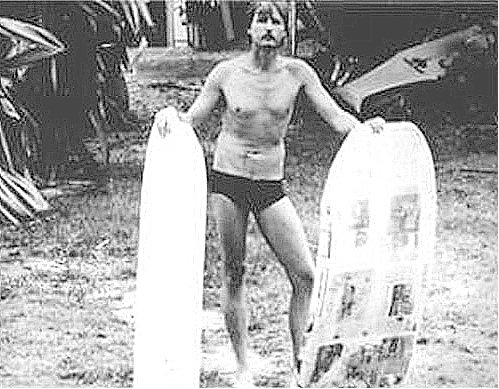
The image shows Tom Morey with the original S.N.A.K.E.; info and images from tommorey-com.  In addition, I have added other images of bodyboards, Morey and Wai‘aha in a folder of like name in the Photos section.

Friday, June 29, 2012

Hulihe‘e Palace – Kailua-Kona


Hulihe‘e Palace is Kona’s only existing royal residence and one of three palaces in the United States.  (The other two are ‘Iolani Palace and Queen Emma's Summer Palace, both on O‘ahu.) 

Hulihe‘e, built in 1838, was the residence of Governor John Adams Kuakini and a favorite retreat for Hawai‘i’s royal families.

The Palace was constructed by foreign seamen using lava rock, coral, koa and ōhi‘a timbers.  Kuakini oversaw the construction of both Mokuaikaua Church and Hulihe‘e Palace and these landmarks once shared a similar architectural style with exposed stone.

After Kuakini’s death in 1844, the Palace passed to his adopted son, William Pitt Leleiohoku.  Leleiohoku died a few months later, leaving Hulihe‘e to his wife, Princess Ruth Luka Ke‘elikōlani.  It became a favorite retreat for members of the Hawaiian royal family.

Flanked to the north by Niumalu and to the south by Kiope Fish Pond, Hulihe‘e Palace was also the site of the observation of the Transit of Venus (when the planet Venus crosses between the Earth and the Sun) in 1874 by British astronomers, one of the most important astronomical observations of the 19th century (helping to calculate the distance between the Sun and the Earth.)

When Princess Ruth passed away in 1883 leaving no surviving heirs, the property passed on to her cousin, Princess Bernice Pauahi Bishop.  Princess Bernice died the following year and the home was purchased by King David Kalākaua and Queen Kapi‘olani.

Extensive remodeling by King Kalākaua and Queen Kapi‘olani in 1884 transformed the original structure to suit the Victorian tastes of the late 19th century (with stucco and plaster, widened lanai, and much to the interior décor.)

Early description of Hulihe‘e Place (Hawai‘i Nei, by Mabel Clare Craft Deering – 1898:)
”There is a fine royal residence there, now the property of the dowager Queen Kapiolani. It is a big house with a wide hall and immense rooms. The kitchen and servants' quarters are detached, and there is an open lanai a little way from the house where Kalakaua gave famous luaus and hulas, and where his celebrated red chairs were set in rows.”

“The house is marked by the tabu-sticks set up at the doors, sticks with white balls at the top, in imitation of the old days when balls of white kapa at the top of the sticks marked the residence of the king, within which common people could not go on pain of death.”

“Inside, the house is a marvel of polished woods. There is a table of satiny koa, the mahogany of the Pacific, the" royal tree," fit to make you weep. This table stands in the center of the drawing-room, and around the walls are elaborate carved chairs, vases, and fine pottery from China and Japan. There are portraits of Kalakaua, Kapiolani, and Liliuokalani, as well as busts of royalty. At the windows are exquisite lambrequins of the finest kapa I saw on the islands, painted in patterns, and some of it extremely old.”

“The big dining-hall across the vestibule has a fine carved sideboard, and on it are a number of koa calabashes, polished, and marked inside with the crown and royal coat - of- arms, etched with a poker. These calabashes all have covers, and were designed for pink poi.”

In 1925, Hulihe‘e was purchased by the Territory of Hawai‘i to be operated as a museum by the Daughters of Hawai‘i. (My mother was a Daughter.)

Most of the furnishings were originally in the Palace during the Monarchy.  Hulihe‘e Palace was placed on the National Register of Historic Sites in 1973.

Hulihe‘e Palace contains a fine collection of ancient Hawaiian artifacts, as well as ornate furnishings that illustrate the lifestyle of the Hawaiian nobility in the late 19th century.  Intricately carved furniture, European crystal chandeliers and immense four-poster beds fill the rooms.

Hulihe‘e Palace reveals the Hawaiian nobility's passion for western fashions and is a reminder of Kailua's past as a favorite royal residence.

The image shows Hulihe‘e Palace and Princess Ruth’s hale on the palace grounds (while she used and enjoyed the Palace, she typically slept in the grass hale – 1885.)  In addition, I have added other images of Hulihe‘e place in a folder of like name in the Photos section on my Facebook page.


Tuesday, June 5, 2012

Transit of Venus – 1874 – 2012


Hawaii is tiny; we are a speck of islands within Earth’s largest ocean.  And, it is a metaphor for Earth’s place in space.

Interest in the heavens goes back far into the ancient fabric of Polynesian culture.  Many of the early Polynesian gods derived from or dwelt in the heavens, and many of the legendary exploits took place among the heavenly bodies.

Early Polynesians, who trusted their navigational instincts and skills to the nighttime stars above, currents, winds and waves, sailed thousands of miles over open ocean across the Pacific to Hawai‘i.

They had names for their star guides: Ka Maka - the point of the fishhook in the constellation Scorpius; Makali‘i – the Little Eyes within the Pleiades, Hoku‘ula – The Red Star in the constellation Taurus and Hokupa‘a – the North Star (fixed star,) as well as others.

After the Polynesians came, in 1778, the Europeans, under the command of Captain James Cook, arrived.  He brought with him spyglasses, clocks, sextants, charts, foreign ideas and techniques – new tools of navigation.

A new awareness of the skies was reborn under the scientific patronage of King David Kalākaua, (Kalākaua reigned over the Kingdom of Hawai‘i from 1874 to 1891.)

Kalākaua had a great interest in science and he saw it as a way to foster Hawai‘i’s prestige, internationally.

The opportunity to demonstrate this interest and support for astronomy was made available with the astronomical phenomenon called the “Transit of Venus,” which was visible in Hawai‘i in 1874.

The King allowed the British Royal Society’s expedition a suitable piece of open land for their viewing area; it was not far from Honolulu’s waterfront in a district called Apua (mauka of today’s Waterfront Plaza.)

They built a wooden fence enclosure and soon a well-equipped nineteenth-century astronomical observatory took shape, including a transit instrument, a photoheliograph, a number of telescopes and several temporary structures including wooden observatories.

Subsequently, auxiliary stations – though not so elaborate as the main station in Honolulu – were established in two other island locations: one at Kailua-Kona and the other at Waimea, Kaua‘i.

In addition, Hawai‘i was not the only site to observe the transit; under the British program, observations were also made in Egypt, Island of Rodriquez, Kerguelen Island and New Zealand.  (Other countries also conducted Transit observations.)

On Dec. 8, 1874, the transit was observed by the British scientists; however, the observation at Kailua-Kona was marred by clouds.  But the Honolulu and Waimea sites were considered perfect throughout the event, which lasted a little over half a day.

After the Transit of Venus observations, Kalākaua showed continued interest in astronomy, and in a letter to Captain RS Floyd on November 22, 1880, he expressed a desire to see an observatory established in Hawai‘i.  He later visited Lick Observatory in San Jose.

It was not long after this that a telescope was purchased from England in 1883 and set up at Punahou School.

In 1884, the five-inch refractor was installed in a dome constructed above Pauahi Hall on the school's campus (the first permanent telescope in Hawai‘i.)

In 1956, this telescope was installed in Punahou’s newly completed MacNeil Observatory and Science Center.  (Unfortunately, it is not known where that telescope is today.

Why was the Transit of Venus important?

Although Copernicus had, by the 16th century, put the known planets in their correct order, their absolute distances remained unknown.  Astronomers still needed a celestial yardstick of “Astronomical Units” with which to measure distances among the planets and to link the planets to the stars beyond.

The mission of the British expedition was to observe a rare transit of Venus across the Sun for the purpose of better determining the value of the Astronomical Unit – that is, the Earth-to-Sun distance – and from it, the absolute scale of the solar system.

The orbits of Mercury and Venus lie inside Earth’s orbit, so they are the only planets which can pass between Earth and Sun to produce a transit (a transit is the passage of a planet across the Sun's bright disk.)  Transits are very rare astronomical events; in the case of Venus, there are on average two transits every one and a quarter centuries.

Ironically, on December 8, 1874 the big day, the king was absent, being in Washington to promote Hawaiian interests in a new trade agreement with the United States.

When American astronomer Simon Newcomb combined the 18th century data with those from the 1874/1882 Venus transits, he derived an Earth-sun distance of 149.59 +/- 0.31 million kilometers (about 93-million miles), very close to the results found with modern space technology in the 20th century.

The image shows the Transit of Venus site at Apua, in Honolulu.  Much of the information here is from NASA and Institute for Astronomy.  In addition, I have posted other images, maps and related stuff on the Transit of Venus in a folder of like name in the Photos section.


Today (June 5, 2012,) we in Hawai‘i are again fortunate to be able to witness the Transit of Venus - beginning at 12:10 pm and ending at 6:45 pm (the next Transit of Venus will occur in 2117.)  There are lots of places across the State set up to help people witness this astronomical event.

Folks on Mauna Kea are hosting a live webcast: http://venustransit.nasa.gov/webcasts/nasaedge/

Remember - Never observe the sun with the naked eye or through a telescope, camera or other optical device.

Sunday, May 27, 2012

Kamakahonu Royal Center at Kailua Bay, Hawaiʻi Island


Kamakahonu Royal Center at Kailua Bay was the residential compound of Kamehameha I from 1813 until his death in 1819.

It had previously been the residence of a high chief, and it was undoubtedly a residential area back into the centuries prior to European contact. 

Kamakahonu (which literally means eyes of the turtle) was the location of multiple heiau known collectively as Ahu‘ena, originally said to have been built by either Liloa or his son Umi-a-Liloa during the sixteenth century, was reconstructed and rededicated by Kamehameha I in the early nineteenth century.

John Papa ʻĪʻī, attendant of Kamehameha I, to become a companion and personal attendant to Liholiho (later King Kamehameha II,) described Kamakahonu from on board a ship in 1812, “Kamakahonu was a fine cove, with sand along the edge of the sea  and  islets  of  pāhoehoe,  making  it  look like a  pond,  with a  grove of  kou trees a  little inland and a heap of pāhoehoe  in  the center of the stretch of sand.”

Kamehameha first moved into the former residence of Keawe a Mahi. He then built another house high on stones on the seaward side of that residence, facing directly upland toward the planting fields of Kuahewa.

Like an observation post, this house afforded a view of the farm lands and was also a good vantage from which to see canoes coming from the south.

The royal residence at Kamakahonu was served by a series of anchialine pools, upwellings of fresh and salt water found on young lava fields. These anchialine pools were used to raise bait fish and shrimp for larger catches.

During Kamehameha's use of this compound, reportedly 11 house structures were present. These included his sleeping house, houses for his wives, a large men's house, storehouses and Ahuʻena heiau. 

Kamehameha also included a battery of cannon and large stone walls to protect the fortress-like enclosure.

Upon Kamehameha's death, a mortuary house was built, which held his remains until they were taken and hidden away.

After Liholiho's departure from Hawaiʻi Island in 1820, the high chief Kuakini, who served as Governor of Hawai'i for many years, resided here until 1837, when he had Huliheʻe built and moved there.

By the late-1800s, Kamakahonu was abandoned and in the early-1900s H. Hackfield & Co. purchased the land, and its successor American Factors used the site as a lumberyard and later for the King Kamehameha Hotel.

Today, three remnant structures are present on the seaward beach of the property (all recreated in the 1970s and recently refurbished) - 'Ahu'ena heiau, the mortuary house's platform and an additional structural platform.

These structures are set aside in a covenant agreement between the State's Historic Preservation Division and the current hotel owners.

Kamakahonu became the backdrop for some of the most significant events in the early nineteenth-century history of the Hawaiian Kingdom.

Three momentous events occurred here which established Kamakahonu as one of the most historically significant sites in Hawaiʻi:
  • In the early morning hours of May 8, 1819 King Kamehameha I died here.
  • A few months after the death of his father, Liholiho (Kamehameha II) broke the ancient kapu system, a highly defined regime of taboos that provided the framework of the traditional Hawaiian socio-economic structure
  • The first Christian missionaries from New England were granted permission to come ashore here on April 4, 1820.

The property is now part of King Kamehameha's Kona Beach Hotel; none of the original houses or walls remain.

Ahuʻena heiau was reconstructed in the 1970s at 2/3-scale and can be viewed, but not entered.

The small sandy beach provides a protected beach for launching canoes and children swimming.  The first Hotel was built here in 1950; it was imploded (boy, that was an exciting day in Kona) and the current one constructed in 1975.

Kamakahonu is one of the featured Points of Interest in the Royal Footsteps Along The Kona Coast Scenic Byway.  We prepared the Corridor Management Plan for the Scenic Byway.

The image is a portion of a Kekahuna map (Bishop Museum) noting the Kamakahonu Royal Center.  In addition, I have placed other images and maps of Kamakahonu in a folder of like name in the Photos section on my Facebook page.