Tuesday, April 30, 2013

Immigration Station


By the middle of the 19th century the Hawaiian population had declined drastically through the impacts of disease and epidemics and  the  dispersal  of  the young men of  the  Kingdom on whaling  ships  and  seeking their  fortunes  in  the California gold  fields.

In 1850, the Hawaiian population was down to 46,500.  At the same time the American occupation of California and Oregon gave the islands a large, relatively close market for agricultural crops.

Starting in the 1850s, when the Hawaiian Legislature passed "An Act for the Governance of Masters and Servants," a section of which provided the legal basis for contract-labor system, labor shortages were eased by bringing in contract workers from Asia, Europe and North America.

In  1852,  the  first  group of  200  Chinese  labor  contract  immigrants were brought  in  to work in  the  sugar  plantations.   In the hundred years from 1850 to 1950, over 350,000 labor immigrants were brought in to supply workers for the plantations and to augment a declining population with people of kindred races.

For nearly one hundred years immigrants arriving in Hawaiʻi had their initial processing in the area of the present immigration building at the entrance to Honolulu Harbor.

In  the  19th  century they came  over  the  channel wharf to  be  processed at  the  pavilion and  quarters  of  the  Kingdom's  Quarantine and Immigration Depot built in 1879 on what was  popularly called Fisherman's Point.

King Kalākaua, who personally initiated Japanese immigration in a visit to the Emperor, visited the station to greet the initial group of Japanese laborers arriving in 1886.  After a hospitable welcome which  included entertainment  of hula dancers,  he  invited  some of the group to  the  Palace  to  display  their  skill  at  fencing.  (NPS)

The United States government took over immigration matters after annexation and built new structures out over the mud flats (which opened July 4, 1905.)

The buildings were designed to fit the climate and atmosphere of Hawaiʻi and to be an inviting place for immigrants to come through.  (This was the first use of terra cotta in Hawaiʻi.)

Although Herbert C.  Clayton was  the architect who  contracted  to  design the building,  it  is  quite evident  that  the architect associated with him for this project had the major design role,  CW Dickey.

The entrance portico designed by Dickey as  the most  important  architectural feature  of  the  building reflects  Hawaiʻi and  the  Immigration Station  function as  a bridge between East  and West.

The  portico is accented by Chinese architectural details  and  the  large bronze  compass  plaque  set  in the  floor  of  the  entrance  lobby shows  Hawaiʻi as  the  crossroads  of  the Pacific by  indicating distances  to  principle  cities  on  the  Pacific rim.

An interview with Mr. Dickey on July 27, 1934 in the Honolulu Star-Bulletin best describes the intent and execution of the complex in the designer's own words:
"In designing the new immigration station buildings the main objective was a group of buildings expressing the spirit and environment of Hawaiʻi and at the same time maintaining well balanced and well-proportioned masses, graceful lines and a pleasing color effect."

"This meant a wide departure from the more or less stereotyped stations of the mainland and it required no small amount of persuasion and diplomacy to get such a design accepted...."

“In general  the buildings  consist of  low lying masses of  cream colored stucco walls  surmounted by graceful  sloping roofs of variegated green and russet  tiles."

A special  area was  designed into  the building to  provide a  "matrimonial" room where Japanese girls, who had been married by proxy  in  Japan to men  living  in  Hawaiʻi,  met  their husbands for  the  first  time  and were  formally married.  These picture brides numbered 14,276 between the years 1907 and 1923.

Mr. AE Burnett, for many years the District Director of Immigration, hoped that the buildings would serve as a model for other stations across the nation.

The Dickey designed buildings were placed on the National Register of Historic Places (much of the information here came from those records.)

(By the way, in the existing immigration center, there is a fountain put in by Italian POWs from WWII – unfortunately, it is in a secured area and you can’t get directly to it.  However, you can see it through a chain link fence on the back side (makai) of the building.)

The image shows the Immigration Station in 1905; this was replaced by the present Dickey-designed facility.  (Lots of information here from NPS.)  In addition, I have added additional images in a folder of like name in the Photos section on my Facebook and Google+ pages.

Follow Peter T Young on Facebook  

Follow Peter T Young on Google+  

© 2013 Hoʻokuleana LLC

Monday, April 29, 2013

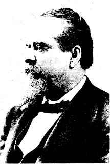
Samuel G Wilder


Samuel Gardner Wilder was born June 20, 1831 in Massachusetts. Wilder arrived in Honolulu in the clipper ship White Swallow in the year 1857, that same year he married Elizabeth Kinaʻu Judd, daughter of missionary doctor and politician Gerrit P. Judd.

Their honeymoon voyage to New York on the chartered White Swallow went via Jarvis Island, where Wilder picked a load of guano for sale on the continent.

“Samuel G Wilder has had the career of a man of more than ordinary ability and energy whose private enterprises and public services have both in a large degree been a benefit to the country of his adoption.”  (Hawaiian Gazette July 31, 1888.)

Upon returning to the islands, in 1864, Wilder and his father in law (Judd) set up a partnership for a sugar plantation at Kualoa, and built the mill and the stone chimney together.

The mill is associated with a tragedy when Willy Wilder, the nine year old son of Samuel Wilder, fell into a vat of boiling syrup during processing. He died a few days later from his severe burns.

By 1867, the decision to end the Judd-Wilder venture at Kualoa was made.  The mill ground its last crop during the summer of 1868.  After the failure of the plantation, the land was used a pasture for cattle and horses under the name of Kualoa Ranch.

He was later in the lumber business, but his wealth and prominence started in the interisland steam transportation business.  Starting with the Kilauea, then the Likelike, then many more, he formed a flotilla of interisland carriers and later organized them under the Wilder Steamship Company.

The Wilder organization had strong competition from the Inter-Island Steam Navigation Company, which developed from the activities and interests of Captain Thomas R. Foster.

In 1905, the Wilder Steamship Company merged with the Inter-Island Steam Navigation Company, forming the largest fleet of steamers serving Hawaiʻi. That company started the first scheduled commercial airplane service in 1929 as Inter-Island Airways and became Hawaiian Airlines in 1941.

His life included politics and King Lunalilo appointed Wilder to the House of Nobles.  King Kalākaua later appointed Wilder to his Cabinet, where he served as Minister of the Interior from 1878-1880.

He was a businessman rather than a politician, and his watchword was efficiency and economy in administration. He applied to the business of government the same ability and energetic leadership that won him success in his private business enterprises.  (Kuykendall)

Mr. Wilder’s administration of the Department of the Interior was characterized by a well-defined policy of extensive internal improvements.  Wilder vigorously pushed forward the construction of roads and bridges with other public conveniences, including the Marine Railway.  (Hawaiian Gazette July 31, 1888)

During his term in office that Kulaokahuʻa, the “plains,” between Alapaʻi and Punahou streets mauka of King Street in Honolulu, was opened for settlement. Work on ʻIolani Palace was begun and preliminary railroad surveys were made on the island of Hawaiʻi. Wilder’s influence was felt in all departments of the government.  (Kuykendall)

In 1878 Wilder established the first telephone line on Oʻahu, from his government office to his lumber business.  King Kalākaua then purchased telephones for ʻIolani Palace.  (Charles Dickey in Haiku, Maui had the first phones in the islands (1878;) connecting his home to his store.)

In 1881, Wilder initiated a railroad connecting the Mahukona port with the plantations in North Kohala on the Big Island (Niuliʻi to Mahukona;) he later bought the Kahului Railroad Company.

Wilder was appointed and later elected to the legislative assembly and served as its president.  “He was a practical parliamentarian; just, prompt and precise in his rulings combining rare tact with energy in the dispatch of business.”  Hawaiian Gazette July 31, 1888)

At this time, the Bayonet Constitution was enacted which created a constitutional monarchy much like that of the United Kingdom – this stripped the King of most of his personal authority and empowered the legislature.

The 1887 constitution made the upper house of the legislature elective and replaced the previous absolute veto allowed to the king to one that two-thirds of the legislature of the Hawaiian Kingdom could override.   Wilder supported the monarchy and told the King that he did not think the monarchy could last much longer.  (Kuykendall)

Mr. Wilder had advised the King to enter at once into negotiations with the United States to part with the sovereignty of the country while he was in a position to do so with advantage, and before affairs became more complicated.  Kalākaua did not follow the advice given to him by Wilder.  (Kuykendall)

King Kalākaua conferred upon Mr. Wilder the distinctions of a Knight Commander of the Royal Order of Kalākaua and Grand Officer of the Royal Order Crown of Hawaiʻi.

“This generous and many-sided man tended with loving care to the deserving, with charitable purpose to the poor and with patriotic conscientiousness to the wants of his country.”  (Daily Bulletin August 7, 1888)

The former Kaʻahumanu Wall, from Punchbowl to Mōʻiliʻili, followed a trail which was later expanded and was first called Stonewall Street.  It was also known as “Mānoa Valley Road;” later, the route was renamed for Samuel G. Wilder (and continues to be known as Wilder Avenue.)

The image shows Samuel G Wilder; in addition, I have added other images in a folder of like name in the Photos section on my Facebook and Google+ pages.

Follow Peter T Young on Facebook  

Follow Peter T Young on Google+  

© 2013 Hoʻokuleana LLC

Sunday, April 28, 2013

Kailua, Oʻahu


About 6,000 years ago and before the arrival of the Hawaiians, Kawainui (the large [flow of] fresh water) and Ka‘elepulu (the moist blackness) were bays connected to the ocean and extended a mile inland of the present coastline (as indicated by inland deposits of sand and coral.)

A sand bar began forming across Kawainui Bay around 2,500 years ago creating Kawainui Lagoon filled with coral, fish and shellfish.  The Hawaiians probably first settled along the fringes of this lagoon.   Gradually, erosion of the hillsides surrounding Kawainui began to fill in the lagoon with sediments.

About 500 years ago, early Hawaiians maintained a freshwater fishpond in Kawainui; the fishpond was surrounded on all sides by a system of ʻauwai (canals) bringing water from Maunawili Stream (winding/twisted mountain) and springs to walled taro lo‘i (irrigated fields.)

In 1750, Kailua (two seas (probably two currents)) was the Royal Center of power for the district of Koʻolaupoko and a favored place of the O‘ahu chiefs for its abundance of fish and good canoe landings (and probably enjoyed the surf, as well.)  Kawainui was once the largest cultivated freshwater fishpond on Oʻahu.

Farmers grew kalo (taro) in the irrigated lo‘i along the streams from Maunawili and along the edges of the fishponds.  Crops of dryland kalo, banana, sweet potato and sugarcane marked the fringes of the marsh. Fishermen harvested fish from the fishponds and the sea.

In 1845 the first road was built over the Nuʻuanu Pali (cool height – cliff) to connect Windward Oʻahu with Honolulu.  It was jointly financed by the government and sugar planters who wanted easy access to the fertile lands on the windward side of Oʻahu.  Kamehameha III and two of his attendants were the first to cross on horseback.

(In 1898 this road was developed into a highway and was later replaced by the Pali Highway.  When the current Pali Highway and its tunnels opened (1959,) the original roadway was closed and is now used by hikers.)

Lili‘uokalani wrote “Aloha ‘Oe” (farewell to thee) after an 1878 visit to an estate in Maunawili.  She and her brother King David Kalākaua were regular guests and attended parties or simply came there to rest.  Guests would walk between two parallel rows of royal palms, farewells would be exchanged; then, they would ride away on horseback or in their carriages.

In the 1880s, Chinese farmers converted the Kawainui taro fields to rice; they later abandoned their farms by 1920. Cattle grazed throughout much of Kawainui.  The marsh drains into the ocean at the north end of Kailua Beach through Kawainui Canal (Oneawa Channel – built in the late-1940s.)

In 1923, planning began for the Coconut Grove subdivision.  That year, Elsie’s Store, the site of the existing Kalapawai Market (the rippling water or the shining water,) opened for business. Lanikai Store (heavenly sea,) currently Kailua Beach Center, was across the street.  (Kāneʻohe Ranch)

Shortly after that, Kailua’s first real estate subdivision was built, called Lanikai Crescent.  In 1926, Kailua Country Club opened; it was later named Mid-Pacific Country Club.  (Kāneʻohe Ranch)

In 1939, the Oʻahu Jockey Club built the Kailua Race Track – the place was nicknamed the ‘Pineapple Derby.’  In a day and age when Seabiscuit and War Admiral were stealing continental sports headlines, more than 6,000 fans turned out for 10 races at the brand new Kailua Race Track.  (Hogue, MidWeek)  Races reportedly continued there into 1952.

It’s not clear when it opened, but in the 1940s and ‘50s, there is clear evidence of the “Kailua Airport” (apparently, gravel/grass runway) – where ʻAikahi Park is situated today (reportedly, privately-owned and operated by Bob Whittinghill.)  (When work was started in 1948 on the new airport in Kailua, Kona, to avoid confusion with the Kailua Airport on Oʻahu, the Big Island’s airport was named “Kona Airport.”)

The 1950s saw expanded development and growing population in Kailua.  Kāneʻohe Ranch Company, Paul Trousdale and Hawaiian Housing Corporation joined together with several housing developments, including developments in ʻAikahi (to eat all,) Kaimalino (calm or peaceful sea,) Kalāheo (the proud day,) Mōkapu (sacred district,) Olomana (forked hill) and Pōhakupu (growing rock.)  (Kāneʻohe Ranch)  Kailua's population growth took a giant leap from 1,540 (in 1940,) to 7,740 (in 1950) - then another giant leap to over 25,600 people in 1960.

Homes were generally priced from $9,250 to $13,500.  The first increment of homes in the Kalāheo subdivision, built by QC Lum, was selling for $9,250 on lots of 7,500-square feet. The annual land lease was $125, regardless of size. Later developments in Olomana, Pōhakupu and Kūkanono (stand strike) were priced at about $17,000.  (Windward Rotary)  The Pali Golf Course opened in 1953.

The first traffic signal in Kailua was installed at the intersection of Kuʻulei and Kailua Roads in 1954. That year, Foodland opened Windward Oʻahu’s first modern supermarket across from Kailua Beach Park.  A couple years later (1957,) Times Supermarket opened in the new Kailua Shopping Center.  (Kāneʻohe Ranch)

In 1956, the YMCA moved from its log cabin in Coconut Groove to the present site on Kailua Road. In 1957, Kailua High School graduated its first class.  Prior to this time, mail delivery was directed to ‘Lanikai;’ at the end of the decade, the post office name was changed to Kailua.

Other subdivisions were developed at ʻAikahi Park, Keolu Hills (pleasant,) Olomana and Maunawili Estates.   Homes in ʻAikahi Park sold for about $25,000. Shopping centers sprouted in ʻAikahi Park and Enchanted Lake to serve the incoming residents.  (Windward Rotary)

Harold KL Castle donated land and Hawaiʻi Loa College (now known as Hawaiʻi Pacific University) opened in 1962.  The SH Kress building was built near Liberty House (now Macy’s) in 1962, then closed its doors after a few years, and Long's Drug later occupied the building.

In 1963, after another Castle land donation, Castle Hospital opened its doors.  That year, Kailua High School moved into its own campus (its present site,) having separated from what is now only Kailua Intermediate School.

In 1964, Kailua Professional Center erected the first “high-rise” (six-story) building in Kailua. It was followed shortly by the 10-story Meridian East apartment building across the street.  Campos Dairy farms gave way to apartment complexes and Holiday Mart (soon to be Target) in the late-1960s.

By the end of the 1970s, Kailua opened its community center with tennis courts and a swimming pool.  Thaliana Hotel, later Pali Palms Hotel (1957-1980) gave way to the Pali Palms Professional Plaza.

From 1960 to 1970, Kailua's population grew from 25,600 to almost 33,800.  After that, growth was comparatively slow; the 2010 Census estimate Kailua's population at just over 38,600.

Today is Lani-Kailua Outdoor Circle’s “I Love Kailua” Town Party held in the center of town.  All of the proceeds from the "I Love Kailua" Town Party pay for major plantings in Kailua and their upkeep.  (Come see how the town has changed … and stayed the same.)

The image shows Kailua in 1937 – Kailua-Kuʻulei-Oneawa intersection (note small banyan tree in island where Kailua Road turns to the right (Machado.))   (Lots of information here from Kāneʻohe Ranch and Windward Rotary historical summaries.)  In addition, I have included other related images in a folder of like name in the Photos section on my Facebook and Google+ pages.

Follow Peter T Young on Facebook  

Follow Peter T Young on Google+  

© 2013 Hoʻokuleana LLC

Saturday, April 27, 2013

Oʻahu Country Club


Nuʻuanu Ahupua‘a consisted of one of the largest valleys within the Kona District on the island of Oʻahu. The valley floor was wide and relatively flat due both to a late volcanic eruption at the head of the valley and to the heavy rains captured by Kōnāhuanui, the highest peak in the Koʻolau range.

An early historic account in 1820 by the missionary Hiram Bingham described the ahupua‘a of Nuʻuanu as viewed from ‘Punchbowl Hill’:
“Below us, on the south and west, spread the plain of Honolulu, having its fishponds and salt making pools along the seashore, the village and fort between us and the harbor, and the valley stretching a few miles north into the interior, which presented its scattered habitations and numerous beds of kalo in its various stages of growth, with its large green leaves, beautifully embossed on the silvery water, in which it flourishes…Through this valley, several streams descending from the mountains in the interior, wind their way some six or seven miles, watering  and overflowing by means of numerous artificial canals, the bottoms of kalo patches, and then, by one mouth, fall into the peaceful harbor.”  (Bingham, Cultural Surveys)

Naʻeʻepa o Waolani is a proverb that refers to the magical ways of the menehune that are “the extraordinary ones of Waolani.”  The proverb refers to magical ways that “can make big things happen from what may seem to be only small gestures.”  (Kaʻikena)

Pukui notes of Waolani, “Kāne and Kanaloa lived here and here the first man, Wākea, was born.”

“In the valley of Waolani, a side valley from the great Nuuanu, stood one of the sacred Heiaus called Kawaluna, which only the highest chief of the island was entitled to consecrate at the annual sacrifice. As Moi of Oahu the undoubted right to perform the ceremony was with Kualii, and he resolved to assert his prerogative and try conclusions with the Kona chiefs, who were preparing to resist what they considered an assumption of authority by the Koolaupoko chief. … Kualii assembled his men on the ridge of Keanakamano, overlooking the Waolani valley, descended to the Heiau, performed the customary ceremony on such occasions, and at the conclusion fought and routed the Kona forces that had ascended the valley to resist and prevent him. The Kona chiefs submitted themselves, and Kualii returned to Kailua.”  (Fornander II)

Thomas CB Rooke, hānai father of Emma (granddaughter of John Young and later wife and Queen of Kamehameha IV,) acquired Waolani Valley (“heavenly mountain area”) on the north side of Nuʻuanu Valley (as such it was also known as Rooke’s Valley.)

In 1906, a group of men selected land in Waolani Valley as the best site for the fourth golf club in the Islands; the new club was to be named Oʻahu Country Club.

The three existing courses at that time were the Moanalua Golf Club (built in 1898,) the Manoa Golf Club (1904) and the Haleiwa Hotel Golf Course (1906.) Of these, only the Moanalua Club is still in existence.

“The history of the movement toward the organization of the Country Club dates back two years, when a self-appointed committee visited the lands known as Waolani valley for the purpose of investigating its feasibility as a site for such an organization.  The committee found the land to be so splendidly adapted for the purpose that overtures were made to the owners of the property for a lease with an option of purchase.” (Evening Bulletin, April 6, 1906)

The group leased part of Waolani Valley for an annual rent of $900 in US gold coins. Two years into the lease, they decided to purchase the land outright and reportedly paid 6,000 sterling, the equivalent of $30,000 at that time, for the 378-acres.

The Club's charter was approved by officials of the Territory of Hawaiʻi on June 8, 1906; thus was the founding of Oʻahu Country Club.

Construction of the first nine holes at Oahu Country Club golf course began in August 1906, and a formal opening of the 2,813 yard course was held on April 27, 1907.

Reportedly, the first golf ball struck at the club was hit by a woman, Annie Walker Faxon Bishop (wife of the Club’s first president, Eben Faxon Bishop.)

The second nine holes were completed in September 1913; the driving range was opened in 1988.

The original OCC Clubhouse was opened with the golf course on April 27, 1907, and in September of that year, two tennis courts were added. (The courts later deteriorated and were torn out due to lack of use.)

Clubhouse changes, renovations and expansions continued until July 31, 1970 when, after 16 months of construction, the present Clubhouse was opened on the same site.

Extensive changes have been made to the layout, lengthening the course to 5,820 yards and a par of 71.

Each year the course is home to the historic Manoa Cup. The Mānoa Cup was donated to Oahu Country Club by the Manoa Golf Club when Mānoa was disbanded in 1908.

Lots of information here is from Oʻahu Country Club and many of the images are © Gary Wild.  More images have been added to a folder of like name in the Photos section on my Facebook and Google+ pages.

Follow Peter T Young on Facebook  

Follow Peter T Young on Google+  

© 2013 Hoʻokuleana LLC

Friday, April 26, 2013

Shipwrecks at Holoikauaua (the Pearl and the Hermes)


Holoikauaua (literally, Hawaiian monk seal that swims in the rough) is an atoll now known as Pearl and Hermes.  Its modern name reflects the twin wrecks of British whalers, the ‘Pearl’ and the ‘Hermes,’ lost in 1822.

Holoikauaua is a large oval coral reef with several internal reefs and seven sandbar/islets above sea level along the southern half of the atoll. The land area is just under 100-acres (surrounded by more that 300,000-acres of coral reef) and is 20-miles across and 12-miles wide.

The highest point above sea level is about 10-feet. The islets are periodically washed over when winter storms pass through.  Its estimated age is 26.8-million years.

As American and British whalers first made passage from Hawai‘i to the seas near Japan, they encountered the low and uncharted atolls of the NWHI. There are 52 known shipwreck sites throughout the NWHI, the earliest dating back to 1822 - the Pearl and the Hermes.

During the night of April 26, 1822, these British whaling ships ran aground almost simultaneously.  The 327-ton Pearl (with Capt. E. Clark) grounded into a sandy coral groove, pressing its wooden keel into the sediment, while the smaller 258-ton Hermes (with Capt. J. Taylor) hit the hard sea bed.

The British whaler 'Pearl' was originally built as an American ship in Philadelphia at least as early as 1805. At some time after that, the ship may have been captured by the French during the aftermath of the Quasi-war and renamed La Perla.

She was subsequently taken by the British privateer Mayflower and from there put into service in the British South Seas whaling industry out of London.

The two ships had been making a passage from Honolulu to the newly discovered Japan Grounds, a track which took them through the uncharted Northwestern Hawaiian Islands.

The Pearl and the Hermes (wrecked to the west of the Pearl) are the only known British South Sea whaling wreck sites in the world.

The Hermes was not cradled by the reef, but disintegrated as she pounded across the sharp reef. The Pearl, sailing close by and striking the reef only a few minutes later, was more fortunate. She seems to have lodged firmly in place in a deeper groove with her stern seaward, and then she broke up more gradually over time.

Ship's carpenter James Robinson commented in a letter to his mother, "When the vessel (Hermes) struck she was thrown on her beam end and being endangered by the masts falling - but God ordained it otherwise."

The combined crews (totaling 57) made it safely to one of the small islands and were castaway for months with what meager provisions they could salvage.

Using salvaged timbers and other parts of the lost ships, one of the carpenters on board the Hermes, James Robinson, supervised the building of a small 30-ton schooner named ‘Deliverance’ on the beach.

Before launching the beach-built rescue vessel, the castaways were rescued by a passing ship.

Though most of the crew elected to board the rescue ship, Robinson and 11 others were able to recoup some of the financial losses from the wrecks by sailing the nearly finished Deliverance back to Honolulu, and eventually selling her there for $2,000.

From there, Robinson went on to found the highly successful James Robinson and Company shipyard in 1827 (the first shipyard at Honolulu) and became an influential member of the island community (his descendants became a well-known island family and his fortune founded the Robinson Estate.)  (This family is different than the Robinson’s associated with Niʻihau.)

In 2004, NOAA divers in the Northwestern Hawaiian Islands came across the two whaling vessel wreck sites at Pearl and Hermes Atoll.

The wreck of the Pearl lies seaward of the reef crest, but in the proximity of the surf zone, the Hermes site was to the west of the Pearl.

Artifacts were found at the sites, however they are quite deteriorated.  Large iron try pots (for rendering the whale blubber into oil,) blubber hooks, anchors, brick and iron ballast pieces and fasteners were found around each site.

Cannons (four from the Hermes and two from the Pearl) and numerous cannon balls indicate the nature of hazards faced during early 19th century whaling voyages to the Pacific.

The image shows a diver investigating an anchor at the Hermes shipwreck site (NOAA-Casserley.)  (Lots of good info here from NOAA.)  In addition, I have included other images in a folder of like name in the Photos section on my Facebook and Google+ pages.

Follow Peter T Young on Facebook  

Follow Peter T Young on Google+  

© 2013 Hoʻokuleana LLC

Thursday, April 25, 2013

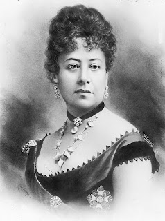
Queen Emma


In 1836, Honolulu wasn’t really a city; it was just a large village with only one main street, King Street, and less than 6,000 people - about 500 were white foreigners.

It was a major port for whaling ships, and as one writer put it, one of the most "unattractive" places in the world.

Emma, the future queen, was born “Emma Naea” in Honolulu on January 2, 1836 to Fanny Kekelaokalani Young, daughter of John Young, King Kamehameha I's counselor, and Kaʻoanaʻeha, Kamehameha's niece. Her father was high chief George Naea.

As was the custom, she was offered to her mother's sister, Grace Kamaikui Rooke and her husband, Dr. T.C.B. Rooke as hānai daughter. Unable to have children of their own, the Rookes adopted Emma.

Emma grew up speaking both Hawaiian and English, the latter “with a perfect English accent.” She began formal schooling at age 5 in the Chief's Children's School, where she was quick and bright in her studies.

At age 13, Dr. Rooke hired an English governess, Sarah Rhodes von Pfister, to tutor young Emma. He also encouraged reading from his extensive library. As a writer, he influenced Emma's interest in reading and books.

At 20, Emma became engaged to the king of Hawai‘i, Alexander Liholiho, (Kamehameha IV,) a 22-year-old who had ascended to the throne in 1855.  The couple had known each other since childhood.

At the engagement party, accusations were made that Emma's Caucasian blood made her not fit to be the Hawaiian queen, and her lineage was not suitable enough to be Alexander Liholiho's bride.

However, the wedding was held as planned however, and the new queen soon became involved in the business of the kingdom, particularly that of saving the Hawaiian people from extinction.

In his first speech as King, Kamehameha IV stated the need for a hospital to treat the native population.  Due to introduced diseases, the Hawaiian population had plummeted since the time of Captain Cook's arrival to 70,000, with extinction a very real possibility.

The treasury was empty, so the king and his queen undertook the mission of soliciting enough funds to establish a proper hospital in Honolulu. Within a month, their personal campaign had raised $13,530, almost twice their original goal.

To recognize and honor Emma's efforts, it was decided to call the new hospital "Queen's."

The King and Queen rejoiced at the birth of their son, Albert Kauikeaouli Leiopapa a Kamehameha, on May 20, 1858. The entire populace welcomed the new heir to the throne with joy, only to be stricken by utter grief four years later when the little boy died suddenly of "brain fever."

Just 15 months later, Alexander Liholiho, (Kamehameha IV,) weakened by chronic asthma, died at age 29.  In her grief, Queen Emma took a new name, Kaleleonalani, which means “flight of the heavenly chiefs.”

To ease her pain, Emma dedicated herself to many worthy causes, among which was organizing a hospital auxiliary of women to help with the ill. She also helped found two schools, St. Andrews Priory in Honolulu and St. Cross on Maui. Her work included the development of St. Andrews Cathedral. She journeyed to England where she and her friend, Queen Victoria, raised $30,000 for the construction or the cathedral.

“Queen Emma, or Kaleleonalani, the widowed queen of Kamehameha IV … refined by education and circumstances … is a very pretty, as well as a very graceful woman. She was brought up by Dr. Rooke, an English physician here, and though educated at the American school for the children of chiefs, is very English in her leanings and sympathies, an attached member of the English Church, and an ardent supporter of the “Honolulu Mission.” Socially she is very popular, and her exceeding kindness and benevolence, with her strongly national feeling as an Hawaiian, make her much beloved by the natives.”  (Bird)

When King Lunalilo died in 1874, Emma became a candidate for the throne (the Kingdom had become a constitutional democracy). Lunalilo had wanted her to succeed him, but he failed to make the legal pronouncement before he died.

An election for a new sovereign was held.  Although she campaigned actively, she lost the throne to David Kalākaua.

Politics was not her strong suit -- humanitarianism was.  Queen Emma was much loved by the people and hundreds of mele have been composed in her honor.  Her humanitarian efforts set an example for Hawaii's royal legacy of charitable bequests.

After her death on April 25, 1885 at age 49, she was given a royal funeral and laid to rest in Mauna ʻAla beside her husband and son.

“She was different from any of her contemporaries. Emma is Emma is Emma. There’s no one like her. A devout Christian who chose to be baptized in the Anglican church in adulthood, and a typically Victorian woman who wore widow’s weeds, gardened, drank tea, patronized charities and gave dinner parties, she yet remained quintessentially Hawaiian.”  (Kanahele)

 “In a way, she was a harbinger of things to come in terms of Hawaii’s multi-ethnic, multi-cultural society. You have to be impressed with her eclecticism — spiritually, emotionally and physically. She was kind of our first renaissance queen."  (Kanahele)

Queen Emma left the bulk of her estate, some 13,000 acres of land on the Big Island and in Waikiki on Oahu, in trust for the hospital that honors her.  (Lots of good information here came from Queen’s Hospital)

The image shows Queen Emma; in addition, I have added some other images in a folder of like name in the Photos section on my Facebook and Google+ pages.

Follow Peter T Young on Facebook  

Follow Peter T Young on Google+  

© 2013 Hoʻokuleana LLC

Wednesday, April 24, 2013

Waikīkī - Kauhale O Hoʻokipa


We are happy to announce that the Hawaiʻi State legislature just adopted a concurrent resolution (passed by the Senate and the House) in support of Native Hawaiian Hospitality Association's (NaHHA,) hard work and efforts as the sponsor for the Waikīkī - Kauhale O Hoʻokipa Scenic Byway.

The Legislature notes that "Waikīkī - Kauhale O Hoʻokipa Scenic Byway is a collaborative effort between the community, business, visitor industry and government to promote and share the special intrinsic qualities of Waikīkī, particularly the role Waikīkī played in Hawaiʻi’s history".

In addition, the Legislature took a strong, affirmative position that it "supports the designation of the Waikīkī - Kauhale O Hoʻokipa as a Hawaiʻi Scenic Byway and National Scenic Byway."

The Hawaii Scenic Byways Program identifies and recognizes:
•  roads that “tell a story” that is special;
•  roads with outstanding scenic, cultural, recreational, archaeological, natural and historic qualities; and
•  roads that will benefit from a coordinated strategy for tourism and economic development

The Scenic Byways program serves to identify "Intrinsic Qualities" along the corridor; these include Scenic, Natural, Historic, Cultural, Archaeological and Recreational.

These intrinsic qualities break into two clusters:
"Land" (Scenic, Natural and Recreational,) and
"People" (Historic, Cultural and Archaeological)

Sites and Stories of Waikīkī, as illustrated through its Intrinsic Qualities, help tell the stories of the Land (‘Āina) and its People from the earliest beginnings of Hawai‘i to today.  Waikīkī - Kauhale O Hoʻokipa will be incorporating several core story themes:
•  Royal Residences
•  Visitor Industry
•  Military
•  Natural/Geologic
•  Socio-Economic-Political
•  Side Trips

We have been retained by NaHHA to help them with this process.

You can see some of our other activities by clicking here.

Feel free to "Like" us, if you like.

You may also visit us at our home page by clicking here.

Betsey Stockton


Born in 1798 in Princeton, New Jersey, as a slave owned by the family of Robert Stockton, Esq., Betsey Stockton was presented as a gift to the Stockton's eldest daughter and her husband, the Reverend Ashbel Green (who was then the President of Princeton College (later known as Princeton University.))

Although masters did not typically favor educating their slaves beyond proficient training as domestic nurse, seamstress and cook, Green gave her books and encouraged her to use the family library. She later attended evening classes at Princeton Theological Seminary.

In September 1816, Betsey’s application for admission to the First Presbyterian Church in Princeton was formally approved.  Around 1817, Ashbel Green freed her.

Stockton often spoke to Green about her wish to journey abroad, possibly to Africa, on a Christian mission. Green introduced her to Charles S Stewart, a young missionary, newly ordained in 1821, who was about to be sent by the American Board of Commissioners for Foreign Missions (ABCFM) to Hawaiʻi.

Through a special agreement between Green, the Stewarts and the ABCFM, Stockton joined the mission both as a domestic in the Stewart household and was commissioned by the ABCFM as a missionary.

She became the first single American woman sent overseas as a missionary.

Her contract with the Board and with the Stewarts said that she went "neither as an equal nor as a servant, but as a humble Christian friend" to the Stewarts, and provided that she was not to do more than an equal share of menial duties which might "prevent her being employed as a teacher of a school".

In November 1822, Stockton, the Stewarts and the other missionaries in the 2nd Company set sail on the 'Thames' from New Haven, Connecticut for the Hawaiian Islands.

On April 24, 1823, "we saw and made Owhyhee (Hawaiʻi). At the first sight of the snow-capped mountains, I felt a strange sensation of joy and grief. It soon wore away, and as we sailed slowly past its windward side, we had a full view of all its grandeur. The tops of the mountains are hidden in the clouds, and covered with perpetual snow. We could see with a glass the white banks, which brought the strong wintry blasts of our native country to our minds so forcibly, as almost to make me shiver."  (Betsey Stockton Journal)

Upon her arrival, Stockton became the first known African American woman in Hawaiʻi.

Intelligent, industrious and frugal, she was aptly described as a devoted Christian, not only because of her constant attendance at church and her faith in God, but also because she supported the interests of the church, secured clothes for her students, and helped to heal the sick while continuing her domestic work to help the Stuarts.  (Jackson)

"On Saturday, the 10th of May (1823,) we left the ship, and went to the mission enclosure at Honoruru. We had assigned to us a little thatched house in one corner of the yard, consisting of one small room, with a door, and two windows - the door too small to admit a person walking in without stooping, and the windows only large enough for one person to look out at a time. … The family all eat at the same table, and the ladies attend to the work by turns. Mrs. Stewart and myself took each of us a day separately."  (Betsey Stockton Journal)

"On the 26th of May (1823) we heard that the barge (Cleopatra's Barge, or "Haʻaheo o Hawaiʻi," Pride of Hawaiʻi) was about to sail for Lahaina, with the old queen (Keōpūolani) and princess (Nāhiʻenaʻena;) and that the queen was desirous to have missionaries to accompany her … A meeting was called to consult whether it was expedient to establish a mission at Lahaina. The mission was determined on, and Mr. S. (Stewart) was appointed to go: he chose Mr. R. (Richards) for his companion … On the 28th we embarked on the mighty ocean again, which we had left so lately."  (Betsey Stockton Journal)

Per the requests of the chiefs, the American Protestant missionaries, at that time, were typically teaching their own children and the children of the Hawaiian chiefs.

"Now the chiefs have expressed their determination to have instruction in reading and writing extended to the whole population and have only been waiting for books, and an increase in the number of suitably qualified native teachers, to put the resolution, as far as practical, into effect.  A knowledge of this having reached some of the makaainana, or farmers of Lahaina ... application was made by them to us for books and slates, and an instructor; and the first school, consisting of about thirty individuals, ever formed among that class of people, has, within a few days, been established in our enclosure, under the superintendence of B (Betsey Stockton), who is quite familiar with the native tongue."  (Charles Stewart Journal, August 1824)

In 1823, Kalākua Kaheiheimālie (ke Aliʻi Hoapili wahine, wife of Governor Hoapili) offered the American missionaries a tract of land on the slopes surrounding Puʻu Paʻupaʻu for the creation of a school.

Stockton founded a school for makaʻāinana (common people) including the women and children.  The school was situated on what is now Lahainaluna School (and some suggest it served as the initial basis for that school.)

Stockton's school was commended for its teaching proficiency, and later served as a model for the Hilo Boarding School and also for the Hampton Institute in Virginia, a historic Black college in Virginia established after the Civil War (founded by General Samuel C. Armstrong (son of missionary Richard Armstrong, former Pastor at Kawaiahaʻo Church.))  (Kalākaua visited Hampton Normal and Agricultural School - later known as Hampton Institute on one of his trips to the continent.)

Because of the serious illness of Mrs. Harriet Stewart, the Stewarts decided to return to Cooperstown, New York, after two and a half years in Hawaiʻi.  Stockton accompanied them; leaving native Hawaiian teachers she had trained to take her place.

Stockton left Hawaiʻi in 1825, returning to the continent where she was assigned to teach Native American children in Canada.  Then, Stockton returned to Princeton in 1835, living in a small house on Witherspoon Street, which was primarily an African American neighborhood.

Stockton was instrumental in the founding of the Witherspoon Street Presbyterian Church, originally called the First Presbyterian Church of Color of Princeton. She also began teaching African American children in a public school in Princeton in 1837, which she continued to do for several years.

She spent the rest of her life in Princeton working on behalf of its African American and white residents to enrich the lives of the members of the local African American community.

Betsey Stockton began life as a slave, and went on to become a schoolteacher, medical nurse and missionary; she died in her hometown of Princeton, New Jersey in October 1865.

The image shows Betsey Stockton; in addition, I have added some other images in a folder of like name in the Photos section on my Facebook and Google+ pages.

Follow Peter T Young on Facebook  

Follow Peter T Young on Google+  

© 2013 Hoʻokuleana LLC

Tuesday, April 23, 2013

Matson Navigation Company


Born in Sweden, Captain William Matson (1849–1917) arrived in San Francisco in 1867, at the age of 16.  There, he began sailing in San Francisco Bay and northern California rivers.

Captain Matson became acquainted with the JD Spreckels family and was asked to serve as skipper on the Spreckels yacht, Lurline.  The Spreckels family later assisted Captain Matson in obtaining his first ship, the Emma Claudina.

In 1882, when Matson sailed his three-masted schooner Emma Claudina from San Francisco to Hilo, carrying 300 tons of food, plantation supplies and general merchandise, Matson Navigation Company started its long association with Hawai‘i.

That voyage launched a company that has been involved in such diversified interests as oil exploration, hotels and tourism, military service during two world wars and even briefly, the airline business.  Matson's primary interest throughout, however, has been carrying freight between the Pacific Coast and Hawai‘i.

In 1887, Captain Matson sold the Emma Claudina and acquired the 150-foot brigantine Lurline from his employer, JD Spreckels - this was the first of several famous Matson vessels to bear the name Lurline.

Matson met his future wife, Lillie Low, on a yacht voyage he captained to Hawai‘i; the couple named their daughter Lurline Berenice Matson.

As the Matson fleet expanded, new vessels introduced some dramatic maritime innovations. The bark ‘Rhoderick Dhu’ was the first ship to have a cold storage plant and electric lights. The first Matson steamship, the ‘Enterprise,’ was the first offshore ship in the Pacific to burn oil instead of coal.

Increased commerce brought a corresponding interest in Hawai‘i as a tourist attraction. The second Lurline, with accommodations for 51 passengers, joined the fleet in 1908. The 146-passenger ship SS Wilhelmina followed in 1910, rivaling the finest passenger ships serving the Atlantic routes.

More steamships continued to join the fleet. When Captain Matson died in 1917 at 67, the Matson fleet comprised 14 of the largest, fastest and most modern ships in the Pacific passenger-freight service.

When World War I broke out, most of the Matson fleet was requisitioned by the government as troopships and military cargo carriers. Other Matson vessels continued to serve Hawai‘i's needs throughout the war. After the war, Matson ships reverted to civilian duty and the steamers Manulani and Manukai were added to the fleet - the largest freighters in the Pacific at that time.

The decade from the mid-1920s to mid-1930s marked a significant period of Matson expansion.  In 1925, the company established Matson Terminals, Inc., a wholly owned subsidiary, to perform stevedoring and terminal services for its fleet.

With increasing passenger traffic to Hawai‘i, Matson built a world-class luxury liner, the SS Malolo, in 1927. At the time, the Malolo was the fastest ship in the Pacific, cruising at 22 knots. Its success led to the construction of the luxury liners Mariposa, Monterey and Lurline between 1930 and 1932.

Matson’s famed “white ships” were instrumental in the development of tourism in Hawai‘i.  In addition, beginning in 1927, with the construction of the Royal Hawaiian Hotel, Matson’s Waikīkī hotels provided tourists with luxury accommodations both ashore and afloat.

Immediately after the December 7, 1941 attack on Pearl Harbor, the passenger liners Lurline, Matsonia, Mariposa and Monterey, and 33 Matson freighters were called to military service.

Matson, as General Agent for the War Shipping Administration, was given the responsibility for manning, provisioning, maintaining and servicing an important part of the government’s rapidly expanding fleet of cargo vessels. Matson was soon operating a fleet of more than one hundred vessels.

The post-war period for Matson was somewhat difficult. The expense of restoration work proved to be very costly and necessitated the sale of the Mariposa and Monterey, still in wartime gray. In 1948, the Lurline returned to service after a $20-million reconversion.

Two new Matson hotels were built on Waikiki in the 1950s, the Surfrider in 1951 and the Princess Kaʻiulani in 1955. In 1955, Matson undertook a $60-million shipbuilding program which produced the South Pacific liners Mariposa and Monterey, and the rebuilt wartime Monterey was renamed Matsonia and entered the Pacific Coast and Hawai‘i service.

On August 31, 1958, Matson's SS Hawaiian Merchant departed San Francisco Bay carrying 20 24-foot containers on deck. The historic voyage marked the beginning of an ambitious containerization program that achieved tremendous gains in productivity and efficiency from the age-old methods of break-bulk cargo handling.

The container freight system that Matson introduced to Hawai‘i in 1958 was a product of years of careful research and resulted in the development of a number of industry innovations that became models worldwide.  Containerization brought the greatest changes to water transportation since steamships replaced sailing vessels.

Concurrently, shore side innovations were introduced, including the world's first A-frame gantry crane, which was erected in 1959 in Alameda, California and became the prototype for container cranes.

In 1959 (the year Hawai‘i entered statehood and jet airline travel was initiated to the State,) Matson sold all of its Hawaiʻi hotel properties to the Sheraton hotel chain.

The image shows the three-masted schooner Emma Claudina that entered Hilo Bay in the early dawn of April 23, 1882 – setting the stage for a long relationship between Matson Navigation Company and Hawai‘i.

In addition, I have added other images of Matson’s ships and related items in a folder of like name in the Photos section on my Facebook and Google+ pages.


Monday, April 22, 2013

Sustainability


I sometimes get tired of that term; it gets to be overused and overplayed.

How about simply calling it doing the right things for the right reasons?

Our existence here is not about us and it’s not about now.

As Isaac Newton suggested, we are standing on the shoulders of those who came before us … that gives us the responsibility to pass on the legacy to those who follow.

Others before us planted the seed; it is our responsibility to nurture its growth, so those in the future may enjoy its fruit ... and sow the seeds for yet future generations.

Our responsibility is to move from the “what’s in it for me” and “I got mine” mentalities, toward a long-term frame of reference and a focus on others (those we will never meet,) rather than ourselves.

That’s what sustainability means to me.  Happy Earth Day.

© 2013 Hoʻokuleana LLC

Sunday, April 21, 2013

Telling Time


Does anybody really know what time it is?  Does anybody really care?

The answer to both is Yes … and Kauaʻi, Hawaiʻi has the distinction of being one of only two official Time broadcast points in the United States (the other is in Fort Collins, Colorado.)

At first, I thought “Time” was a pretty simple thing.  Oh yeah, every now and then we need to mentally add or subtract an extra hour between points on the continent – and most folks there need to adjust for “Daylight” or not – but in looking into the Kauaʻi operation, I quickly learned that there are many variables of “Time.”

OK, let’s fast forward past the daylight-darkness, sundial, wind-up and quartz watch timing eras … nowadays, transportation, communication, financial transactions, manufacturing, electric power and many other technologies have become dependent on accurate clocks; folks need to be more accurate than being “about” a certain time.

In addition, some folks need time referenced to the Earth’s rotation for applications such as celestial navigation, satellite observations of the Earth and some types of surveying.  For those folks, Time relative to the motion of the Earth is more important than the accuracy of the atomic clock (even though Earth time fluctuates by a few thousandths of a second a day.)

For the rest of us, highly accurate atomic clocks and the agreement in 1967 on what a “second” is (the duration of 9,192,631,770 cycles of the radiation associated with a specified transition of the cesium atom) led to a compromise time scale of the Coordinated Universal Time (UTC.)

The National Institute of Standards and Technology (NIST - an agency of the US Department of Commerce) laboratories in Boulder, Colorado does the computing for us and even broadcasts the UTC(NIST) via various means.  (UTC(NIST) is the US national standard for measurements of time-of-day, time interval and frequency.

Here’s the official statement on what they do: “UTC(NIST) is the coordinated universal time scale maintained at NIST. The UTC(NIST) time scale comprises an ensemble of cesium beam and hydrogen maser atomic clocks, which are regularly calibrated by the NIST primary frequency standard. The number of clocks in the time scale varies, but is typically around ten.”

“The outputs of the clocks are combined into a single signal by using a weighted average. The most stable clocks are assigned the most weight. The clocks in the UTC(NIST) time scale also contribute to the International Atomic Time (TAI) and Coordinated Universal Time (UTC).”

“UTC(NIST) serves as a national standard for frequency time interval, and time-of-day. It is distributed through the NIST time and frequency services and continuously compared to the time and frequency standards located around the world.”

Whoa, that’s waaay more information than I needed; … and, I think you are confusing me with someone who cares.  (Short answer, those guys “keep” the time.)  OK, let’s move on.

If you really want to know what Time it is, go to http://nist.time.gov , select your desired time zone in the US and the time will be displayed for you.

Or, call to hear the “Time” broadcasts by dialing (303) 499-7111 for WWV (Colorado) and (808) 335-4363 for WWVH (Hawaiʻi).

These are not toll-free numbers; callers outside the local calling area are charged for the call at regular long-distance rates.  The telephone time-of-day service is used to synchronize clocks and watches and for the calibration of stopwatches and timers. It receives about 2,000 calls per day.

OK, back to Kauaʻi.

At Kokole Point at Mānā, Kauaʻi, the NIST radio station WWVH broadcasts time and frequency information 24 hours per day, 7 days per week to listeners worldwide.  (These are the guys who “tell” the time.)

The information broadcast by WWVH includes time announcements, standard time intervals, standard frequencies, UT1 time corrections (time derived by astronomers who monitor the speed of the Earth's rotation,) a BCD time code (time data is coded binary coded decimal (BCD) digits in the form HH:MM:SS:FF,) geophysical alerts, marine storm warnings and Global Positioning System (GPS) status reports.

Voice announcements are made from WWVH once every minute.  The announced time is "Coordinated Universal Time" (UTC).   Coordination with the international UTC time scale keeps NIST time signals in close agreement with signals from other time and frequency stations throughout the world.

UTC differs from local time by the number of time zones between your location and the zero meridian (which passes through Greenwich, England.) (In Hawaiʻi, it’s UTC – 10 (the online and telephone time broadcasts are calibrated for Hawaiʻi.))

UTC is a 24-hour clock system.  When local time changes from Daylight Saving to Standard Time, or vice versa, UTC does not change. However, the difference between UTC and local time may change by 1-hour.  UTC runs at an almost perfectly constant rate, since its rate is based on cesium atomic frequency standards.

In addition to the time-related data, NOAA uses WWVH to broadcast geophysical alert messages that provide information about solar terrestrial conditions. Marine storm warnings are broadcast for the Atlantic and Pacific oceans and the Gulf of Mexico. The National Weather Service provides the storm warning information.  (This information is broadcast at specific time intervals in each hour.)

Another critical function of the WWV system (especially for Hawaiʻi) is keeping the clocks on the GPS satellites in sync.  GPS technology requires very accurate timekeeping as the difference in radio signal arrival is a big part of fixing your location.  Without WWVH, the GPS system would drift off and lots of transportation and related functions would be affected (airplanes, ships, self-driving cars, etc.)

WWVH began operation on November 22, 1948 at Kihei on the island of Maui (the site now houses the Hawaiian Islands Humpback Whale National Marine Sanctuary offices.)   In July 1971, the station moved to its current location, near Kekaha, Kauaʻi.

For those wondering why these two facilities, that are west of the Mississippi River, have call signs that start with “W” (typically, station call signs west of the Mississippi start with “K” and those east start with “W,”) the time station’s early location was in Washington, DC (May 1920) – when it moved to Fort Collins (1966,) it kept the call sign.  For consistency, Kauaʻi followed the call sign pattern.

The image shows the WWVH facility on Kauaʻi; in addition, I have added other related images in a folder of like name in the Photos section on my Facebook and Google+ pages.

Follow Peter T Young on Facebook  

Follow Peter T Young on Google+  

© 2013 Hoʻokuleana LLC

Saturday, April 20, 2013

Kalo (Taro)


Hawaiian traditions describe the birth of the islands and the life that exists on them in terms of genealogical accounts.

All natural forms of the environment are believed to be embodiments of gods and deities.  From godly forces the Hawaiian Islands are born of Wākea (the expanse of the sky‐father) and Papahānaumoku (Papa who gave birth to the islands).

Wākea and Papa are credited for being the parents of the first man, Hāloa, the ancestor of all people.  Commoners and aliʻi were all descended from the same ancestors, Wākea (sky father) and Papa (earth mother.)

It is from this genealogical line that Hawaiians address the environment and it forms the basis of the Hawaiian system of land use.

“The first born son of Wākea was of premature birth (keiki alualu) and was given the name Hāloa-naka. The little thing died, however, and its body was buried in the ground at one end of the house.  After a while from the child’s body shot up a taro plant, the leaf of which was named lau-kapa-lili, quivering leaf; but the stem was given the name Hāloa.  After that another child was born to them, whom they called Hāloa, from the stalk of the taro. He is the progenitor of all the peoples of earth.” (Malo)

“The first Hāloa, born to Wākea and Ho‘ohokukalani, became the taro plant. His younger brother, also named Haloa, became the ancestor of the people.  In this way, taro was the elder brother and man the younger--both being children of the same parents.”

“Because our chiefs were of the senior line, they were referred to in respect and affection as “kalo kanu o ka aina” (The taro grown in the homeland) by the junior branches of the family.”(Handy-Pukui)

In pre-Captain Cook times, taro played a vital role in Hawaiian culture. It was not only the Hawaiians’ staple food but the cultivation of kalo was at the very core of Hawaiian culture and identity.

The early Hawaiians probably planted kalo in marshes near the mouths of rivers. Over years of progressive expansion of kalo lo‘i (flooded taro patches) up slopes and along rivers, kalo cultivation in Hawai‘i reached a unique level of engineering and sustainable sophistication.

The Hawaiian concept of family, ‘ohana, is derived from the word ‘ohā (Fig., offspring, youngsters,) the axillary shoots of kalo that sprout from the main corm, the makua (parent.)  Huli, cut from the tops of mauka, and ‘ohā are then used for replanting to regenerate the cycle of kalo production.

Kalo lo‘i systems are typically a set of adjoining terraces that are typically reinforced with stone walls and soil berms. Wetland taro thrives on flooded conditions, and cool, circulating water is optimal for taro growth, thus a system may include one or more irrigation ditches, or ‘auwai, to divert water into and out of the planting area.  (McElroy)

In 6 to 12 months, depending upon plant variety along with soil and water conditions, the taro is generally ready to harvest. Each parent tuber produces from two to 15 ʻohā, side tubers of corms, up to 6 inches in diameter.

Kalo patches are variously named on the basis of size, shape, planting method and other factors. Mo‘o ai are narrow strips of planted kalo, much longer than they are wide. Mo‘o kaupapa lo‘i are long rows of lo‘i or wet kalo patches. Other types of wet planting mounds include pu‘epu‘e hou and kipi or kipikipi. Of the wetland methods, lo‘i was most frequently occurring form.

Taro or Kalo has been a traditional form of food sustenance and nutrition, particularly in ancient Hawaiian culture.  Reportedly, it is the world’s fourteenth most-consumed vegetable.  All parts of the plant are eaten, including poi, table taro (the cooked corm,) taro chips and luau leaf.

Kalo starch is one of the most nutritious, easily digested food.  Kalo corms are high in carbohydrate in the form of starch and low in fat and protein, similar to many other root crops.

The starch is 98.8 percent digestible, a quality attributed to its granule size, which is a tenth that of potato, making it ideal for people with digestive difficulties.

The corm is an excellent source of potassium (higher than banana), carbohydrate for energy and fiber. When eaten regularly, kalo corm provides a good source of calcium and iron. Kalo leaves (lū‘au leaves) are eaten as a vegetable.

The staple of the ancient Hawaiian people, poi, is a gentle food, hypoallergenic, gluten free and easily digestible. It has saved the lives of babies who have been allergic to everything else. Poi is just about for everyone - from the health-challenged to the super-fit endurance athlete. (Bishop Museum)

Kalo, like other plants in its family, is considered poisonous when raw because its tissues contain an acrid component; thorough steaming or boiling eliminates this and allows it to be eaten.

It is estimated that at the peak of kalo production, areas under its cultivation covered more than 20,000-acres (about 31 square miles) over six islands.

Since the early to mid-1800s, kalo cultivation and the demand for kalo has markedly declined, and many of the ceremonial, medicinal and upland kalo cultivars became neglected and were lost.

In the last 200 years, Waipi‘o has experienced many changes: new ownership of the land, assimilation of other ethnic groups into the indigenous Hawaiian population and the shift from subsistence taro farming to market production.  (UH)

In 1900, it was estimated that about 1,280 acres were being used for kalo production.  By 1907, rice had become a major crop, occupying about 10,000 acres.

At that time, Chinese farmers were growing about half the kalo crop and milling 80 percent of the poi. By 1937, the major kalo growers were Japanese.

With the outbreak of World War II in 1941, demand for kalo declined and production dropped to 920 acres.  Today, less than 400 acres of kalo are planted.

The 21st Annual East Maui Taro Festival will be held in Hana, Maui, 9 am – 5 pm, April 20-21, 2013, Hana Ballpark - Hauoli Road & Uakea Street.  Hawaiian entertainment & Hula, 20 Food Booths, 50 Arts & Crafts Booths, an Info Tent for non-profits, an Ag Tent & Farmers Market and hands-on Cultural demos such as poi-pounding, kapa cloth making, creating Hawaiian musical instruments, lauhala weaving. Family-friendly and no admission charge.

The image shows a couple of men pounding poi.   (Lots of information here from CTAHR.)   In addition, I have added some other related images in a folder of like name in the Photos section on my Facebook and Google+ pages.

Follow Peter T Young on Facebook  

Follow Peter T Young on Google+  

© 2013 Hoʻokuleana LLC

Friday, April 19, 2013

Contact


"... at 5 o'clock we arrived there and saw a number of People, I believe between 2 and 300 ... we still continued advancing, keeping prepared against an attack tho' without intending to attack them ... they fired one or two shots, upon which our Men without any orders rushed in upon them, fired and put 'em to flight; several of them were killed".  (Diary of Lt. John Barker, Library of Congress)

On April 19, 1775, the Battles of Lexington and Concord were the first military engagements of the American Revolutionary War.  The battles marked the outbreak of open armed conflict between the Kingdom of Great Britain and its thirteen colonies of British North America.

The first shot (“the shot heard round the world”) was fired just as the sun was rising at Lexington. The American militia were outnumbered and fell back; and the British regulars proceeded on to Concord.

Following this, the Continental Congress adopted the Declaration of Independence and it was signed by 56-members of the Congress (1776.)

The next eight years (1775-1783) war was waging on the eastern side of the continent.  The main result was an American victory and European recognition of the independence of the United States.

The formal end of the war did not occur until the Treaty of Paris and the Treaties of Versailles were signed on September 3, 1783 and recognized the sovereignty of the United States over the territory bounded roughly by what is now Canada to the north, Florida to the south, and the Mississippi River to the west.

The last British troops left New York City on November 25, 1783, and the US Congress of the Confederation ratified the Paris treaty on January 14, 1784.

It was the turning point in the future of the continent and an everlasting change in the United States.

At this same time, there was a turning point in the future of the Islands.

In the dawn hours of January 18, 1778, on his third expedition, British explorer Captain James Cook on the HMS Resolution and Captain Charles Clerke of the HMS Discovery first sighted what Cook named the Sandwich Islands (that were later named the Hawaiian Islands.)

Hawaiian lives changed with sudden and lasting impact, when western contact changed the course of history for Hawai‘i.

Cook continued to sail along the coast searching for a suitable anchorage.  His two ships remained offshore, but a few Hawaiians were allowed to come on board on the morning of January 20, before Cook continued on in search of a safe harbor.

On the afternoon of January 20, 1778, Cook anchored his ships near the mouth of the Waimea River on Kauaʻi’s southwestern shore.  After a couple of weeks, there, they headed to the west coast of North America.

After the West Coast, Alaska and Bering Strait exploration, on October 24, 1778 the two ships headed back to the islands; they sighted Maui on November 26, circled the Island of Hawaiʻi and eventually anchored at Kealakekua Bay on January 17, 1779.

At the time of Cook’s arrival (1778-1779), the Hawaiian Islands were divided into four kingdoms: (1) the island of Hawaiʻi under the rule of Kalaniʻōpuʻu, who also had possession of the Hāna district of east Maui; (2) Maui (except the Hāna district,) Molokaʻi, Lānaʻi and Kahoʻolawe, ruled by Kahekili; (3) Oʻahu, under the rule of Kahahana; and at (4) Kauaʻi and Niʻihau, Kamakahelei was ruler.

At that time of Cook’s arrival, Kalaniʻōpuʻu was on the island to Maui to contend with Kahekili, king of Maui. The east side of Maui had fallen into the hands of Kalaniʻōpuʻu and Kahekili was fighting with him to gain control.

Kalaniʻōpuʻu returned to Hawaiʻi and met with Cook on January 26, 1779, exchanging gifts, including an ʻahuʻula (feathered cloak) and mahiole (ceremonial feather helmet.)   Cook also received pieces of kapa, feathers, hogs and vegetables.

In return, Cook gave Kalaniʻōpuʻu a linen shirt and a sword; later on, Cook gave other presents to Kalaniʻōpuʻu, among which one of the journals mentions "a complete Tool Chest."

Throughout their stay the ships were plentifully supplied with fresh provisions which were paid for mainly with iron, much of it in the form of long iron daggers made by the ships' blacksmiths on the pattern of the wooden pāhoa used by the Hawaiians.  The natives were permitted to watch the ships' blacksmiths at work and from their observations gained information of practical value about the working of iron. (Kuykendall)

After a month's stay, Cook got under sail again to resume his exploration of the Northern Pacific. Shortly after leaving Hawaiʻi Island, the foremast of the Resolution broke and the ships returned to Kealakekua Bay for repairs.

On February 14, 1779, at Kealakekua Bay, some Hawaiians took one of Cook's small boats. He attempted to take hostage the King of Hawaiʻi, Kalaniʻōpuʻu. The Hawaiians prevented this and Cook and some of his men were killed.  Clerke took over the expedition and they left.

After the departure of the Resolution and Discovery, Kalaniʻōpuʻu left the bay and passed to Kaʻū, the southern district of Hawaiʻi, having in his charge the young Kaʻahumanu. He died shortly thereafter.  (Bingham)

Following Kalaniʻōpuʻu’s death in 1782, the kingship was inherited by his son Kīwalaʻō; Kamehameha (Kīwalaʻō's cousin) was given guardianship of the Hawaiian god of war, Kukailimoku.

Dissatisfied with subsequent redistricting of the lands by district chiefs, civil war ensued between Kīwalaʻō's forces and the various chiefs under the leadership of Kamehameha. At the Battle of Mokuʻōhai (just south of Kealakekua) Kīwalaʻō was killed and Kamehameha attained control of half the Island of Hawaiʻi.

Kamehameha, through the assistance of the Kona "Uncles" (Keʻeaumoku, Kekūhaupiʻo, Keaweaheulu, Kameʻeiamoku & Kamanawa (the latter two ended up on the Island’s coat of arms;)), succeeded, after a struggle of more than ten years, in securing to himself the supreme authority over that island.

After further conquest Kamehameha took all of the islands, except Kauaʻi and Niʻihau – of which he gained control through negotiation in 1810.  (And, a little later, back on the continent, the US and Britain battled in the War of 1812.)

It’s interesting how dynamic changes (each involving Great Britain) were occurring at the same time, at relatively opposite ends of the globe.

The image shows Kalaniʻōpuʻu welcoming Cook at Kealakekua, as depicted by Herb Kane.    In addition, I have included other images in a folder of like name in the Photos section on my Facebook and Google+ pages.

Follow Peter T Young on Facebook  

Follow Peter T Young on Google+  

© 2013 Hoʻokuleana LLC

Thursday, April 18, 2013

What Had Long Been Feared


“What has long been feared by some, and considered a certain event by others, has happened. The Chinese quarter of Honolulu has been devastated by a fire, that, gaining headway in the dense aggregation of wooden buildings, was quickly beyond control and sweeping in all directions.” (Daily Bulletin – April 19, 1886)

It started on April 18, 1886.  A few minutes before 1 o'clock the fire started in a Chinese cook house on the corner of Hotel street and Smith's lane. It started accidentally by the owner of the premises in lighting his fire for cooking.

“Although not a breath of wind stirred ... quicker than can be told the fire was leaping from roof to roof, gliding along verandahs, entwining itself about pillars and posts, festooning doors and windows . ... In the calm the smoke rose in a vast volume . . . . Both [Smith and Hotel] were soon lanes of fire.”  (Daily Bulletin – April 19, 1886)

After a seven-hour ordeal-about half of it in darkness-the walls of the last building to collapse fell in. It was exactly 11:20 and the place was the makai side of the King Street bridge leading across to the Palama district.

As the embers cooled, tempers flared.

Hawaiians of Chinatown, especially around the ʻEwa side of Maunakea Street, where they had been the greatest losers, were bitter.  They blamed it all on the Chinese.

By midnight a mob of perhaps 3,000 crowded around the King Street bridge and back to the Chinese theater. As Hawaiians itched for a fight, things could get nasty – fortunately, cooler heads prevailed and while skirmishes occurred, a full-on riot was avoided.

Honolulu’s Chinatown, then and now, is the approximate 36-acres on the ʻEwa side of Downtown Honolulu.  It developed into a Chinese dominated place, following the in-migration of Chinese to work on the sugar plantation, starting in 1852.

Between 1852 and 1876, 3,908 Chinese were imported as contract laborers, compared with only 148 Japanese and 223 South Sea Islanders. Around 1882, the Chinese in Hawaii formed nearly 49% of the total plantation working force, and for a time outnumbered Caucasians in the islands.

It had been noted, according to one observer in 1882, for the fact that the great majority of its business establishments "watchmakers’ and jewelers’ shops, shoe-shops, tailor shops, saddle and harness shops, furniture-shops, cabinet shops and bakeries, (were) all run by Chinamen with Chinese workmen."

By 1884, the Chinese population in Honolulu reached 5,000, and the number of Chinese doing plantation work declined.   As a group they became very important in business in Hawaii, and 75% of them were concentrated in Chinatown where they built their clubhouses, herb shops, restaurants, temples and retail stores.

By 1886, there were 20,000 people living in the area between Nuʻuanu Stream, Nuʻuanu Avenue, Beretania Street and Honolulu Harbor.

Most of the structures were one- and two-story wooden shacks crammed with people, animal and pests. Chinatown had a poor water supply system and no sewage disposal.

Although the fire intensified anti-Chinese feeling, this group had long been under attack. During the 1880s, spurred by what was considered an alarming influx, the Hawaiian government had limited - and for a time halted - their coming.

The year before the fire, massive Japanese immigration started. It had been conceived and encouraged not only to man plantation fields, but also to provide a counterbalance to the Chinese.

The 1886 blaze destroyed eight blocks of Chinatown. While the government soon after established ordinances to widen the narrow streets and limit building construction to stone or brick, nothing was enforced. More ramshackle buildings went up, laying the groundwork for future disaster and disease.

The 1886 fire started at the corner of Hotel and Smith Streets.

They rebuilt.

In 1900, fire struck again.  However, in 1900, the Board of Health intentionally set “sanitary” fires to prevent further spread of the bubonic plague.  Those got out of control.

The 1900 fire caused the destruction of all premises bounded by Kukui Street, River Street, Queen Street (presently Ala Moana Boulevard) and Nuʻuanu Avenue.

Today, the majority of buildings in Chinatown date from 1901 with very few exceptions which escaped the January 20, 1900 fire.

The image shows the aftermath of the 1866 Chinatown fire.   In addition, I have added other images in a folder of like name in the Photos section on my Facebook and Google+ pages.

Follow Peter T Young on Facebook  

Follow Peter T Young on Google+  

© 2013 Hoʻokuleana LLC

Wednesday, April 17, 2013

Did The Early Hawaiians Have Iron?


Hawaiian stone tools came in a variety of shapes and sizes, and likewise served a variety of needs.  They were traditionally used to scrape, chop, carve, chisel, gouge, perforate and strip.

Stone tools for food-related uses include the poi pounder (used to crush taro and pounded into poi) and mortars & pestles (mortar bowls and stick-shaped pestles crushed seaweed, nuts, leaves and other products used for food, dyes and medicines.)

Other stone tools eased work, such as adzes (smaller ones to slice like a knife; larger ones to carve wood for canoes or idols, as well as to fell trees, dig, scrape, chip or strip.)

Stone tools also assisted in fishing; stone components were used in lures to catch many types of fish and squid.  In addition to use in making weapons, stone tools were shaped into clubs, axes, sling stones and other lethal weapons.

We are generally aware of the extensive use and nature of stone tools that the Hawaiians had and used.  But, did they also have and use iron tools - if so, how did they get them?

It turns out iron knives were found in the hands of Hawaiians on Kauaʻi on Captain Cook's first visit in 1778.  Iron, crafted into various shapes, was observed on other islands, as well.

Cook noted that the people he met on Kauaʻi were not “acquainted with our commodities, except iron; which however, it was plain, they had … in some quantity, brought to them at some distant period. ... They asked for it by the name of hamaite.”

It is interesting to note that a Spanish word for iron ore is “Hematitas”.  … Hmmm.

Journals and other accounts by Cook and his officers aboard the Discovery and Resolution, note they observed five pieces of iron.

Of these, the two iron skewers or daggers seen at Maui are believed to have been ship spike nails that they reshaped.

A third piece was a dagger made from a ship's bolt which was floated in wreckage to Kauaʻi about October, 1778.

Cook's vessels were at Kauai only a few days in January 1778. When they returned thirteen months later, Samwell and Edgar observed that the Hawaiians had made a dagger from an iron bolt which had been drifted ashore with wreckage five months before.

Edgar remarked: "It was very well beat out into the form of their own wooden daggers." The Hawaiian wooden dagger, as then described, was pointed at one end and, at the other, perforated for a cord for attachment to the wrist.   (Stokes)

Edgar continued: "we saw a great many daggers beat out of our long spike nails we left here last year."  (Stokes)

Crew journals also note two knives, which have subsequently been identified as Japanese.  One was a fish knife, always carried on Japanese sampans; the other was a fish and vegetable knife, generally carried on sampans.

Captain Clerke's record (Jan. 23, 1778) notes, "This morning one of the midshipmen purchased of the natives a piece of iron lashed into a handle for a cutting instrument; it seems to me a piece of the blade of a cutlass; it has by no means the appearance of a modern acquisition; it looks to have been a good deal used and long in its present state; the midshipman … demanded of the man where he got it; the Indian pointed away to the SE ward, where he says there is an island called Tai, from whence it came."  (Stokes)

On the second visit of the ships (1779), Ms. W Bayly ascertained that all the iron seen in the hands of the Kauaʻi natives had floated ashore in wreckage, a statement which Edgar also made on his second visit after a close enquiry of one of the chiefs.

Referring back to the midshipman's information, it may be noted that there is no island named Tai to the south-east of Waimea, Kauai, where the matter was discussed, and since tai (kai) is the term for "sea" and the current sweeps up to Waimea from the south-east, it therefore appears that the implement was floated in, from the sea.

It turns out that among practically all the Polynesians, as recorded by the European voyagers, iron was immediately recognized and was by far the most desired commodity which the foreigners could supply.

When Cook returned to Hawaiʻi the ships were supplied with fresh provisions which were paid for mainly with iron, much of it in the form of iron daggers made by the ships' blacksmiths on the pattern of the wooden pāhoa used by the Hawaiians. The natives were permitted to watch the ships' blacksmiths at work and from their observations gained information of practical value about the working of iron. (Kuykendall)

This apparent widespread knowledge of iron might imply a common and ancient Polynesian acquaintance with the metal.

A fair conclusion would be that the Hawaiians (and probably all other Polynesians) were not iron smelters, and their acquaintance with iron was limited to the finished material made by other people.

So, it appears evident, before Cook's contact with the islands, the Hawaiian already had, used and wanted more iron - to make tools and weapons (principally to shape into knives.)

In answering the obvious follow-up question - Where did it come from? - we need simply recall our existing apprehension of the recent and coming debris from the Japan tsunami, as well as the ongoing volunteer activity by thousands across the State clearing our shorelines of marine debris.

As noted in historic records, examination of the flotsam on the windward beaches of the islands reveals principally logs from the north-west coast of America and floats from Japan.

After comparing and considering the possibilities in 1778, it is probable that floating pieces of shipwrecks and other marine debris, from Japan and elsewhere, were the more likely sources of the iron.

While the early Hawaiians benefitted from iron materials, as part of the marine debris floating onto the Islands, the matter of marine debris, beyond that associated with the Japan tsunami, is an ongoing concern in Hawaiʻi.  (Most of the information here is from a report prepared by John FG Stokes – Hawaiian Historical Society.)

The image shows some of the modern marine debris in Hawaiʻi.  Note the formed wood that could easily have nails and other metals with it.  Likewise, note the incessant flow of plastics, fishing gear and other marine debris onto our Islands’ shores.

In addition, I have added other related images in a folder of like name in the Photos section on my Facebook and Google+ pages.

Follow Peter T Young on Facebook  

Follow Peter T Young on Google+  

© 2013 Hoʻokuleana LLC