Ho‘okuleana – it’s an action word; it means, “to take responsibility.” We view it as our individual and collective responsibility to: Participate … rather than ignore; Prevent … rather than react and Preserve … rather than degrade. This is not really a program, it is an attitude we want people to share. The world is changing; let’s work together to change it for the better. (All Posts Copyright Peter T Young, © 2012, 2013, 2014, 2015, 2016, 2017 Hoʻokuleana LLC)
Showing posts with label Honolulu Hale. Show all posts
Friday, March 20, 2015
Honolulu Hale
The debate on the site of City Hall waged in Honolulu … The first Honolulu Hale was on Merchant Street (it’s now a park-like lot on the Diamond Head side of the Kamehameha V Post Office Building.) With growing community and business needs, the postal authorities were using part of Honolulu Hale. A partition divided the ʻEwa or North side, which was used by the Post Office, while the Waikīkī or South side was used by the Whitney stationery business and also the editorial office of the Pacific Commercial Advertiser.
As postal operations grew, in 1871, the Kamehameha V Post Office at the corner of Merchant and Bethel Streets was constructed and the Post Office folks moved out of Honolulu Hale. In 1900, the old Post Office became a unit of the US Postal System. Honolulu Hale on Merchant Street was fitted with a marine lookout and a tall semaphore, making its signals accessible to a larger segment of the population.
Click HERE for the full post and more images.
Monday, May 13, 2013
Honolulu - About 1850
On the continent: the Donner Party was trapped in heavy snow (1846;) California Gold Rush was underway (1848;) and the Treaty of Guadalupe-Hidalgo ended the Mexican-American War, giving the United States Texas, California, New Mexico and other territories (1848.) Europe was in political upheaval with the European Revolutions of 1848 (aka "Spring of Nations" or "Springtime of the Peoples.")
In Hawaiʻi, Kauikeaouli, Kamehameha III, was King and the Great Māhele (1848) was taking place; it was the most important event in the reformation of the land system in Hawaiʻi that separated land title to the King, the Chiefs and the Konohiki (land agents,) and eventually the people.
At about that time, Honolulu had approximately 10,000-residents. Foreigners made up about 6% of that (excluding visiting sailors.) Laws at the time allowed naturalization of foreigners to become subjects of the King (by about that time, about 440 foreigners exercised that right.)
The majority of houses were made of grass (hale pili,) there were about 875 of them; there were also 345 adobe houses, 49 stone houses, 49 wooden houses and 29 combination (adobe below, wood above.) In 1847, Washington Place was built by future-Queen Liliʻuokalani's father-in-law.
Kawaiahaʻo Church (Stone Church) generally marked the eastern edge of town; it was constructed between 1836 and 1842. The “Kauikeaouli clock,” donated by King Kamehameha III in 1850, still tolls the time to this day.
Honolulu Harbor was bustling at that time. Over the prior twenty years, the Pacific whaling fleet nearly quadrupled in size and in the record year of 1846; 736-whaling ships arrived in Hawai‘i.
Shortly after, however, in 1859, an oil well was discovered and developed in Titusville, Pennsylvania; within a few years this new type of oil replaced whale oil for lamps and many other uses – spelling the end of the Hawaiʻi whaling industry.
At the time, Honolulu Harbor was not as it is today and many of the visiting ships would anchor two to three miles off-shore - cargo and people were ferried to the land.
What is now known as Queen Street was actually the water’s edge.
From 1856 to 1860, the work of filling in the reef to create an area known as the "Esplanade" (where Aloha Tower is now situated) and building up a water-front and dredging the harbor was underway.
Fort Kekuanohu (Fort Honolulu) was demolished in 1857; its walls became the 2,000-foot retaining wall used to extend the land out onto the shallow reef in the harbor - some of the coral blocks are still visible at Pier 12.
The old prison was built in 1856-57, to take the place of the old fort (that also previously served as a prison.) The custom-house was completed in 1860. The water-works were much enlarged, and a system of pipes was laid down in 1861.
The city was regularly laid out with major streets typically crossing at right angles - they were dirt (Fort Street had to wait until 1881 for pavement, the first to be paved.) Sidewalks were constructed, usually of wood (as early as 1838;) by 1857, the first sidewalk made of brick was laid down on Merchant Street.
Honolulu Hale was then located on Merchant Street (now the park/vacant lot between the Kamehameha V Post Office and Pioneer Plaza.) County governance was still 50-years away (1905) and what we now know as Honolulu Hale today was 75-years away (1928.)
To get around people walked, or rode horses or used personal carts/buggies. It wasn't until 1868, that horse-drawn carts became the first public transit service in the Hawaiian Islands.
At that time, folks were 50-years away from getting automobiles (the first gasoline-powered arrived in 1900;) that same year (1900,) an electric trolley (tram line) was put into operation in Honolulu, and by 1902, a tram line was built to connect Waikīkī and downtown Honolulu. The electric trolley replaced the horse/mule-driven tram cars.
Honolulu was to be a planned town. Kinaʻu (Kuhina Nui Kaʻahumanu II) published the following proclamation (1838:) "I shall widen the streets in our city and break up some new places to make five streets on the length of the land, and six streets on the breadth of the land... Because of the lack of streets some people were almost killed by horseback riders …." By 1850, there was much improvement.
By the 1840s, the use of introduced horses, mules and bullocks for transportation was increasing, and many of the old traditional trails - the ala loa and mauka-makai trails within ahupua‘a - were modified by removing the smooth stepping stones that caused the animals to slip.
At the time, "Broadway" was the main street (we now call it King Street;) it was the widest and longest - about 2-3 miles long from the river (Nuʻuanu River on the west) out to the "plains" (to Mānoa.)
There were five food markets in Honolulu (in thatched sheds) one of which was more particularly a vegetable market. Irish potatoes were $2-$3 per bushel (about 50-lbs;) eggs were $0.25 to $0.75 per dozen; oranges $0.25 per dozen and turkeys and ducks were about $.05 each, chickens started at about $0.25 a piece.
Butter was mostly made on the Big Island and Kauaʻi - about 19,000-lbs produced - and sold at an average price of $0.30 per pound; milk was 12 1/2 cents a quart. Fresh beef sold for $0.06 per pound.
The fledgling sugar industry was starting to spread across the islands (with the first successful commercial sugar plantation founded in 1835 at Kōloa, Kauaʻi.) It wasn’t until 1852 that the Chinese became the first contract laborers to arrive in the islands. Of the nearly 385,000 foreign contract workers that eventually came, many thousands stayed to become a part of Hawai‘i’s unique ethnic mix.
Founded in 1839, Oʻahu's first school was called the Chief’s Children’s School. The school was created by King Kamehameha III to groom the next generation of the highest ranking chief's children of the realm and secure their positions for Hawaii's Kingdom.
Missionaries Amos and Juliette Cooke were selected by King Kamehameha III to teach the 16 royal children and run the school.
Here, Hawai‘i sovereigns (who reigned after Kamehameha III over the Hawaiian people after his death in 1854) were given Western education, including, Alexander Liholiho (King Kamehameha IV,) Queen Emma, Lot Kapuaiwa (King Kamehameha V,) King William Lunalilo, King David Kalākaua and Queen Lydia Lili‘uokalani.
Lots of information here from 'The Polynesian' (January 1, 1847,) Greer and Gilman. The image shows Honolulu from the Harbor in 1854. In addition, I have added some other related images in a folder of like name in the Photos section on my Facebook and Google+ pages.
Follow Peter T Young on Facebook
Follow Peter T Young on Google+
© 2013 Hoʻokuleana LLC
Monday, February 4, 2013
Historic Downtown Honolulu - HHF
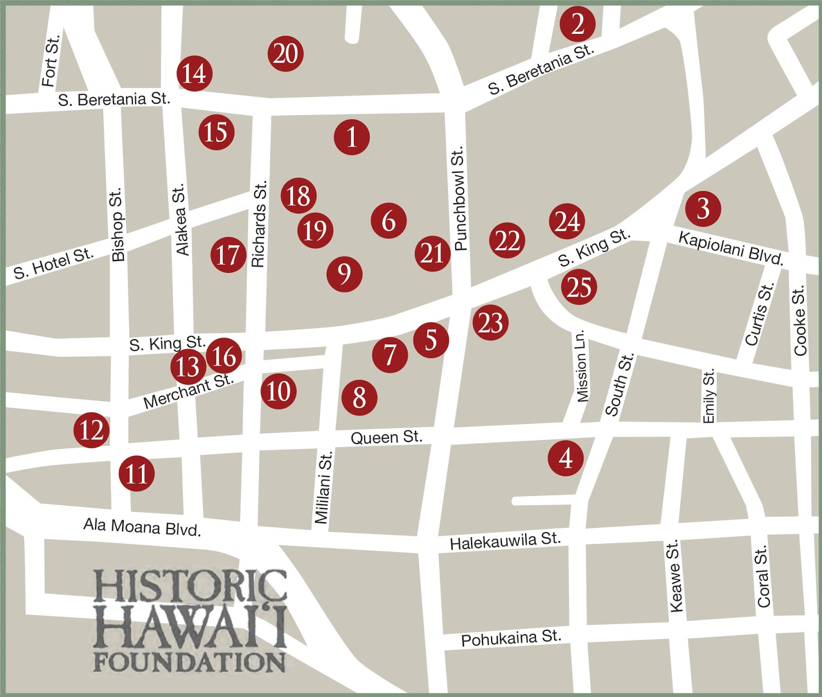
Historic Hawaii Foundation has developed a map and self-guided walking tour documenting twenty-five historic sites along a 3-mile route in historic Downtown Honolulu.
1 - Hawai‘i State Capitol (1969)
Hawaii’s State Capitol building houses the offices of the Governor and Lieutenant Governor, offices of state legislators, and the chambers of the state House and Senate. The Capitol was constructed at the direction of Governor John A. Burns and designed by the firms of Belt, Lemmon & Lo of Honolulu, John Carl Warnecke & Associates and Architects Hawai‘i. The building opened in 1969. Like the Hawaiian Islands, the Capitol is surrounded by water, and the outer columns that rise from the reflecting pools represent Hawaii’s palm trees.
2 - Board of Water Supply Building (1959)
The BWS building was completed in 1959 and was designed by famous architect Hart Wood in a local Hawaiian Style that combined elements of Asian and American influences. The entire building is constructed of reinforced concrete and the exterior was designed by renowned landscape architect Catherine Jones Thompson.
3 - Advertiser Building (1929)
The neo-Renaissance designed building by famed architects Walter Emory and Marshall Webb was home of the iconic Advertiser newspaper for over eighty years until the paper merged with the Star-Bulletin in 2010.
4 - Kaka‘ako Fire Station (1929)
Built in the Spanish Mission style, the historic fi re station is considered to be haunted. It is located across from the graveyard of smallpox victims from the 1850s. Kamehameha III created Honolulu’s fire department, making it the only one in America sponsored by royalty.
5 - Territorial Building (Kekuanao‘a) (1925)
Large fluted Corinthian columns grace the front of this classical revival-style building. A stained-glass dome is positioned above the lobby. Built as a governmental office building it continues to function as such today.
6 - Hawaii State Archives (1906)
Designed by Oliver Traphagen in the Renaissance Revival style, the building also known as Kana‘ina is currently used as the offices for the Friends of ʻIolani Palace. It was originally constructed to house Hawaiian governmental documents from before annexation based on a compromise with the US government.
7 - King Kamehameha Statue (1882)
The 18-foot bronze statue was dedicated in 1883 to represent the famed unifier of the islands, King Kamehameha I. It was sculpted by Thomas Gould in Florence.
8 - Ali‘iolani Hale (1874)
The State Supreme Court and the Judiciary History Center are located here. It is the oldest government building in Hawaiʻi. Originally commissioned as a new royal residence by Kamehameha IV, Kamehameha V decided that it should become an administrative building.
9 - ‘Iolani Palace (1882)
Home to the Hawaiian monarchy before it was overthrown in 1893, ‘Iolani Palace was built in the Italianate style with fluted cast-iron Corinthian columns, decorative iron railings, mansard-style tower roofs, and wide lanai on all sides. After the overthrow, from 1895 to 1968, ‘Iolani Palace served as the capitol of the Republic, Territory and State of Hawaiʻi. Restored to its
original grandeur, the building opened to the public as a historic site in 1978.
10 - US Post Office, Custom House and Court House (1922)
Designed by New York architects York and Sawyer, this classic Mediterranean-style structure features large roof overhangs, shaded arcades, open interior courtyards, spacious porticos and two towers. It is still currently used as the Downtown Post Office.
11-Dillingham Transportation Building (1929)
The Mediterranean/Italian Renaissance style building was designed by architect Lincoln Rogers. The building consists of three wings connected by a covered arcade and spans from Queen Street to Ala Moana Boulevard. It features an Art Deco lobby, painted high ceilings, and a classical cornice.
12 - Alexander & Baldwin Building (1929)
A design collaboration between Charles W. Dickey and Hart Wood. The building is a unique fusion of eastern and western design elements that features a double-pitched hipped tile roof, a fourth floor lanai, water buffalo heads above the first-floor windows, and a matte glazed terra cotta exterior.
13 - Joseph W. Podmore Building (1902)
Located at 202 Merchant Street, it was constructed in the Richardsonian Romanesque style from locally quarried lava rock. It was originally built to be rented out as commercial and office space; it maintains the same purpose today.
14 - St. Andrew’s Cathedral (1867-1958)
It took over ninety years to complete this English Gothic-style headquarters of the Episcopal diocese in Hawaii. After visiting
Queen Victoria in England, Queen Emma raised $30,000 for the Anglican Church in Hawaii and to build St. Andrews Cathedral. Beretania was the Hawaiian interpretation for Britannia.
15 - Hawaii State Art Museum (formerly the Army and Navy YMCA) (1928)
Located on the original site of the Royal Hawaiian Hotel, the site was renovated and reconstructed in the late 1920s to become the Army and Navy YMCA. Designed by Lincoln Rogers, it features an open-sky courtyard; palladian windows; cast-stone detailing; iron-grille work and light fixtures; and arched openings. It is now the home of the Hawaii State Art Museum.
16 - Hawaiian Electric Building (1927)
This four-story building is characteristic of an early 18th century Spanish form that features half-stilted arched windows with
Churriguera -decorated column supports, a corner cupola and a low-rise, polygonal tiled roof. The building was designed by York and Sawyer with construction overseen by Emory and Webb.
17 - YWCA Building (1927)
The first structure in Hawaii designed completely by a woman. Julia Morgan, known for her work on Hearst Castle, designed the building in Spanish, Colonial and Mediterranean styles. It features a two-story loggia flanked by the outer buildings.
18 - ‘Iolani Barracks (1871)
Built between 1870 and 1871, the barracks were home to the Royal Household Guard and are situated within the ‘Iolani Palace grounds. They were designed by Theodore Heuck. The barracks were relocated to the current position during construction of the state capital on the original site.
19- ‘Iolani Bandstand (1883)
Constructed for the coronation of King Kalākaua and Queen Kapi‘olani, the structure was moved and rehabilitated in the late 1900s. Most Friday’s at noon the Royal Hawaiian Band performs weather permitting.
20 - Washington Place (1846)
A Colonial Greek revival-style house was originally built for John Dominis, a clipper ship captain. It is most well known as the inherited residence of his daughter-in-law, Queen Lili‘uokalani. After the overthrow of the Hawaiian monarchy, the Queen lived in Washington Place until her death in 1917. From 1922-2003, the residence housed Hawaii’s governors. It is now a house museum and used for State events.
21 - Hawaii State Library (1913)
The library’s construction was made possible through a gift from industrialist Andrew Carnegie. The Greco-Roman style building was designed by Henry Witchfield and still serves today as the downtown branch of the Hawaii State Public Library.
22 - Honolulu Hale (1929)
Designed by Dickey, Wood and others, this Spanish mission style building features open-to-the-sky courtyards, hand-painted ceiling frescos, 1,500-pound bronze front doors, and 4,500-pound courtyard chandeliers. The main entry faces King Street, behind a zig-zag pattern of planters (for security reasons) and the exterior of the building is complex, with deeply fenestrated windows and balconies of carved stone. The tower is particularly complex and features varied window treatments, open and closed balconies, loggias and cast-concrete grill work.
23 - Kawaiaha’o Church and Cemetery (1842)
This is considered to be the mother Protestant Church in Hawaii. Construction started in 1837 based on Pastor Hiram Bingham’s own design of a “simple New England church”. The structure is comprised of some 14,000 coral blocks, each weighing up to 1,200 pounds. The church continues to conduct services in both English and Hawaiian.
24 - Mission Memorial Building (City Hall Annex) (1915)
Built by the Hawaiian Evangelical Association as a museum and archive to celebrate the 100th anniversary of the Protestant Missionaries in Hawaii. The city took over the building during the 1940s and it has since been converted to the City Hall Annex. It is an example of Georgian architecture.
25 - Mission Houses (1821, 1831, 1841)
These are the oldest standing western structures in Hawaii. The timbers for the first house were cut and fitted in Boston. The initial house introduced New England style architecture to Hawaii. Originally utilized as housing for the missionaries, the buildings exist today as living house museums open to the public.
The image shows the layout of the Historic Downtown Honolulu tour from Historic Hawaiʻi Foundation. In addition, I have added other related images in a folder of like name in the Photos section on my Facebook and Google+ pages.
Click Here to Download App Prototype noting the Sites in Google Earth
(Hover over the number/icon to see the title; click on the number for image and short text (clicking on logo and other links take you to respective websites.))
Follow Peter T Young on Facebook
Follow Peter T Young on Google+
© 2013 Hoʻokuleana LLC
Tuesday, December 11, 2012
Pu‘u O Kaimukī - Telegraph Hill
When King Kamehameha stationed his troops on the beaches of Waikīkī in preparation for the battle to take O‘ahu, he stationed lookouts at Pu‘u O Kaimukī (aka "Kaimukī Hill") to spot enemies arriving by sea.
When Honolulu became a major port, "Kaimukī Hill" was used as a signal station (using semaphore technology,) giving it the name “telegraph hill.” It had broad view over the Pacific and line-of-sight to downtown Honolulu. Back then, they used this vantage point to spot ships coming in, and then conveyed the news to Honolulu.
Optical “telegraphs” or signaling devices have been traced back to ancient times (initially using torches) and were the fastest systems to convey messages over long distances; these “telegraphs” eventually moved toward semaphore towers.
If Internet and its communications channels are at the forefront of the signaling opportunities of the 21st century, the semaphore was the signals intelligence breakthrough at the time of Napoleon (and Washington and Kamehameha.)
Semaphore towers used arms and blades/paddles to convey messages; messages were conveyed/decoded based on the fixed positions of these arms.
During the Napoleonic Wars, the French revolutionized land-based communications with the construction of semaphore towers bearing rotating arms to fashion coded signals. The British quickly followed suit in that new era of signals intelligence.
The semaphore tower/semaphore line design was first thought up by Robert Hooke in 1684 and submitted to the Royal Society. The system was not implemented, though, due to military concerns.
However, this did lead to Claude Chappe developing the first visual telegraph in 1792 - eventually covering much of France via 556 stations. In France, this was the primary source of communication for military and national applications, until it became more widely used in the 1850s.
In Hawaiʻi, Kaimukī Hill had been used as a semaphore signal station ever since Fair Haven (Honolulu Harbor) became prominent in Hawaiian commerce. This semaphore station reported all incoming ships from Koko Head to Barber’s Point.
“Before the telephone was invented, and long before the system was in use in Honolulu, we had the lookout station on Telegraph Hill, which by means of a semaphore arrangement communicated with a station on the building (downtown.) Every merchant was supplied with the code, and whenever a schooner, a steamer, a mail packet, or a man of war, was sighted, the heart of the town knew it immediately.” (Hawaiian Star, February 10, 1899)
“From Telegraph Hill and the slopes toward Waiʻalae may be seen Koko Head, the beautiful expanse of ocean and on clear days the distant islands of Molokai, Lanai, and Maui. On the town side, the residents look over the town, across the cane fields to the Waianae range.” (Evening Bulletin, September 26, 1898)
“Mauka of Diamond Head, for a distance of three or four miles is a high ridge that vernacular geologists call a "hog back." At the most elevated point on this ridge is the debris of Telegraph Hill (Kaimuki). In the olden days vessels coming from the north were signalled to the city from Kaimuki by a semaphore system, clear and effective. The town end of the line was a building on Kaahumanu street, then occupied as a sail loft.” (Hawaiian Gazette, January 13, 1899)
Reportedly, in 1857, a semaphore mechanism on Puʻu O Kaimukī, with large moveable arms, was attached to the top of a sixty-foot pole and used to signal to Honolulu.
The official receiving station from Kaimukī was on Merchant Street, but some have suggested other receiving stations at Kaʻahumanu Street and the foot of Nuʻuanu.
Upon receiving the message, a signal was broadcast to the town noting the names and ports of origin of each ship coming into view. This information was announced in Honolulu by loud proclamation and bell ringing, and preparation made to tow the vessel in by hand or bullock power.
In 1866, the roof of Honolulu Hale on Merchant Street was fitted with a new marine lookout with a taller semaphore, making its signals accessible to a larger segment of the population.
This optical telegraph system was an important tool for residents of Honolulu. The signals were unique and people became familiar with them, so most could decode the signal and know which ships were coming.
Likewise, besides alerting the postmaster to the imminent arrival of the mail, it was helpful to merchants expecting new goods and people awaiting friends and relatives.
Semaphore was then called "marine telegraph", and it seems logical that the early map-makers of Hawaiʻi would name the hill "Telegraph Hill."
"When the telephone system got into working order the lookout station was moved to a position on Diamond Head which gave a view further along the channel, because it was no longer necessary for the station to be in full view of the city.” (Hawaiian Star, February 10, 1899)
Puʻu O Kaimukī had several colloquial names; one was Christmas Tree Park. There’s a bare metal Christmas-Tree-looking pole. It’s not a remnant of the prior semaphore communications, it’s just a Christmas tree, built by the City and County soon after the park’s christening in 1991. Every year since then the big metal tree gets hung with Christmas lights.
It’s also referred to as Reservoir Park, a reminder of the days in the early 1900s when the top of the hill housed a water storage tank for the Honolulu Water Works. Another name is Bunker Hill, from the World War II era when the spot became a handy surveillance bunker for the military.
It’s known today as Puʻu o Kaimukī Park and is just behind (makai) the Kaimukī Fire Station.
On November 13, 1900, the first Marconi wireless telegraph system was set up and messages were sent and received between Oʻahu and Molokaʻi across a twenty-eight mile channel. Military semaphore flag signals are still used, today
The image shows a portion of an 1892 map (DAGS) noting Telegraph Hill. In addition, I have added other related images in a folder of like name in the Photos section on my Facebook and Google+ pages.
http://www.facebook.com/peter.t.young.hawaii
http://plus.google.com/108947657421184863425
© 2012 Hoʻokuleana LLC
Subscribe to:
Posts (Atom)