Showing posts with label Kohala. Show all posts

Sunday, August 3, 2014

Līloa


Nowhere on the island of Hawaiʻi do the palms grow taller than in the valleys of Waipiʻo, and nowhere is the foliage greener, for every month in the year they are refreshed with rains, and almost hourly cooled in the shadows of passing clouds.  (Kalākaua)

Waipi‘o (“curved water”) is one of several coastal valleys on the north part of the Hāmākua side of the Island of Hawaiʻi. A black sand beach, three-quarters of a mile long, fronts the valley, the longest on the Big Island.

For two hundred years or more, Waipiʻo Valley was the Royal Center to many of the rulers on the Island of Hawaiʻi, including Pili lineage rulers - the ancestors of Kamehameha - and continued to play an important role as one of many royal residences until the era of Kamehameha.  (UH DURP)

Royal Centers were where the aliʻi resided; aliʻi often moved between several residences throughout the year. The Royal Centers were selected for their abundance of resources and recreation opportunities, with good surfing and canoe-landing sites being favored.

The Hawaiian court was mobile within the districts or kingdom the aliʻi controlled. A paramount's attendants might consist of as many as 700 to 1000-followers made of kahuna and political advisors (including geologists, architects, seers, messengers, executioner, etc.); servants which included craftsmen, guards, stewards; relatives and numerous hangers-on (friends, lovers, etc.).

Although thinly populated now, Waipiʻo was for many generations in the past a place of great political and social importance, and the tabus of its great temple were the most sacred in all Hawaiʻi. It was the residence of the kings of that island, and was the scene of royal pageants, priestly power and knightly adventure, as well as of many sanguinary battles.  (Kalākaua)

Waipiʻo valley was first occupied as a royal residence by Kahaimoelea, near the middle or close of the thirteenth century, and so continued until after the death of Līloa, about the end of the fifteenth century.  (Kalākaua)

Līloa, the son of Kiha and father of ʻUmi, had become the peaceful sovereign of Hawaiʻi; Kahakuma, the ancestor of some of the most distinguished families of the islands, held gentle and intelligent sway in Kauaʻi; Kawao still ruled in Maui, and Piliwale in Oʻahu.  (Kalākaua)

The reign of Kiha was long and peaceful. He was endowed not only with marked abilities as a ruler, but with unusual physical strength and skill in the use of arms. In addition to these natural advantages and accomplishments, which gave him the respect and fear of his subjects.  (Kalākaua)

The reign of his son Līloa was as peaceful as that of Kiha, his distinguished father (Līloa ruled about the same time that Columbus crossed the Atlantic.) He did not lack ability, either as a civil or military leader.

Līloa’s wife, Pinea, was the younger sister of his mother from a line of chiefs on O‘ahu. They had a son, Hākau. From another wife, Haua, a Maui chiefess, he had a daughter, Kapukini. Both of these marriages established ties between high-ranking families outside the Kingdom of Hawai‘i Island.  (MalamaWaipio)

Līloa was much given to touring through the districts of his kingdom, by which means he acquainted himself with the needs of his people and was able to repress the arbitrary encroachments of the chiefs on the rights of the land-holders under their authority. In this way he gained popularity with the common people.  (Malo)

The story of another of Līloa’s sons, ʻUmi, suggests that while Līloa was on a journey across Hāmākua he met a beautiful woman, Akahiakuleana (Akahi.) They spend the night together and conceive a child. Līloa told Akahi that if she has a son, to name him ʻUmi.

Līloa left his malo (loincloth), his niho-palaoa (whale-tooth necklace) and laʻau palau (club) to be given to the child as proof of ancestry.  ʻUmi later united with Līloa and ultimately ruled the Island of Hawaiʻi (he moved the Royal Center from Waipiʻo to Kailua (Kona.))

At Waipiʻo, Pakaʻalana was the name of Līloa’s heiau. It is not known by whom the Pakaʻalana heiau was built, but it existed before Kiha’s time and so did the sacred pavement leading to the enclosure where the chief’s Royal Center – called Haunokamaahala – stood, though its name has come down to our days as Paepae-a-Liloa.  (Fornander)

“It was a large enclosure, less extensive, however, than that at Honaunau….In the midst of the enclosure, under a wide-spreading pandanus, was a small house, called Ke Hale o Riroa (The House of Līloa), from the circumstance of its containing the bones of a king of that name…..”

“We tried, but could not gain admittance to the pahu tabu, or sacred enclosure. We also endeavored to obtain a sight of the bones of Riroa, but the man who had charge of the house told us we must offer a hog before we could be admitted”.  (Ellis 1826)

Līloa carried a long stone on his shoulder and placed it at the side door of his house. He called this stone “The Sacred Slab of Līloa,” (Ka paepae kapu o Līloa). No one, not even a chief was allowed to stand or walk on this stone. Only two people were allowed to step on “The Sacred Slab of Līloa:” Līloa, the ruler, and Chief Laea-nui-kau-manamana. (Williams)

“The expression ‘Ka Paepae Kapu a Liloa’ as at present used, whether in speaking or writing, refers to the reigning sovereign as to the sacredness of trust imposed upon and reposed to him, and as to the dignity and honour of the position where no intruders are supposed to trespass.  It also refers to the pavement and the way that leads up to royalty, and as to the footstool of sovereignty and power.”  (Bacchilega)

Although the glory of the old capital departed with its abandonment as the royal residence, the tabus of its great temple of Pakaʻalana continued to command supreme respect until as late as 1791, when the heiau was destroyed, with all its sacred symbols and royal associations, by the confederated forces of Maui and Kauai in their war with Kamehameha I.  (Kalakaua)

“There are many references to this famous place (Pakaʻalana) … the tabus of its (Waipi‘o) great heiau were the most sacred on Hawaiʻi, and remained so until the destruction of the heiau and the spoliation of all the royal associations in the valley of Waipi‘o by Kāʻeokūlani, king of Kauaʻi, and confederate of Kahekili, king of Maui, in the war upon Kamehameha I, in 1791 ...” (Stokes)

King Kalākaua moved the slab (Ka Paepae Kapu a Liloa) to Honolulu.  It sits silently and often unnoticed, outside the Archives Building on the grounds of ʻIolani Palace.  The stone holds the historical and cultural significance of a Royal Center in Waipiʻo associated with Līloa; he was “sacred in the eyes of his people for his many good qualities.”  (Bacchilega)

An ancient chant, later put to music, notes: Aia i Waipiʻo Pākaʻalana e; Paepae kapu ʻia o Līloa e (There at Waipiʻo is Pākaʻalana; And the sacred platform of Līloa.)

The March 10, 1899 issue of the Hawaiian Gazette noted that Līloa (1500s,) Lonoikamakahiki (late-1500s) and Alapaʻi (1700s) are among the reburied at Mauna ʻAla.

The image shows the Hawaiʻi Archives Building; to the right is Paepae Kapu O Līloa (interestingly situated in front of a plaque to Captain James Cook.) Nearby are Nā Kālai Pōhaku a ʻUmi.  In addition, I have added other images in a folder of like name in the Photos section on my Facebook and Google+ pages.

Follow Peter T Young on Facebook 

Follow Peter T Young on Google+ 

Follow Peter T Young on LinkedIn   

© 2014 Hoʻokuleana LLC

Saturday, August 2, 2014

James Wight


James Wight was born in India in 1814 of Scotch-Irish parentage; he received liberal education at the University of Edinburgh, where he graduated in 1836.

At 22 years of age, he went to Australian with the intention of practicing his profession as physician, but his interest was for business pursuits.  After thirteen years practicing medicine, there he abandoned the profession and migrated to Hawaiʻi.  (Hawaiian Gazette, September 5, 1905)

Wight, with the initial intent to go to the gold fields of California, came to Hawaiʻi in 1850 with his wife (Jane Tompkins Wight - formerly of Cape Colony, South Africa, now called Cape of Good Hope.)

On August 2, 1850, they went from Honolulu to Kawaihae and from there to Mahukona in an open boat.

While attempting to land ashore at Mahukona on the Big Island of Hawaiʻi, the small boat was ship wrecked during a storm.  Their 13-month old daughter Ada Wight drowned during the tragedy.

Once ashore, Dr. Wight was made aware of white parishioners living close by. He made the decision to venture out and get help for his ailing family.  (Restarick)

They were given a grass house and there during the night, Jane Wight gave birth to a child while the dead one lay in the room.  (The Wights had 13 children, six of whom died before they were grown.)

The Wights were persuaded to stay in Hawaiʻi; he became an influential community leader, serving as postmaster, circuit judge (1852-1863,) representative to the territorial government (1886) and a member of the house of noble (1886-87.)  In the House, he was noted for his independent stand and those were trying times.

He enjoyed remarkably good health during his long life and Dr. Wight’s home was noted for its hospitality. His word was his bond and during his long residence he was seldom involved in litigation. Of the thousands who have been in his employ, all speak of him as a generous though firm employer.

Although he had no inclination to practice medicine, he was always ready to assist any sufferer needing the services of a physician.    (Hawaiian Gazette, September 5, 1905)

He had initially established a store with a pharmacy and carried on business until 1884, when he sold it to SG Wilder.  Wight then turned his business interest to land investments and Hawaiʻi’s emerging sugar and cattle industries.

He became interested in sugar when the Kohala Plantation was started and paid quite an interest in that concern. He established the Hālawa Plantation and conducted it for a number of years.    (Hawaiian Gazette, September 5, 1905)

Wight bought Puakea and built the first animal mill on the Island to process sugar and began raising cattle.  (Wight’s daughter Clara and her husband Howard Rattenbury Bryant continued the cultivation of sugar cane at Puakea until 1930 when the last crop was milled and the operation closed.)  Parker Ranch later leased the Puakea lands from the Estate and finally purchased the ranch in 1944.

Wight was reportedly one of the first to import orchids from England and ironwood trees from Australia.  Mrs. Wight owned the first carriage seen in Kohala. It had a single seat with a perch forward for the driver.

In approximately 1860, the family purchased a large parcel of land that looked out over the ocean on which to build their homestead.

They built a home, Greenbank, on 22-acres in Kohala; it was once a showcase home and social center of the Kohala district for many years.  (The property is reportedly haunted; a stone shark god idol at the property was later given to Bishop Museum.)

Several buildings were added to the estate, including additional residence, caretaker quarters and a carriage house for his buggy. Later years would include a greenhouse adjacent to the main house where some of the first botanical species in the state were grown.

Dr. James Wight passed away on the morning of September 2, 1905 at Kohala; he was the oldest and one of the most respected of the foreign settlers in that district.

He had been closely identified with the progress of the islands for more than fifty-five years.  (Hawaiian Gazette, September 5, 1905)  (Lots of images and information here from greenbankhawaii.)

The image shows the Greenbank home (it no longer exists.)   In addition, I have added other related images in a folder of like name in the Photos section on my Facebook and Google+ pages.

Follow Peter T Young on Facebook  

Follow Peter T Young on Google+ 

Follow Peter T Young on LinkedIn   

© 2014 Hoʻokuleana LLC

Friday, June 6, 2014

Hawaiʻi Preparatory Academy


Marines and Sailors trained for what has been referred to as the toughest marine offensive of WWII. 1,300 miles northeast of Guadalcanal, the Japanese had constructed a centralized stronghold force in a 20-island group called Tarawa in the Gilbert Islands.

The Marines would reconstitute at Camp Tarawa at Waimea, on the Island of Hawaiʻi.  Originally an Army camp named Camp Waimea, when the population in town was about 400, it became the largest Marine training facility in the Pacific following the battle of Tarawa.

Huge tent cities were built on Parker Ranch land; the public school and the hotel across the road from it were turned into a 400-bed hospital. At first the school children attended classes in garages and on lanais, but by fall of 1944, Waimea School was housed in new buildings built by Seabees on the property behind St. James’ church.

Over 50,000-servicemen trained there between 1942 and 1945; it closed in November 1945. The new roads, reservoirs and buildings were left to the town. The public school children returned to Waimea School, and the buildings behind St. James’ stood empty … but not for long.

At the end of World War II, the Right Reverend Harry S Kennedy arrived. He was a builder of congregations and of schools, and when he saw the empty buildings at St. James’, he immediately saw possibilities.

March 12, 1949, Bishop Kennedy and a group of local businessmen turned the buildings into a church-sponsored boarding school for boys, Hawaiʻi Episcopal Academy.  The Episcopal priest was both headmaster of the school and vicar of St. James’ Mission.

The early school struggled with facilities and financing. A turning point came in 1954, when James Monroe Taylor left Choate School in Connecticut to become HPA headmaster.

Three years later, substantial financial pledges came in and the church surrendered its direction to a new governing board. The school was then independently incorporated and the name changed to Hawai‘i Preparatory Academy.

In January 1958, the board of governors purchased 55-acres of land in the foothills mauka of the Kawaihae-Kohala junction and announced plans to build a campus there. Within a year, two dorms opened on the new campus and another was cut and moved from the town campus.

Old Air Force buses driven by faculty members made daily runs between the new campus, where boarders ate and slept, and the old campus, where classes were held. The last class to graduate on the town campus was the Class of 1959.

Honolulu architect Vladimir N Ossipoff was retained to design the campus buildings - five classroom buildings, two residence halls, a chapel, a library, an administration building and a dining commons.

In 1976, HPA acquired the buildings of the former Waimea Village Inn in town. Growing out of the “Little School” founded in 1958 by Mrs T to accommodate children of HPA faculty in the lower grades, the Village Campus today houses HPA’s Lower and Middle Schools, encompassing kindergarten through eighth grade.

In the 1980s, 30-acres of Parker Ranch land were added to the Upper Campus. Besides the Village Campus, the school added the Institute for English Studies and a campus in Kailua-Kona for grades K-5. (The Kona campus became the independent Hualālai Academy, but it closed effective May 30, 2014.)

Building projects expanding the HPA facilities included Atherton House, the headmaster’s residence, Gates Performing Arts Center, Dowsett Pool, Gerry Clark Art Center, Davenport Music Center, Kō Kākou Student Union, faculty housing and the Energy Lab.

Starting with five boarding students in a World War II building, today, there are 350 students at the Upper School – half boarders and half day students; grades K-8 at the Village Campus comprise 250 students.  (Still a boarding school, the boarding program admits students in grades six through 12.)

HPA is fully accredited by the Western Association of Schools and Colleges and is a member of 12 educational organizations including the Council for the Advancement and Support of Education, College Entrance Examination Board, Council for Spiritual and Ethical Education, Cum Laude Society, National Association of College Admission Counselors, Hawaii Association of Independent Schools, and National Association of Independent Schools.  (Information here from HPA and St James.)

I was one of the fortunate boys-turned-to-young-men under the leadership and guidance of headmaster Jim Taylor.

The image shows a 1948 image of the old St James's church (with what was the beginning of HPA in the rear.  (St James)  In addition, I have added other images in a folder of like name in the Photos section on my Facebook and Google+ pages.

Follow Peter T Young on Facebook  

Follow Peter T Young on Google+    

Follow Peter T Young on LinkedIn   

© 2014 Hoʻokuleana LLC

Wednesday, April 30, 2014

Suiter Field


In 1779, Captain Cook explored the North Kohala area and noted:
“The country, as far as the eye could reach, seemed fruitful and well inhabited … (3 to 4-miles inland, plantations of taro and potatoes and wauke are) neatly set out in rows. The walls that separate them are made of the loose burnt stone, which are got in clearing the ground; and being entirely concealed by sugar-canes planted close on each side, make the most beautiful fences that can be conceived …”  (Cook Journal)

Fast forward 150-years to a property in this area within two traditional Hawaiian ahupuaʻa (land divisions.) The eastern half of the property is located within the ahupuaʻa of Kealahewa (wrong way) and the western half is located within the ahupuaʻa of Opihipau (opihi (limpets) all gone.)  The property was used by the Hawi Mill and Plantation Company in its sugar operations.

Later, on June 25, 1927, an Executive Order set aside nearly 38-acres of the property for an airplane landing field for the US Air Service to be under the management and control of the War Department.

The airfield is about three miles northwest of the town of Hawi on the northern tip of the coast of the Big Island of Hawaiʻi.  In 1933, the Army named it Suiter Field, in honor of 1st Lieutenant Wilbur C Suiter who was killed in action serving in 135th Aero Squadron.

Suiter was posthumously issued the Distinguished Service Cross and Silver Star Citation for extraordinary heroism in action.  He and his observer (Guy E Morse) fearlessly volunteered for the perilous mission of locating the enemy's advance unit in the rear of the Hindenburg line.

Disregarding the hail of machine gun fire and bursting anti-aircraft shell, they invaded the enemy territory at a low altitude and accomplished his mission, securing information of the greatest importance.

They at once returned to the lines and undertook another reconnaissance mission, from which they failed to return.  (Morse Field, the military’s air field that was once at South Point was named after 2nd Lieutenant Guy E Morse.)

Suiter Field was first licensed in 1928.  It was also alternatively referred to as Upolu Point Military Reservation, Upolu Landing Field, Upolu Airplane Landing Field and Upolu Airport.

In the early days of aviation in Hawaiʻi, the US Signal Corps maintained a communication station at Suiter Field.  Inter-Island Airways (later known as Hawaiian Air,) which began passenger service in 1929, used the field as an emergency stop on its route to Hilo, as well as to provide air service to the district of Kohala.

On June 26, 1929, Governor’s Executive Order No. 363 added 57-acres to Upolu Airplane Landing Field to be under the control and management of the War Department.  Shortly thereafter, December 16, 1929, the Territorial Aeronautics Commission sought to have the property returned to the Territory for the Upolu aeroplane landing field.

In January 1930, the War Department granted the Territory concurrent use of the Army landing field for official and commercial aviation use.  Within 7-months later, about 97-percent of the land was restored to the Territory.  A couple of months later, about 95 acres were dedicated to establish the Upolu Airport under control of the Territory.

Upolu field was grass on a sandy soil and partially graded.  The Army maintained a barracks and radio station at the field on Federal property. The Upolu Point Airport consisted of one large runway in the shape of an hour glass 3,500 feet long.

Before the bombing of Pearl Harbor on December 7, 1941, a contract had been let and work was ready to start on the new airport – the war stopped that.  During World War II, the Navy occupied Upolu Airport establishing a weather and communication station there.  The facility was used as an auxiliary field to the Naval Air Station, Hilo, for field-carrier-landing practice and other training of carrier pilots.

The Upolu Point Military Reservation included facilities for naval purposes and for the operation and maintenance of military airplanes and airships. These facilities included a 150-foot-wide by 4,000-foot long surfaced runway, an aircraft parking area, a catapult deck, administration buildings, personnel quarters and a bunch of support buildings.

A simulated deck of an aircraft carrier was installed and air-group pilots completed their training by qualifying in day and night deck landings before going aboard the carriers for combat duty.  From July 1944 to May 1947 the facility was used exclusively for naval and other military purposes.

Upolu Airport was returned to the Territory after the war, and air service was provided by scheduled and non-scheduled operators.  Buildings formerly occupied by the Navy were rehabilitated for use as a terminal and for other purposes.

It was used for a time by Inter-Island Airways, Ltd. for small Sikorsky amphibians, but could not be used for large aircraft.  A 1946 Master Plan for Upolu included a 4,000 foot by 150 foot runway.  By 1948, the paved runway was 4,000 feet in length and Upolu was the only airport in that part of the island which met the requirements for scheduled airline operation.

Hawaiian Airlines was the principal user of the airport and made one stop a day en route from Honolulu to Hilo, and one stop en route from Hilo to Honolulu.

A new Master Plan was completed in March 1999. The airfield included a single runway (7-25), taxiway and an aircraft parking apron.  Runway 7-25 was 3,800 feet long and 75 feet wide and aligned in an east-northeast to west-southwest direction.

There has been no scheduled commuter service at the airport since 1986.  There are no cargo facilities at Upolu Airport, no control tower, and no aircraft rescue and firefighting facilities (nor fuel storage facility.)  There are only infrequent aircraft at Upolu Airport; airport management is under the Kona International Airport manager.  (Lots of info here from hawaii-gov.)

The image shows Suiter Field at Upolu Point in 1929 (Hawaii-gov.).  In addition, I have added related images in a folder of like name in the Photos section on my Facebook and Google+ pages.

Follow Peter T Young on Facebook  

Follow Peter T Young on Google+    

Follow Peter T Young on LinkedIn   

© 2014 Hoʻokuleana LLC

Wednesday, December 4, 2013

Poʻo Kanaka


Traditional translations of poʻo kanaka suggest it means “human head;” however, in this case, it has a regional translation and is used to describe a flower, the pansy (folks thought the flower looked like a man’s head.)

It was also the name given to a man’s home.

He is said to have been the first to introduce the pansy flower in Hawaiʻi and he planted pansies around his house.  (Kimura)

Puapoʻo-kanaka ("The flower-that-looks-like-a-man") eventually became the favorite of Waimea cowboys, who wore entire leis of pansies strung round their flopping vaquero hats.  (Korn)

The house stood within a level clearing at a spot called Puʻukapu, along the trail leading to the more upland forested area up Mauna Kea known as Manaiole, what we call Mānā, today.

The house, built in the 1830s, was made of rubble-and-mortar construction.  Rocks were formed into walls and plastered over with putty lime mortar (the lime obtained from ground coral.)  Rubble ruins remain of the house site, today.

The home was described as an Irish stone cottage.

It’s not clear what the man’s real name was – some suggest it was initially William Wallace.  An Irishman, he came to Hawaiʻi aboard a whaling ship that landed at Kawaihae (about 1834.)  He left the ship and went up the hill to Waimea, where he settled – there, he took the name Jack Purdy.  (Kimura)

Some suggest Purdy, along with fellow Waimea resident John Palmer Parker, can be considered the first cowboys in Hawaiʻi.  They started out as bullock hunters, selling their salt beef, hides and tallow.

In the early-1830s, trade in sandalwood slowed down as island forests became depleted.  At about the same time, whaling ships hunting in the north Pacific began wintering in Hawaiian waters.

Ships provisioning in Hawaiʻi ports provided a market for salt beef, in addition to hides and tallow.  With the economic push of providing provisions to the whaling fleets, ranching became a commercial enterprise that grew in the islands.

Parker took a more business-like approach and took advantage of the opportunities of the day and established the Parker Ranch in the fledgling livestock industry.  Purdy was a rowdy, living the rugged life, typical of his peers in the early American West.  (Bergin)

A real or tall tale of his exploits (written in 1857) tells how Jack Purdy, mighty bullock hunter and expert guide, together with his employer and hunting companion, Mr. Julius Brenchley, succeeded without firearms - in fact not even equipped with their usual lassos - in capturing a ferocious wild bull and in killing the beast when he failed to extricate himself from a mudhole; and then celebrated their victory with a deserved steak dinner fresh off the carcass.  (Korn)

In 1832, Purdy married into Hawaiian royal lineage when he took Keawe-maʻu-hili (daughter to Kewae-a-heulu and Kaʻakau) as his bride.  Several of his children from that and his second marriage were respected cowboys.   (Bergin)

His grandson, Ikua Purdy, made headlines and national fame, when he won the World’s Steer Roping Championship in Cheyenne, Wyoming - roping, throwing and tying the steer in 56 seconds (on a borrowed horse.)  Ikua had worked at Parker Ranch, he later moved to Maui to ʻUlupalakua Ranch (he died there in 1945.)

Jack Purdy (William Wallace Jack Harry Hale Purdy) died on June 22, 1886, at the age of 86; he is buried near his home, Poʻo Kanaka.

The image shows a Poʻo Kanaka, the ruins of the former stone cottage of Jack Purdy (Parker Ranch.)    In addition, I have included other images in a folder of like name in the Photos section on my Facebook and Google+ pages.

Follow Peter T Young on Facebook  

Follow Peter T Young on Google+    

© 2013 Hoʻokuleana LLC

Monday, December 2, 2013

It was a dark and stormy night …


“It was said that on a certain night of heavy down pouring rain - the lightning struck its wrathful flashes into the sky - the thunder pounded with all its might - the stormy wind veered every which way - the red water churned in the streams.”  (Poepoe, Ahlo)

The child born that night was of royal blood, and was destined to become not only the king of Hawaiʻi, but the conqueror and sovereign of the group.

They say the child was poʻolua, “that is, a child of two fathers, (it) was considered a great honor by chiefs of that period.” (Luomala)  Some say that his mother, Kekuʻiapoiwa (married to Keōua,) had a liaison with Kahekili (ruler of Maui.)

Though Kahekili was thought to possibly be his biological father, he was raised by his parents (and was considered the son of Kekuʻiapoiwa and Keōua.)

The exact year of his birth is not known; different historians/writers place the year of his birth from about 1736 to 1759.

He was said to be born at Kokoiki (''little blood,'' referring to the first signs of childbirth – Kokoiki is one of the star names listed in the Kumulipo chant.)

Another notes, "(A) bright and beautiful star, appeared at Kokoiki on the night before the child was born and is hence called Kokoiki.”  (Kūʻokoʻa Home Rula, Ahlo)  (Scientific study places Halley’s Comet in the same relative position in the Hawaiian sky on December 1, 1758.  (Ahlo))

Keʻāulumoku predicted that he “would triumph over his enemies, and in the end be hailed as the greatest of Hawaiian conquerors.”  (Kalākaua)

Word went out to find and kill the baby, but the Kohala community conspired to save him.

"A numerous guard had been set to wait the time of birth. The chiefs kept awake with the guards (for a time,) but due to the rain and the cold, the chiefs fell asleep, and near daybreak Kekuʻiapoiwa went into the house and, turning her face to the side of the house at the gable end, braced her feet against the wall.”

"A certain stranger (Naeʻole) was outside the house listening, and when he heard the sound of the last bearing-down pain (kuakoko), he lifted the thatch at the side of the house, and made a hole above.”

“As soon as the child was born, had slipped down upon the tapa spread out to receive it, and Kekuʻiapoiwa had stood up and let the afterbirth (ewe) come away, he covered the child in the tapa and carried it away.”  (Kamakau)

The young child, Kamehameha, was carried on a perilous journey through Kohala and Pololū Valley to Awini.  (KamehamehaDayCelebration)

Hawi, meaning ''unable to breathe,'' was where the child, being spirited away by a servant, required resuscitation and nursing. Kapaʻau, meaning ''wet blanket,'' was where heavy rain soaked the infant's kapa (blanket.)  Halaʻula (scattered blood) was the town where soldiers were killed in anger.  (Sproat – (Fujii, NY Times))  Some believe Kamehameha also spent much of his teen years in Pololū (long spear.)

“Kamehameha (Kalani Pai‘ea Wohi o Kaleikini Keali‘ikui Kamehameha o ‘Iolani i Kaiwikapu Kaui Ka Liholiho Kūnuiākea) was a man of tremendous physical and intellectual strength. In any land and in any age he would have been a leader.”  (Kalākaua, ROOK)

While still in his youth, Kamehameha proved his right to rule over all the islands by lifting the Naha Stone at Pinao Heiau in Pi‘ihonua, Hilo (c. 1773.) (ROOK)

By the time of Cook's arrival (1778,) Kamehameha had become a superb warrior who already carried the scars of a number of political and physical encounters. The young warrior Kamehameha was described as a tall, strong and physically fearless man who "moved in an aura of violence." (NPS)

The impress of his mind remains with his crude and vigorous laws, and wherever he stepped is seen an imperishable track. He was so strong of limb that ordinary men were but children in his grasp, and in council the wisest yielded to his judgment. He seems to have been born a man and to have had no boyhood.  (Kalākaua)

He was always sedate and thoughtful, and from his earliest years cared for no sport or pastime that was not manly. He had a harsh and rugged face, less given to smiles than frowns, but strongly marked with lines indicative of self-reliance and changeless purpose.  (Kalākaua)

He was barbarous, unforgiving and merciless to his enemies, but just, sagacious and considerate in dealing with his subjects. He was more feared and admired than loved and respected; but his strength of arm and force of character well fitted him for the supreme chieftaincy of the group, and he accomplished what no one else could have done in his day.  (Kalākaua)

In 1790 (at the same time that George Washington was serving as the US’s first president,) the island of Hawaiʻi was under multiple rule; Kamehameha (ruler of Kohala, Kona and Hāmākua regions) successfully invaded Maui, Lānaʻi and Molokaʻi.

He sent an emissary to the famous kahuna (priest, soothsayer,) Kapoukahi, to determine how he could conquer all of the island of Hawaiʻi.  According to Thrum, Kapoukahi instructed Kamehameha "to build a large heiau for his god at Puʻukoholā, adjoining the old heiau of Mailekini."

It is estimated that the human chain from Pololū Valley to Puʻukohola had somewhere between 10,000-20,000 men carrying stones from Pololū Valley to Kawaihae. (NPS)

After completing the heiau in 1791, Kamehameha invited Keōua to come to Kawaihae to make peace.  However, as Keōua was about to step ashore, he was attacked and killed by one of Kamehameha's chiefs.

With Keōua dead, and his supporters captured or slain, Kamehameha became King of Hawaiʻi island, an event that according to prophesy eventually led to the conquest and consolidation of the islands under the rule of Kamehameha I.

It was the koa (warriors) of Hilo who supported Kamehameha in his early quest to unite Moku O Keawe. After gaining control of Moku O Keawe, Kamehameha celebrated the Makahiki in Hilo in 1794.  (ROOK)

The village and area of Hilo was named by Kamehameha after a special braid that was used to secure his canoe. Kamehameha and Keōpūolani’s son, Liholiho (Kamehameha II) was born in Hilo (1797.)  (ROOK)

Kamehameha’s great war fleet, Peleleu, that was instrumental in Kamehameha’s conquest, was built and based at Hilo (1796-1801). After uniting all of the islands under his rule in 1810, Hilo became Kamehameha’s first seat of government.  (ROOK)

It was in Hilo that Kamehameha established his greatest law, the Kānāwai Māmalahoe (Law of the Splintered Paddle).  (ROOK)  Kamehameha’s Law of the Splintered Paddle of 1797 is enshrined in the State constitution, Article 9, Section 10:  “Let every elderly person, woman and child lie by the roadside in safety”.

It has become a model for modern human rights law regarding the treatment of civilians and other non-combatants.  Kānāwai Māmalahoe appears as a symbol of crossed paddles in the center of the badge of the Honolulu Police Department.

The image shows Kamehameha as a young warrior (HerbKane.)  In addition, I have added other related images in a folder of like name in the Photos section on my Facebook and Google+ pages.

Follow Peter T Young on Facebook  

Follow Peter T Young on Google+    

© 2013 Hoʻokuleana LLC

Monday, November 25, 2013

Kohala Ditch


Central to Hawaiʻi’s use of water has been agriculture, sugar in particular.

Initially brought to the islands by early Polynesians, the first successful commercial sugar plantation started in 1835.  And, with it, Hawai`i’s environmental, social and economic fabric changed.  Hawaiʻi's economy turned toward sugar in the decades between 1860 and 1880; these twenty years were pivotal in building the plantation system.

What encouraged the development of plantation centers?  For one, the American settlement of California opened lucrative avenues of trade in the Pacific.  In addition, the Civil War virtually shut down Louisiana sugar production during the 1860s, enabling Hawai'i to compete in a California market that paid elevated prices for sugar.

The Pacific whaling trade collapsed after 1860, pushing Honolulu merchants into the sugar trade.  About the same time, the closing of the Hawaiian mission left the previously supported missionaries in search of new means of income.

The 1876 Treaty of Reciprocity between the United States and the Kingdom of Hawaiʻi eliminated the major trade barrier to Hawai`i’s closest and major market.  Through the treaty, the US received a station at Pearl Harbor and Hawaiʻi’s sugar planters received duty-free entry into US markets for their sugar.

For nearly a century, agriculture was the Island's leading economic activity. It provided Hawai`i's major sources of employment, tax revenues, and new capital through exports of raw sugar and other farm products.

Sugarcane requires a lot of water to grow. Pioneer sugar planters solved water shortages by diverting stream water and building irrigation systems that included aqueducts (the first in 1856), artesian wells (the first in 1879), and tunnels and mountain wells (the first in 1898).  These irrigation systems enabled the planters to expand their sugar production.

These irrigation systems were modeled largely after the elaborate and extensive diversion and ditches developed by the ancient Hawaiians.  Unlike the traditional Hawaiian system, which never diverted more than 50% of stream flow, the sugar plantations diverted large quantities of water from perennial streams and moved water from one ahupuaʻa to another.

Boston missionary Reverend Elias Bond sailed with the Ninth Company of Protestant Missionaries, arriving in the Islands in 1841. He was then assigned to Kohala.

As a means to provide employment to the people in the region and support his church and schools, in 1862, Reverend Bond founded Kohala Sugar Company, known as "The Missionary Plantation;” it produced its first sugar crop in 1865.  Bond gave all his dividends and profits beyond his living expenses to the Board of Missions.

Bond included the following in a letter: "So this was the 'Missionary Plantation', and the prophecies were many and loud that it would not live five years". But in the goodness of God we came through."  (Schweitzer)

From the mid-1800s, the sugar industry developed and commercial centers sprung up around the processing mills, especially in Kapaʻau and Hawi.  The construction of the railroad and the Kohala Ditch acted to encourage the further development of these more centrally-located communities.

Seven sugar mills operated in Kohala: Kohala, Union, Niuliʻi, Hawi, Halawa, Hōʻea and Star.  With the exception of Star, which existed for only a brief period of time, each was the nucleus of a community of plantation managers, supervisors, and laborers.  (In 1937, all of the mills were consolidated into Kohala Sugar Company.)

To water the crop, John Hind first conceived of an irrigation system tapping into the abundant, wild and inaccessible rivers that ribbon the Kohala Mountains.  In 1904, JS Low acquired a license from the Territory of Hawaiʻi to "enter upon, confine, conserve, collect, impound and divert all the running natural surface waters on the Kohala-Hāmākua Watershed;" he assigned the license to the Kohala Ditch Company.

Notable engineers and other professionals became involved in the construction of irrigation ditches that were the forerunners of large irrigation projects in the Western US.  Among the engineers was Michael Maurice O'Shaugnessy; he was both an investor in the Kohala Ditch Company and the Chief Engineer for the aqueduct.  (ASCE)

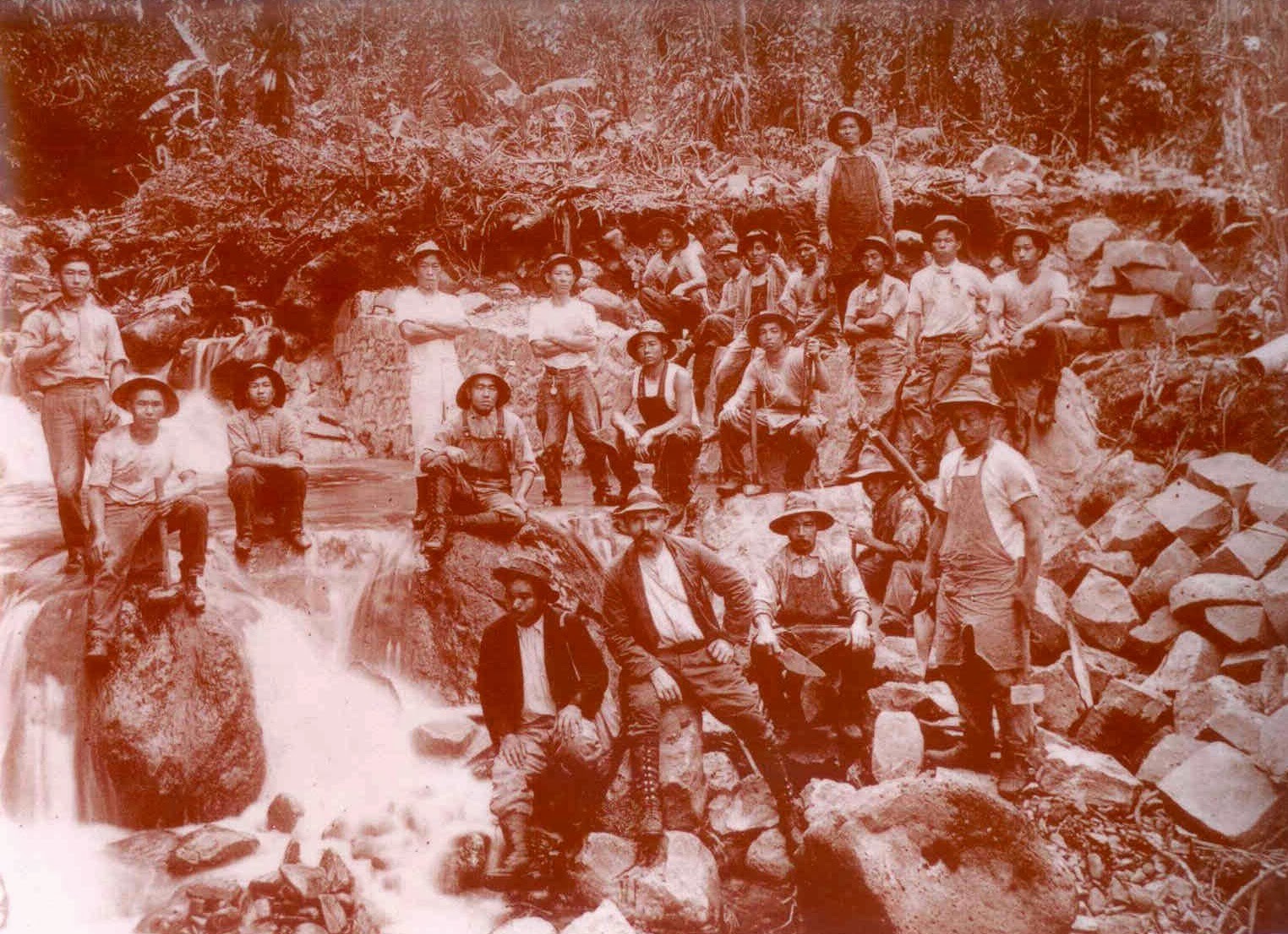
The Kohala Ditch, built by the Kohala Sugar Company, diverted water from the Honokāne Nui Stream to Hikapoloa, west of Hawi.  600-Japanese laborers worked on its construction; in the process, 17 lost their lives.

The laborers were housed under corrugated iron roofs. The raised floors “nearly always two-feet above the ground and higher if practicable” provided “a place for drying the men’s clothes in wet weather.” Additionally, “a hospital and medical department was also provided for the men, who were assessed 50-cents a month apiece for this object.”  (ASCE)

The Honokāne section of Kohala Ditch was opened on June 11, 1906; waters of Honokāne began flowing to the Kohala, Niuliʻi, Halawa, Hawi and Union mills.  The Awini section was finished in 1907; it started from the Waikoloa stream and traveled over 8-miles, mostly in tunnel, to the Awini weir where the water dropped 900-feet in a manmade waterfall into the Honokāne section.

The ditch carried the water for 23-miles northwest, mostly as tunnel, toward Hawi.  The capacity was originally 70-mgd, later reduced to 50-mgd, when the original flumes were replaced with smaller ones.

The ditch drops about 80-feet in elevation from 1,045-feet at the bottom of the intake at the first large stream (Honokāne) to 956-feet at the terminus in the plantation fields.

Prosperity came to Kohala. At the peak of its production, the Sugar Company had 600-employees; 13,000-acres of land produced 45,000-tons of raw sugar a year.

As with other sugar operations, it didn’t last.  1975 saw the last harvest at Kohala Sugar Company.  The district’s economy struggled.  Almost one-third of the workforce now commutes to South Kohala to work in the hotels and resorts located there.  However, the Ditch remained open for other agricultural needs.

Vulnerability and the risks associated with reliance on the Kohala Ditch were made evident on October 15, 2006, when two earthquakes struck off Kiholo and caused extensive damage to the Kohala Ditch.  In that instant, rockslides and other damage to the ditch stopped the water from flowing through the Ditch.

Two years later, on November 25, 2008, after extensive community involvement and public/private funding ($2-million in federal money, $500,000 from the state, $500,000 from Hawai`i County, $342,000 from Kamehameha Schools and $100,000 from AT&T), water was released back into the Kohala Ditch after repairs to the damage caused by the 2006 quakes.

Agricultural and hydroelectric users continue to benefit from the Ditch; in addition, entrepreneurs saw an opportunity for recreational/visitor industry uses of the ditch with kayak and raft rides through the flumes and tunnels of the Kohala Ditch.

The image shows workers in the construction of the Kohala Ditch.  In addition, I have added other related images in a folder of like name in the Photos section on my Facebook and Google+ pages.

Follow Peter T Young on Facebook  

Follow Peter T Young on Google+  

© 2013 Hoʻokuleana LLC

Wednesday, November 13, 2013

Kawaihae


Kamehameha had granted Kawaihae Komohana ahupua‘a (present Kawaihae 1) to Kalanimōku, his “prime minister;” Kawaihae Hikina (present Kawaihae 2) was one of several ahupuaʻa on Hawai‘i and other islands allocated to John Young by Kamehameha.

Kamehameha had a house here.  Following his death and the succession of Liholiho to rule as Kamehameha II, Kawaihae served as the initial Royal Center for Liholiho, who sought consolidation of his forces and consecration of his leadership role, there.  (Kelly)

Then, as now, the area was relatively barren and people typically lived near the shore, not up the hill.   As noted in 1832, by missionary Lorenzo Lyons in his journal, “about as desolate a place as I have ever seen, nothing but barrenness, with here and there a native hut”.

The area is also generally referenced as Pelekane, which means ‘British,’ possibly named after the Young and Isaac Davis families that lived there (when Davis died in 1810, his friend and co-advisor to Kamehameha, John Young, looked after Davis’ children.)

These were not the only high-ranking people associated with Kawaihae during the first decades of the 19th century. Kamāmalu, daughter of Kamehameha and Kaheiheimālie was born at Pelekane (ca 1802.)

She would later become the wife of her half-brother Liholiho (Kamehameha II,) the son of Kamehameha and the high chiefess Keōpūolani (Kamāmalu died of measles in London with Liholiho in 1825.)  Some suggest Queen Emma (granddaughter of John Young) was also born here.

Over time, Kawaihae and Waimea (up the hill) developed a synergistic relationship.  The area was a canoe landing area, whether for commerce or combat.  (This is where Maui’s chief Kamalālāwalu landed in his assault against Lonoikamakahiki’s Hawaiʻi forces (Lono won.)  But Kawaihae’s presence was really focused on commerce as a landing site.

Archibald Menzies, reporting on Vancouver’s third layover at Kawaihae Bay in March 1793 after leaving Kealakekua Bay, recorded that Young and Davis had accompanied “us thither (i.e. to Kawaihae) on purpose to make presents of hogs and vegetables...from their plantations, which lay near this part of the island...”  (Menzies, Cultural Surveys)

Young built a storehouse in his family compound.  During the sandalwood trade, Young supervised royal warehouses that were the central depository for the wood brought in from the surrounding district.

William Ellis, in 1831 wrote, “Before daylight on the 22d, we were roused by vast multitudes of people passing through the district from Waimea with sandalwood, which had been cut in the adjacent mountains for Karaimoku (Kalanimōku,) by the people of Waimea, and which the people of Kohala, as far as the north point, had been ordered to bring down to his storehouse on the beach, for the purpose of its being shipped to Oahu.  There were between two and three thousand men, carrying each from one to six pieces of sandalwood, according to their size and weight.”

Another early foreign visitor to Kawaihae was Frenchman, Louis Claude Desaulses de Freycinet, in 1819; he met Liholiho here.  Following closely in the wake of Freycinet's visit of 1819 were the American missionaries, who stopped first at Kawaihae on April 1, 1820 (before heading down to Kailua-Kona.) They were met by Kalanimōku and his wives and two of Kamehameha's widows (Kalākua and Namahana.)

During subsequent decades, other missionaries visiting Hawai‘i Island would record their impressions of the life and landscape of the 19th-century Kawaihae region. According to Rev. William Ellis, who, along with other missionaries, stopped at Kawaihae in 1823, the village in the early 1820s contained one hundred houses.

Ellis noted the same salt pans mentioned by Archibald Menzies in 1793 and described the salt-making operations he witnessed:  “The natives of this district manufacture large quantities of salt, by evaporating the sea water. We saw a number of their pans, in the disposition of which they display great ingenuity.”

“(T)he Sandwich Islanders eat (salt) very freely with their food, and use much in preserving their fish. … The surplus … they dispose of to vessels touching at the islands, or export to the Russian settlements on the north-west coast of America, where it is in great demand for curing fish, &c.” (Ellis)

The salt also came in handy with the region’s supplying whalers with fresh and salt beef that called to the Islands, as well as the later Gold Rushers of America.  Here is where Samuel Parker (of the later Parker Ranch fame) started out as a cattle hunter to fill those needs.

Increasing demand for meat, hides and tallow prompted Kuakini, governor of Hawai‘i Island, to establish a residence (and corrals) at Waimea in 1830. After having difficulty traversing the rocky trail from Waimea to Kawaihae, he “wisely sentenced forty persons guilty of violating the seventh commandment (committing adultery”) to construct a road connecting the two.

About this time, 2-wheeled Mexican ox carts started to appear; they were used to transport the meat and other goods between Waimea and Kawaihae (lots of white and sweet potatoes were grown in Waimea for export to California during the Gold Rush.)

As the area continued to grow and develop, most of the residential and commercial buildings that comprised Kawaihae Town continued to be located close to the shoreline of the bay; the uplands of the Kawaihae region remained undeveloped pasture land.  (Cultural Surveys)

The WWII years brought dramatic change.  The vast isolated plains of Waimea were viewed as an ideal location for a troop training center and in the spring of 1942 an army recruit camp was built there. The recruits were followed by the Second and Fifth Marine Divisions that recuperated and trained at Waimea. At its height, the Waimea camp (later dubbed Camp Tarawa,) consisting of tents and Quonset huts set on thousands of acres, housed up to 40,000 men.

Troops were shipped in and out through Kawaihae. At the southern end of the bay, in Kawaihae 2, amphibious landing exercises were conducted and military emplacements were set up in the area of Puʻukohola Heiau.

The war in the Pacific had been over less than a year when on April 1, 1946, an earthquake off the Aleutian Islands caused a tsunami that devastated the Hawaiian Islands.  Although no lives were lost at Kawaihae, its effects wiped out commercial fishing activity there and it was reported that the tsunami “…was the beginning of the end for the Kawaihae Fishing Village. People left.”  (Cultural Surveys)

By the 1950s, the need for improved harbor facilities at Kawaihae was apparent. The old landing had been destroyed in the 1946 tsunami and the one built in 1937 had proven unsafe in high seas. The Kawaihae Deep-Draft Harbor project was authorized by the US Congress in 1950 and finally dedicated on October 5, 1959.

The harbor’s construction was hailed as an “economic shot in the arm,” for sugar planters in the Kohala region of the island would no longer have to ship their crops overland to Hilo or to Kailua-Kona. The harbor would serve military needs as well. The Army was about to acquire a 100,000-acre training site nearby and could unload supplies at Kawaihae Harbor.  (Cultural Surveys)

On August 17, 1972, the US Congress authorized the designation of Puʻukohola Heiau as a National Historic Site. This site also encompasses Mailekini Heiau; Hale O Kapuni Heiau (a submerged “shark” heiau;) Pōhaku o Alapaʻi ku palupalu mano (a stone on the beach where chief Alapaʻi leaned against while watching sharks circling around offerings placed at the submerged heiau;) Pelekane (Kamehameha’s Kawaihae residence) and the site of John Young’s house.

The image shows Kawaihae Bay, as drawn in 1822.  In addition, I have added other images in a folder of like name in the Photos section on my Facebook and Google+ pages.

Follow Peter T Young on Facebook  

Follow Peter T Young on Google+ 

© 2013 Hoʻokuleana LLC

Tuesday, October 29, 2013

Pololū


A Prophecy of Keʻāulumoku (1716‐1784) on the Rise of Kamehameha

Exalted sits the chief and from on high looks forth;
He views the island; far down he sees the beauteous lands below.
Much sought after, hoped for, the island as sought for is seen ...
Let him live forever. O let him live ...
Let the little chiefs under him live.
Let the father chiefs live under his protection,
Let the soldiers live who fought in former times,
Let the mass of people live ‐ the common people ...

Keʻāulumoku predicted “that Kamehameha would triumph over his enemies, and in the end be hailed as the greatest of Hawaiian conquerors.  (Kalākaua)

His prophecy came true.  Kamehameha I is universally recognized as being the greatest figure in the history of the Hawaiian people, and as being of significance even in world history.  (Hawaiian Historical Society)

Many estimate that Kamehameha the Great was born 1758 in North Kohala on the island of Hawaiʻi (the exact date of the birth is not known.)  His father was Keōua; his mother was Chiefess Kekuʻiapoiwa of the Kohala district on the island of Hawaiʻi.

Fearing for her son's life, Kekuʻiapoiwa, sent him to live with Kahanui and Kahāʻopūlani where Kamehameha grew up in seclusion. (Topolinski)  Paiea, which means "hard-shelled crab," and Kamehameha, which means "the lonely one," literally defined Kamehameha's isolated childhood experience.

Kokoiki, Kamehameha's birthplace, means ''little blood,'' referring to the first signs of childbirth. Hawi, meaning ''unable to breathe,'' was where the child, being spirited away by a servant, required resuscitation and nursing. Kapaʻau, meaning ''wet blanket,'' was where heavy rain soaked the infant's kapa (blanket.)  Halaʻula (scattered blood) was the town where soldiers were killed in anger.  (Sproat – (Fujii, NY Times))

Word went out to find and kill the baby, but the Kohala community conspired to save him. The future King was carried on a perilous journey through Kohala and Pololū Valley to Awini.  (KamehamehaDayCelebration)  Some believe Kamehameha also spent much of his teen years in Pololū (Lit long spear.)

“Pololū is a pleasant village situated in a small cultivated valley, having a fine stream of water flowing down its centre, while lofty mountains rise on either side.  The houses stand principally on the beach, but as we did not see many of the inhabitants, we passed on, ascended the steep mountain on the north side, and kept on our way.”  (Ellis, 1826)

“The country was fertile, and seemed populous, though the houses were scattered, and more than three or four seldom appeared together. The streams of water were frequent, and a large quantity of ground was cultivated on their banks, and in the vicinity.”  (Ellis, 1826)

Pololū is one of three primary quarry sites for the material for stone adzes on the Island of Hawaiʻi (Mauna Kea and Kilauea Volcano, the other two.)  Stones beside the main stream in the valley floor were used. In general, the Pololū material is coarser grained than stone from Mauna Kea.  (Withrow)

Pololū played a prominent role in Kamehameha’s later life.  In 1790 (at the same time that George Washington was serving as the US’s first president,) the island of Hawaiʻi was under multiple rule; Kamehameha (ruler of Kohala, Kona and Hāmākua regions) successfully invaded Maui, Lānaʻi and Molokaʻi.

He sent an emissary to the famous kahuna (priest, soothsayer,) Kapoukahi, to determine how he could conquer all of the island of Hawaiʻi.  According to Thrum, Kapoukahi instructed Kamehameha "to build a large heiau for his god at Puʻukoholā, adjoining the old heiau of Mailekini."

"When it came to the building of Puʻukoholā no one, not even a tabu chief, was excused from the work of carrying stone. Kamehameha himself labored with the rest. The only exception was the high tabu chief Kealiʻimaikaʻi (Kamehameha's younger brother).”

“Thus Kamehameha and the chiefs labored until the heiau was completed, with its fence of images (paehumu) and oracle tower (anuʻunuʻu), with all its walls outside and the hole for the bones of sacrifice. He brought down the ʻōhiʻa tree for the haku ʻōhiʻa and erected the shelter house (hale malu) of ʻōhiʻa wood for Kū-kaʻili-moku according to the rule laid down for the kahuna class of Pā‘ao."  (Kamakau)

It is estimated that the human chain from Pololū Valley to Puʻukohola had somewhere between 10,000-20,000 men carrying stones from Pololū Valley to Kawaihae. (NPS)

After completing the heiau in 1791, Kamehameha invited Keōua to come to Kawaihae to make peace.  However, as Keōua was about to step ashore, he was attacked and killed by one of Kamehameha's chiefs.

With Keōua dead, and his supporters captured or slain, Kamehameha became King of Hawaiʻi island, an event that according to prophesy eventually led to the conquest and consolidation of the islands under the rule of Kamehameha I.

In more modern times, Pololū played a role in other military means.  During World War II, the US military established Camp Tarawa in Waimea, South Kohala, and trained over 50,000 servicemen between 1942 and 1945 – they were preparing for battle in the south Pacific (Solomon Islands, Tarawa and Iwo Jima.)

The Kohala Coast was used to simulate the coast of Iwo Jima, an island south of the Japanese main islands that would be the site of a bloody invasion and victory for the Marines. To maintain secrecy, the invasion target was called “Island X.” In addition to other training, amphibious craft staged landings in Pololū Valley, and endured live-fire training, all of which took the lives of several Marines during the Camp Tarawa years.  (Paul J. Du Pre) (A remnant of a track vehicle is on Pololū Valley’s floor.)

Access into the valley is via a state Na Ala Hele trail (at the end of Highway 270;) a lookout offers spectacular views into the valley and the secluded Kohala/Hāmākua coastline.

The image shows Pololū Valley, from the lookout.  In addition, I have added other images in a folder of like name in the Photos section on my Facebook and Google+ pages.

Follow Peter T Young on Facebook  

Follow Peter T Young on Google+  

© 2013 Hoʻokuleana LLC

Sunday, November 4, 2012

Lapakahi State Historical Park


Lapakahi (“single ridge”) State Historical Park is the archaeological site of the remains of a traditional Hawaiian fishing community.  It was believed to have been inhabited about 600-700-years ago (1300s.)

Lapakahi was a place of the maka‘āinana, the fishermen and farmers. They worked to sustain the resources and support their families.

The rolling hills and gulches sheltered this cove from the strong Kohala wind. The sea was rich in food and the soil nurtured their crops. Black stone walls and thatched roofs soon appeared on the landscape.

As the village prospered, the families moved inland to grow their crops of kalo (taro) and ‘uala (sweet potato). Families along the shore (makai) traded fish for kalo from the uplands (mauka).

Pa‘akai (“salt from the sea” – for seasoning and preservative for food) was taken mauka while olonā plants were brought makai to make nets and fishing line. A trail curbed with stones connected mauka and makai and the people of Lapakahi travelled this trail exchanging the resources of the land and sea.

Parts of this former village have been partially restored but most of the rocky walls and remains are original.  Today, this 265-acre State Park is the site of an ancient Hawaiian settlement located along the shoreline of the North Kohala coastline.

A self-guided tour takes visitors over marked trails (with a free guide brochure) and leads them through several acres of this historic village.

Highlighted sites include house sites and a canoe halau (long house); runs through a game area where visitors can try spear throwing, ‘ulu maika (disc rolling) and konane (checkers); and leads to a fishing shrine and salt pans along the rocky shoreline.

Lava stone walls formed the lower portion of the homes and shelters built here. Wooden poles supported the pili grass roofs and walls. Trees, bushes, grass and rocks were all used as food sources or utensils for building, cooking or fishing.

In 1979, the nearshore waters were added to the Marine Life Conservation District (MLCD) system under DLNR.   Within Koaiʻe Cove are two small beaches consisting of coral rubble (there is no sand beach). The cove provides the easiest access to the water.

The nearshore bottom is mostly boulders and lava fingers with some coral. The cove's northern portion has some good coral growth close to shore, but coral and fish are most abundant in the southern portion. Considerable marine life is also found around the outcropping of rocks to the right of the cove's center.

There is a remarkable diversity of fish species within the MLCD, as nearly all nearshore species typical of the North Kohala coast are represented. During the winter, humpback whales are frequently spotted just offshore.

Near the entrance to the park is an educational display of implements used by the ancient villagers. Pick up the guide brochure and take the self-guided tour through the marked trails at your convenience.

The Park is located on the northwestern coast of Hawaiʻi; Lapakahi is about 12 miles north of Kawaihae. Take Hwy 270 north from Kawaihae to Lapakahi State Historical Park. The park entrance is on the left side of the highway, and marked with a sign. Parking is available at the end of the road.  (Lots of information here from DLNR.)

The images overlooks the Lapakahi State Historical Park.  In addition, I have added other Lapakahi images in a folder of like name in the Photos section on my Facebook page.

http://www.facebook.com/peter.t.young.hawaii

© 2012 Hoʻokuleana LLC

Thursday, June 28, 2012

Bond Historic District – North Kohala, Hawai‘i


The Bond  Historic District  is  located  in  the  rural,  agricultural  area  south  of the  town  of Kapaʻau, North Kohala, on the Island of Hawaiʻi.

The buildings  are  grouped  in  three sections  -  The Bond Homestead (established in  1841  by  Boston missionary Reverend  Elias  Bond,)  Kalāhikiola Church (completed  in  1855) and  Kohala  Seminary (Kohala  Girl's  School - complex founded  in  1872.) 

The Reverend and Mrs. Bond sailed with the Ninth Company of Missionaries from Boston and settled at Kohala, Hawai‘i.  Bond arrived in Honolulu in May of 1841.  They were then assigned to Kohala.

Reverend  Isaac Bliss, an  elderly missionary in  Kohala,  had  already completed  the main house of what  is  now known  as  the  Bond  Homestead  compound when  Bond  arrived  in  Kohala  in June,  1841.

As a means to provide employment to the people in the region and support his church and schools, Reverend Bond founded Kohala Sugar Company, known as "The Missionary Plantation,” in 1862.

Reportedly, by 1885, Bond, who gave all his dividends and profits beyond his living expenses to the Board of Missions, was their largest single contributor.  The plantation was shut down in 1973.

The heart of the Bond District is the Bond Homestead located in makai portion of the property.  The Homestead consists of two residential buildings, one doctor's office and several out buildings.  The buildings contain many historic furnishings and artifacts dating from 1844.

The area is described in an 1849 account (in ‘The Island World of the Pacific’) as follows:  "It stands in the center of an area of some five or six acres, enclose with a neat stone wall, and having a part of it cultivated as a garden, adorned with flowering shrubs and trees, as the pineapple, guava, acacia, mimosa, tamarind, kukui, mulberry,  geranium, banana, Pride of China, sugar cane, etc.  The house is thatched with long  leaves of the hala-tree (Pandanus), and has a very pretty, neat appearance, in connection with that tasteful keeping of the walks and grounds, like the pictures we  have of thatched cottages and rural scenes of Old England."

Kalāhikiola Church is located on a gently sloping site in the middle section of the property.  The structure was a rectangular building made of lava rock walls.

Kalāhikiola (“the life-bringing sun” or “the day bringing salvation”) is the name of a small hill on the side of the Kohala Mountain; the name goes back to the time of the arrival of the first Christian missionaries.  ‘Ōhi‘a timbers from forests on the hill were used in building the church; so when the church was consecrated on October 11, 1855 it was appropriately given the name Kalāhikiola.

In 2006, an earthquake severely damaged the building.  In the restoration, the congregation decided to remove the stone walls entirely, shore and brace the building, and erect new walls of reinforced concrete, which was then plastered and scored with mortar lines to resemble the church's original exterior.

The Kohala Girl's School was Reverend Bond's last major undertaking.  For 30-years prior to the 1874 founding of the Kohala Girl's School, Reverend Bond ran a boarding school for boys.  His decision to build a separate facility to educate native Hawaiian women in Christian living and housekeeping was made in 1872.

The Kohala Seminary (Kohala Girl’s School) is located mauka of Kalāhikiola Church; it consists of six wood frame buildings scattered over approximately 3 acres.

The main residence building is a generally rectangular two-and-one-half story structure; the building was constructed in 1874 and was used as dormitory and classroom space.  In 1955, the school stopped functioning.

In addition to the missionary work and founding and operating the school, the Bonds had 11-children born in Hawai‘i.

The District is listed on both the State of Hawai’i and the National Registers of Historic Places.

Many years ago, I had the good fortune to have been able to tour the Bond Homestead with Lyman Bond, great grandson of Reverend Elias Bond.  It was a wonderful experience to have a descendent relate stories of the people and the place.

My brother-in-law, Paul Morgan, while studying architecture, did extensive review of the Kohala Girls School structures; he gave me a tour of the Girls School.

New Moon Foundation acquired about 48 acres of the Bond Historic District and 580 surrounding acres from the Bond family.  The purchase agreement included covenants specifying that real property located in the Bond Homestead is of historic significance and should be preserved and protected.

New Moon Foundation has been working to restore the buildings and put them to education adaptive reuse.  As part of its future vision, they intend to offer public tours of the Historic District.

The image shows the Bond Homestead in about 1900.  In addition, I have included additional Bond Historic District images in a folder of like name in the Photos section on my Facebook page.


Saturday, June 9, 2012

Kohala Field System


Throughout the younger islands of the Hawaiian archipelago, dryland agricultural field systems constituted a significant component of the late prehistoric subsistence economy.

The field systems produced large quantities of food to support local farmers and residents, as well as local and district-level chiefly elites.

It is generally thought that the dryland agricultural systems had spread to their maximum extent, nearly reaching the edge of productive lands.

Kohala supported a large and well-developed field system, covering over 15,000-acres with a dense network of field walls and paved trails.  It is one of the largest archaeological sites in Polynesia.

In the Kohala area, Hawaiian farmers found, farmed and intensified production on lands that were poised between being too wet and too dry.

The distribution of intensive rain-fed agricultural systems was constrained on its lower end by conditions that were too arid to support intensive agriculture reliably, while at their upper margin many millennia of leaching had depleted soil fertility to a point where intensive rain-fed agriculture was infeasible.

In essence, Hawaiians were farming the rock in intensive dryland agricultural systems; their field systems extended to the wettest point that still supplied nutrients via basalt weathering.

When the field system is plotted against the rainfall map it falls within the 30-70-in rainfall band.

Archaeological evidence of intensive cultivation of sweet potato and other dryland crops is extensive, including walls, terraces, mounds and other features.

The fields throughout the Kohala system were oriented parallel to the elevation contours and the walls (and perhaps kō (sugar cane) planted on them) would have functioned as windbreaks from the trade winds which sweep down the slopes of the Kohala mountains.

Configured in this way, the walls would also have reduced evapotranspiration and - with heavy mulching - retained essential moisture for the crops.  This alignment of fields also conserved water by retaining and dispersing surface run-off and inhibited wind erosion and soil creep.

The main development of the Kohala field system took place AD 1450-1800.  By the late-1600s the lateral expansion of the field system had been reached, and by AD 1800 the system was highly intensified.

The process of intensification involved shortened fallow periods, and agricultural plots divided into successively smaller units.

The archaeological map of the Kohala field system depicts over 5,400-segments of rock alignments and walls with a total length of nearly 500-miles.

The fields begin near the north tip of the island very close to the coast.  The western margin extends southward at an increasing distance from the coast, with the eastern margin at a higher elevation and also an increasing distance from the coast.

From north to south the field system is more than 12-miles in length.  At its maximum, it is more than 2.5-miles in width.

Scientists speculate that this farming did not just support the local population, but was also used by Kamehameha to feed the thousands of warriors under his command in his conquest of uniting the islands under a single rule in the late-1700s.

Based on experimental plantings, if only half of the Kohala Field System was in production in one year, it could be producing between 20,000 to 120,000-tons of sweet potato in one crop.

The system was abandoned shortly after European contact in the early- or mid-19th century.

The image shows remnants of the Kohala Field System walls in present pastureland.  A special thanks to Peter Vitousek, former Hawai‘i resident and now Professor at Stanford, for background information and images.  In addition, more images/maps of the Kohala Field System are in a folder of like name in the Photos section on my Facebook page.


Tuesday, May 8, 2012

Kamehameha Statue


In the Hawaiian legislature of 1878, Walter Murray Gibson, then a freshman member from Lāhainā, Maui, proposed a monument to the centennial of Hawaii's "discovery" by Captain James Cook.  The legislature approved and he chaired the monument committee.

Among sites which had been mentioned were Kapiʻolani Park (where the annual Kamehameha Day horse-races were held); Thomas Square ("it needed improvement"); the Kanoa lot at the junction of Merchant and King streets ("too expensive.") 

Most of the legislators favored the front of Aliʻiolani Hale (the present Judiciary Building) and this site was approved.

After Gibson had talked with artists in New York City and Boston; he made an agreement with Thomas R. Gould, a well-known Boston sculptor who used photographs of models and reviewed Hawaiian artifacts in local museums in his design.

'Boston Evening Transcript' of September 28, 1878, noted "It has been thought fitting that Boston, which first sent Christian teachers and ships of commerce to the Islands, should have the honor of furnishing this commemorative monument."

While Gould was a Bostonian, he was studying in Italy, where he designed the statue; ultimately, the statue was cast in bronze in Paris.

This was not a portrait statue, the article went on, but Gould had modeled the features after an engraved portrait of Kamehameha.

At the request of the monument committee, he had modified the features to make the king seem about 45-years old.  The intent was a bronze statue of "heroic size" (about eight-and-a-half-feet tall.)

The stance of the statue, with spear in left hand and right outstretched with open palm, showed the "successful warrior inviting the people ... to accept the peace and order he had secured."

The statue was shipped on August 21, 1880, by the bark ‘GF Haendel,’ and was expected about mid-December.  On February 22, 1881, came word that the Haendel had gone down November 15, 1880, off the Falkland Islands.  All the cargo had been lost.

About the time it was lost, King Kalākaua was on a royal tour of the island of Hawai‘i.  He made a speech in front of the Kohala Post Office.

There, the King was reminded the Kamehameha Statue was destined for Honolulu, yet Kohala, the birthplace of Kamehameha, was overlooked as a place for his statue.  Kohala residents then raised funds and a replica was ordered.

It turns out, however, that the original statue had been recovered and was in fair condition.

The right hand was broken off near the wrist, the spear was broken and the feather cape had a hole in it.  It was taken to a shed at Aliʻiolani Hale to be repaired.

Meanwhile, on January 31, 1883, the replica ordered by Kohala tablets and a forearm for the damaged original statue arrived.

On February 14, 1883, the replica statue was unveiled at Aliʻiolani Hale during the coronation ceremonies for King Kalākaua.

As for the original statue (which had been repaired,) it was dedicated on May 8, 1883 (the anniversary of Kamehameha's death – 193-years ago, today) and is in Kapaʻau, North Kohala outside Kohala's community/senior center.

So, the original statue actually ended up in Kohala, where the residents felt it rightfully belonged.

However, that is not the end of the story.

There are now five different statues of Kamehameha:
                    The first replica stands prominently in front of Aliʻiolani Hale in Honolulu
                    The initial (repaired) casting of the statue is at Kapaʻau, North Kohala
                    Another replica is in US  Capitol's visitor center in Washington DC
                    Another statue is at the Wailoa River State Recreation Area in Hilo
                    A statute, created by Herb Kane, is at the Grand Wailea Resort Hotel & Spa on Maui

The image shows the original (repaired) statue in Kapaʻau in 1908.  In addition, I have included other images of this and other Kamehameha Statues in a folder of like name in the Photos section on my Facebook page.