Friday, August 16, 2013

Kaneʻaki Heiau


The ahupuaʻa of Mākaha, between Waiʻanae Ahupuaʻa to the southeast and Keaʻau Ahupua‘a to the northwest, extends from the coastline to the Waiʻanae Range.

Earliest accounts describe Mākaha as a good-sized inland settlement and a smaller coastal settlement.  These accounts correlate well with a sketch drawn by Hiram Bingham in 1826 depicting only six houses along the Mākaha coastline.

Green describes Mākaha’s coastal settlement as “…restricted to a hamlet in a small grove of coconut trees on the Keaʻau side of the valley, some other scattered houses, a few coconut trees along the beach, and a brackish water pool that served as a fish pond, at the mouth of the Mākaha Stream.” (Cultural Surveys)

This stream supported traditional wetland agriculture – kalo (taro) - in pre-contact and early historic periods

Supporting this, Māhele documents note Mākaha’s primary settlement was inland where waters from Mākaha Stream could support lo‘i and kula plantings. Although there is evidence for settlement along the shore, for the most part, this was limited to scattered, isolated residents.

One of the best preserved heiau on Oʻahu is situated inland in Mākaha Valley.

It was originally built possibly as a Lono class agricultural heiau, probably around AD 1545. Unlike many other ancient religious sites, it remained intact after the Hawaiian religion was overthrown. (Apo)

Mākaha Stream, a focal point of the ahupuaʻa, gave life to the valley in both ancient and modern times. After six reconstruction phases, Kaneʻaki Heiau was transformed into the present day Luakini class structure. This final phase, imply direct reference to a paramount chief having commissioned and participated in the event, since only he/she could build such a heiau.  (WaiʻanaeHawaiianStudies)

Excavation data suggests that Kaneʻaki Heiau was in major operation for centuries, beginning in AD 1545. The last phase of construction occurred during Kamehameha's campaign to unite the islands (1795-1810.)  (WaiʻanaeHawaiianStudies)

When the kapu system was overthrown, Kaneʻaki Heiau, unlike many other ancient religious sites, remained intact. In time, two restoration projects (one from 1969-70 and the other from 1996-97) were completed in order to retain the physical, spiritual and historical aspects of Kaneʻaki Heiau. (WaiʻanaeHawaiianStudies)

Nearby is a huge stone, "Pohaku O Kāne" (Stone of Kāne). This is one of the forms of the god Kāne, the uppermost of the four major gods, was worshipped by the many ʻohana that lived that ahupua'a. In modern times, it has come to be regarded as the guardian over the heiau and is still venerated by some people.  (WaiʻanaeHawaiianStudies)

Earlier restoration was completed in 1970.  A terrace and platform temple was first constructed on this site about 1545. It underwent six alterations, becoming ever larger and more sophisticated. (NPS)

Tradition says that in 1795 Kamehameha ordered that Kaneʻaki be transformed into a war heiau to insure his final conquest of Kauaʻi (Kaʻena Point, nearby, points directly at that island).  (NPS)

Supposedly those who started restoring the temple in the 1940s used Puʻukohola Heiau (at Kohala on the Big Island) as a model for the placement of the houses and idols. (NPS)

Bishop Museum staff supervised the restoration. There is a low terrace from which observers watched the ceremonies, the large hale mana for the priests on the upper platform alongside the smaller hale pahu, with an altar on pole legs between them.  (NPS)

Behind the altar is the god figure flanked by two prayer towers. These structures were reconstructed on the basis of postholes found in the stone platform.  (NPS)

Waiʻanae School Hawaii Studies Program suggests the following General Protocol Guidelines.

Kaneʻaki Heiau remains a significant place of culture to this very day. Therefore, it is very important to establish guidelines that will ensure the preservation of this sacred site, and to protect those that come to visit.  (WaiʻanaeHawaiianStudies)

  • Your approach to Kaneʻaki Heiau should be very respectful and treated as though you are in the house of god. You may be greeted and briefed by members of Hui Mālama O Kaneʻaki. Then you may proceed to the heiau trail. 
  • Unnecessary noise should be avoided or limited to the lower areas (parking/lawn area).Only guides may speak. 
  • Absolutely no entry allowed onto the main platforms. 
  • You must remain on the trail established by guides. Let your eyes and ears do the touching and not your hands. 
  • The following list of hoʻokupu are considered acceptable offerings: Maiʻa (Hawaiian banana), Awa, Niu, Kumu, Wauke, ʻOhe, Kalo, Ipu or Lua Ki. These offerings should be made in their natural state and not “prepared.” But no hoʻokupu, other than the personal mana you share with us today, is better than inferior offering.  (WaiʻanaeHawaiianStudies)

The heiau is on private land and, due to activities there, for the past few months it has been "closed until further notice."  I spoke with a representative at Mauna ʻOlu Estates Security and they do not know when public access will reopen.  If you are interested, you may check back with them at (808) 695-8174.

The image shows a view of Kaneʻaki Heiau in Mākaha Valley.  I have added other images to a folder of like name in the Photos section on my Facebook and Google+ pages.

Follow Peter T Young on Facebook  

Follow Peter T Young on Google+  

© 2013 Hoʻokuleana LLC

Thursday, August 15, 2013

Alexander Young


Alexander Young was born in Blackburn, Scotland, December 14, 1833, the son of Robert and Agnes Young. His father was a contractor. When young, he apprenticed in a mechanical engineering and machinist department.

One of his first jobs included sailing around the Horn in 1860 to Vancouver Island with a shipload of machinery and a contract to build and operate a large sawmill at Alberni.

He left Vancouver Island for the distant “Sandwich Islands,” arriving in Honolulu February 5, 1865; he then formed a partnership with William Lidgate to operate a foundry and machine shop at Hilo, Hawaiʻi, continuing in this business for four years.

Moving to Honolulu, Young bought the interest of Thomas Hughes in the Honolulu Iron Works and continued in this business for 32 years. On his retirement from the iron works he invested in sugar plantation enterprises. He became president of the Waiakea Mill Co.

During the monarchy he served in the House of Nobles, 1889, was a member of the advisory council under the provisional Government and was a Minister of the Interior in President Dole’s cabinet.

With the new century he started a new career, when in 1900 he started construction of the Alexander Young Hotel, fronting Bishop Street and extending the full block between King and Hotel streets in downtown Honolulu.  The 192-room building was completed in 1903.

In 1905, Young acquired the Moana Hotel and later the Royal Hawaiian Hotel (the ‘old’ Royal Hawaiian in downtown Honolulu that was later (1917) purchased for the Army and Navy YMCA.)

The Honolulu businessman whose downtown hotel that bore his name helped him became known as the father of the hotel industry in Hawaiʻi.

“Mr. Young has sought the best money could buy, with the single purpose of attaining the beauty, comfort and convenience which modern architecture can supply, modern thought suggest and modern man can require.” (Evening Bulletin, August 3, 1900)

Extending a block in length and rising six stories in height, the Alexander Young Building was the largest edifice in Honolulu. It dominated the city-scape and was a major landmark in the downtown area.

At the time of its construction it was the foremost hotel in the Pacific and one of the manor hotels in America. The Advertiser noted, “San Francisco with its 400,000 people, has only one caravansary as good and is priding itself on the prospect of one more. Across the bay Oakland, with 100,000 people, has nothing to compare with it; and going East through Nevada, Utah, Colorado, Kansas and so on to the western limits of Chicago, no hotel of equal cost and splendor can be found. Between Chicago and Honolulu is a distance of 4,000 miles and a population of over thirty million people, yet but one hotel can be found in all that region which equals in size, modern fittings, and general attractiveness the hotel which bears the name Alexander Young.” (Honolulu Advertiser 1903)

It was four stories in height, six at the two ends, and built of grey granite; there was a roof garden tent where refreshments were served and concerts given.  At either end of this roof garden is a dance pavilion.  (The only major addition to the building was the fifth story placed on the roof garden in 1955.)

The Young Hotel was used by the military in both World Wars. During WW I, the US Army used the second floor. During WW II, the military occupied most of the hotel.   Other notable occupants of the hotel include the 1929 legislature, which maintained its offices there while ʻIolani Palace was refurbished.

In 1964, the hotel was converted to stores and offices.  The landmark (on the National Register of Historic Places) Alexander Young Building was demolished in 1981.

At about the same time, Young formed the von Hamm-Young Company with his son-in-law, Conrad Carl von Hamm and others (an automobile sales, textiles, wholesale sales, machinery and a host of other businesses, and forerunner of The Hawaiʻi Corporation.)  He also started Young Laundry.

Alexander Young died July 2, 1910.

The image shows the Alexander Young Hotel in 1904.  In addition, I have added other images in a folder of like name in the Photos section on my Facebook and Google+ pages.

Follow Peter T Young on Facebook  

Follow Peter T Young on Google+  

© 2013 Hoʻokuleana LLC

Wednesday, August 14, 2013

Hawaiians Leaving Home


We consistently hear of folks coming to Hawaiʻi, but often overlook that many were/are out-migrating from Hawaiʻi.

And, the increased scale of migration between Hawaiʻi and California and other parts of the continent may have started with us to them, rather than the reverse.

There is historical evidence suggesting that Hawaiians began moving to the US mainland as early as the late-1700s for economic survival.

As early as 1811, Hudson’s Bay Company (HBC) had already hired twelve Hawaiians on three year contracts to work for them in the Pacific Northwest.  By 1824, HBC employed thirty-five Hawaiians west of the Rocky Mountains.

The number of Hawaiians working as contract laborers for the Hudson’s Bay Company steadily grew.  The large number of Hawaiian workers in the village at Fort Vancouver led to the name "Kanaka Town" in the early 1850s - "Kanaka" is the word for "person" in the Native Hawaiian language.

Historians suggest “that young Hawaiian males left Hawai'i as workers on whaling ships and traveled to China, Europe, Mexico, and the U.S. mainland. In addition, many ventured into the Pacific Northwest territory, worked in the fur trade, and ended up settling in those areas.” (pbs-org)

In 1839, John Sutter brought a small group of native Hawaiians with him when he arrived in California. They worked for him and eventually intermarried with local Maidu families. They settled in the area of Vernon, which is now called Verona, where the Feather River flows into the Sacramento River in South Sutter County. (co-sutter-ca-us)

At the time of Sutter's arrival in California, the territory had a population of only 1,000 Europeans, in contrast with 30,000 Native Americans. It was at that point a part of Mexico and the governor, Juan Bautista Alvarado, granted him permission to settle.

In order to qualify for a land grant, Sutter became a Mexican citizen on August 29, 1840 after a year in the provincial settlement; the following year, on June 18, he received title to 48,827 acres and named his settlement New Helvetia, or "New Switzerland." Sutter employed Native Americans of the Miwok and Maidu tribes, Kanakas and Europeans at his compound, which he called Sutter's Fort.

In his memoirs, Sutter recalled the Hawaiians, using a name then common to describe Hawaiian workers, "I could not have settled the country without the aid of these Kanakas."  They also built the first settlers' homes in Sacramento – grass shacks, or hale pili, made with California willow and bamboo.

“In the summer of 1865 some Hawaiian fishermen and their "wahine," who had sailed the placid Pacific in search of new realms for their nomad spirits, arrived in San Francisco bay only to discover that the cool fogs bred dire distress In lungs used to none but the fervid breezes of a tropic sea, so on they kept until, after a day and night of clear weather, they reached Vernon, a busy farming community on the banks of the Feather river.”  (The San Francisco Call – March 26, 1911)

“It was here that San Mahalone and his companions built their huts and that today their children and grandchildren are peopling this colony this begun over 40-years ago, preserving their individuality and accumulating properties and competencies on the fertile lands of Sutter county.”  (The San Francisco Call – March 26, 1911)

“Hawaiians also migrated to Yolo County, California to participate in the Gold Rush and created their own Kanaka Village. There is evidence that Hawaiians settled across California in the late-1800s and even intermarried with Native Americans. Many scholars speculate that Hawaiians migrated to the mainland in order to gain more economic opportunity and to flee from the dramatic Westernization that was changing the face of Hawai'i.  (pbs-org)

In 1894, at Iosepa in Utah, “the colony of Hawaiians established in Skull Valley, Tooele county comes in with a splendid showing this year.  This is all the more satisfactory when the difficulties which the colonists have had to contend with are considered.”  (Deseret Evening News – December 22, 1894)

“Last spring a few members of the colony accepted the government invitation to return to the Sandwich Islands.  Several of these have written back, expressing the wish that they were here, and declaring an intention to return to the colony as soon as practical.” (Deseret Evening News – December 22, 1894)

The Hawaiians' legacy can be seen today in the places named with Hawaiian words. They include Kanaka, Owyhee (an old Hawaiian name for Hawaii) and Kamai (named after the Hawaiian Kama Kamai): the Kanaka Glade in Mendocino County, California; Kanaka Creek in Sierra County, California; Kanaka Bars in Trinity County, California; Kanaka Flats in Jacksonville, Oregon; Kanaka Gulch, Oregon; Owyhee River in southeastern Oregon; and Kamai Point, British Columbia.

Of course, this summary only highlights some of the early outmigration of Hawaiians from Hawaiʻi.  Recent decades has seen a flurry of movement of Hawaiians (and others) from Hawaiʻi to the continent.  (Some areas on the continent show over 100% increases decade-by-decade in the number of Hawaiians living there.)

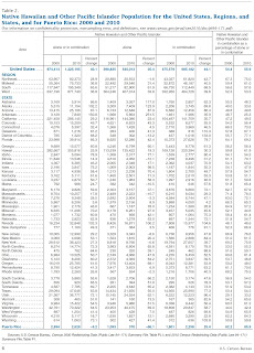
In the 2010 US Census, of all respondents who reported Native Hawaiian and Other Pacific Islander alone or in combination, 71-percent lived in the West, 16-percent lived in the South, 7-percent lived in the Northeast and 6-percent lived in the Midwest.

Hawaiʻi was home to 29% in the 2010 Census.  Over half (52 percent) of the Native Hawaiian and Other Pacific Islander alone or in combination population lived in just two states, Hawaii (356,000) and California (286,000.)

The image shows a chart of the distribution of Native Hawaiians as reported in the 2010 Census.  In addition, I have added additional images in a folder of like name in the Photos section on my Facebook and Google+ pages.

Follow Peter T Young on Facebook  

Follow Peter T Young on Google+  

© 2013 Hoʻokuleana LLC
Tuesday, August 13, 2013

Ala Moana Center


In ancient times, the area was known as Kālia – an ʻili in the ahupuaʻa of Waikīkī - that runs from the present Halekūlani Hotel to Piʻikoi Street (generally, makai of Kalākaua Avenue.)  Pi‘inaio Stream was the dominant feature of this eastern area of Waikīkī.

The ten fishponds at Kālia were loko puʻuone (isolated shore fishponds formed by a barrier sand berm) with salt-water lens intrusion and fresh water entering from upland ʻauwai (canals.)

Kālia was once renowned for the fragrant limu līpoa, as well as several other varieties of seaweed such as manauea, wāwaeʻiole, ʻeleʻele, kala and some kohu.

At the turn of the 20th century, portions of this marshy wetland were determined to be “deleterious to the public health in consequence of being low, and at times covered or partly covered by water, or of being situated between high and low water mark, or of being improperly drained, or incapable by reasonable expenditure of effectual drainage”.

A portion of this was owned by the Kamehameha Schools Bishop Estate who reportedly sold 50-acres of this “unproductive” “swamp land” for $25,000 to Walter F Dillingham in 1912.   At the time this was real money and people questioned his decision.

However, shortly thereafter, Dillingham used the site to dispose of excess coral and other fill that was generated from land reclamation projects from Kewalo to Waikīkī (including the dredging of the Ala Wai Canal.)

In 1948, Lowell Dillingham, Walter’s son, announced plans for a new shopping complex on the coral-covered parcel.  Nearly 10-years later, construction on Hawaiʻi’s first regional shopping center commenced.  (Lowell is also credited the formation of Dillingham Corporation, a merger of the Oahu Railway & Land Company and the Hawaiian Dredging and Construction Company, in 1961.)

Dillingham’s Don Graham was the force behind the design and development of the center.  It proved a success after its opening, and relocated retail away from downtown Honolulu.

On August 13, 1959, over a thousand people gathered near the Sears’ end for the grand opening of Ala Moana Center.  They say the first purchase in the center was made by Ben Dillingham and his wife, a tube of Colgate toothpaste at Sears

At the time of its opening, Ala Moana Center had 680,000-square feet of leasable area, with 87 stores on two levels and 4,000 parking spaces; and was considered the largest shopping mall in the world.  Original stores included anchors Sears and Shirokiya, plus locally-owned The Slipper House.

The center doubled in size in 1966 to 1,351,000-square feet of leasable area, with 155 stores and 7,800 parking spaces. New stores included anchor tenants JC Penney and Liberty House.

1987 saw the 2-year phase three renovation, relocation of certain tenants and creation of the Makai Market food court (the largest food court in Hawai‘i and one of the largest food courts in the nation.)

Other phases of expansion and renovation occurred over the years so that today, with 2.1-million square feet of retail space, Ala Moana Center has over 290 stores, including 70 dining options, nearly 10,000 parking spaces and is the world’s largest open-air mall – with shopping for the basics to the elite brand name.

Today, Ala Moana Center is one of the top grossing, highest occupancy rate and sales per square foot malls in the US and welcomes 40- to 60-million shopping visits per year.

Changes are again underway at Ala Moana, with redevelopment of the former Sears site to accommodate Bloomingdales and other shops - this will add another 340,000-SF of retail space and another 1,000-parking stalls.

Some of Ala Moana's original tenants are still in the shopping center: US Post Office, Territorial Savings Bank, Longs Drugs, Reyn's, Watamull's, Shirokiya and Foodland.

Oh, about Dillingham’s questioned $25,000 land buy back in 1912 … the City and County of Honolulu 2013 assessed value (for just the land) is $355,455,200.

(Dillingham Corporation was sold to a private investment group in 1983 for $347-million; in 2003, with base facilities relocated to California, Dillingham Corporation filed for bankruptcy.)

The image shows the vacant coral-filled site of the future Ala Moana Center.  In addition, I have added other images to a folder of like name in the Photos section on my Facebook and Google+ pages.

Follow Peter T Young on Facebook  

Follow Peter T Young on Google+  

© 2013 Hoʻokuleana LLC

Monday, August 12, 2013

ʻAwa


“ʻAwa was the food of the gods, just as poi was to the Hawaiians. No religious ceremony was complete without the ʻawa.”  (Pukui, Maly)

E hanai ʻawa a ikaika ka makani.
Feed with ʻawa so that the spirit may gain strength.
(One offers ʻawa and prayers to the dead so that their spirit may grow strong and be a source of help to the family.)

Outside of water and drinking coconut, no other drink was known.  ʻAwa was “a sacred drink of importance in many phases of Hawaiian life. … Its effect is to relax mind and body and it was used by farmer and fisherman for this purpose. Medicinal Kahunas (learned men) had many uses for it. It was essential on occasions of hospitality and feasting, and as a drink of pleasure for the chiefs.”  (Titcomb)

ʻAwa is a canoe crop, one of the plants brought by the earliest Polynesian voyagers arriving in Hawaiʻi. It is a member of the pepper family.  In other parts of the Pacific it is known as Kava or Kava Kava.  It is a shrub growing about four to eight feet high.

There are several native traditions regarding the origin of ʻawa in Hawaiʻi. Perhaps the most significant narratives describe ʻawa as having been brought to Hawaiʻi from Kahiki (the ancestral homelands) by the akua (gods) Kāne and Kanaloa.

These two akua Kāne, a Hawaiian god and ancestor of the chiefs and commoners, a god of sunlight, fresh water, verdant growth, and forests; and Kanaloa, a god of the ocean, marine life, healing, and a companion of Kāne - planted ʻawa at various localities throughout the islands. In places where no water could be found with which to prepare the ʻawa, Kāne even caused water to appear, thus forming many springs and streams in the islands.  (Maly)

In the discovery of Hawaiʻi by Hawaii-loa, ʻawa is noted in the find, “One time when they (Hawaii-Loa and his company) had thus been long out on the ocean, Makaliʻi, the principal navigator, said to Hawaii-Loa: ‘Let us steer the vessel in the direction of Iao, the Eastern Star, the discoverer of land … There is land to the eastward, and here is a red star ... to guide us ... So they steered straight onward and arrived at the easternmost island ... They went ashore and found the country fertile and pleasant, filled withʻ awa, coconut trees ... and Hawaii-Loa, the chief, called that land after his own name … (Fornander)

It is valued as an intoxicating drink and as a medicine. ʻAwa is also a sedative, used as a sacred plant for prayer, as well as appreciated for pleasure, especially in the south Pacific islands. It assists in opening communication channels with others and with the elements.

The drink is made from the root, which is woody, slightly spongy, toughish and roughly gnarled.  The root was scraped and washed, then reduced to small pieces.  It was then ready to chew (mama) and mix with water to make a cold water infusion. In later days, chewing was replaced by grinding or pounding.  (Titcomb)

It is prepared by pulverizing the root in a mortar; if it is the dry article of commerce it is kept sufficiently moist to prevent its scattering and forming dust. When well pulverized, water is mixed with the mash to bring it to a proper dilution, when it is strained.  (Emerson)

The favorite ʻawa strainer of the Hawaiians is made of the stem of the ahu-awa plant. The stem is split up and the fiber separated from the pulp by being combed between two sticks.  It is then taken up from the bowl and the dripping liquor wrung out of it. The bits of ʻawa root which were caught in it are shaken out and it is again used as a strainer, this time being formed into a kind of funnel, something like a bird's nest, through which the awa drink is poured into the separate cups of those who are to partake.  (Emerson)

An 1899 article on Molokaʻi Archaeology in the Evening Bulletin notes, “At Pakaikai is found a large stone lying by the bank of the stream, in which are dug four holes each eight inches in diameter and six inches deep.  They are finely polished inside. The holes dug in this large stone are claimed to have been used as awa cups (apu awa) for Kamehameha-ai-luau (a descendant of Kamehameha the Great.)”

“They were chiseled with stone implements by the ancients during the stone age of Hawaiʻi nei, a task which no native of the present generation will dare undertake.  Nearby is another hole dug in another rock and much larger and deeper than the four. This last one is said to be the kānoa ʻawa (or kā ʻawa, large bowl in which ʻawa is mixed and strained,) or place where awa is cleaned and purified, fit to drink.”

The beverage is not attractive to the eye. If dried ʻawa is used, the liquid is greyish, if green ʻawa is used it is greenish. The liquid is never clear in spite of straining. In Hawaiʻi it was a fairly thick liquid, this being preferred to “the dishwater drunk in the south” according to an old saying remembered by Kinney. Ellis termed it “like thick calcareous water.”  (Titcomb)

The ʻawa-drinking house was like a chief’s house, there must be no gaiety, no talking, no jollity, lest one vomit. The candlenut torch was the only thing one desired - one or two torches would produce warmth - then there was a sound in the ear like the chirping of land shells and of fiddles that teased the ear pleasantly, or like the roaring of the strong wind that changed to stillness. Such was the custom of the planter; he would sleep till morning and the pains and soreness would be gone.  (Kamakau, Titcomb)

Their general drink is water or the milk of the coconut, but all the chiefs use the ʻawa, and some of them to excess, as was very evident from their skins, which were rough and parched as can well be conceived, and their eyes red and inflamed.  (Kotzebue, Titcomb)

There is a deep cultural-historical relationship between the Hawaiians and ʻawa. The poʻe kahiko (ancient people) identified many varieties, cultivation techniques, values and uses of the ʻawa.  (Maly)

I have had ʻawa once, it was part of an ʻawa ceremony we participated in to commemorate the signing of the Kaʻawaloa Curator Agreement between DLNR and the Royal Order of Kamehameha I.  (It was a moving experience; I was proud and honored to be there.  The descendant families, members of the Order and others sat on one side; I sat by myself (representing the State) on the other side.)

The image shows the Kaʻawaloa ʻawa ceremony.  In addition, I have added related images in a folder of like name in the Photos section on my Facebook and Google+ pages.

Follow Peter T Young on Facebook  

Follow Peter T Young on Google+  

© 2013 Hoʻokuleana LLC

Sunday, August 11, 2013

Ala Hele Moʻolelo O Lāhainā


Maui captured “Best Island in the World” honors in the annual Conde Nast Traveler Readers’ Choice Awards Poll for nearly twenty-years in a row.  Readers rave about this “veritable paradise,” calling it a “combination of tropical ambience and American comforts.”

Maui is known for its beaches and water activities, and the west side, including Lāhainā, boasts some of the most beautiful shores in Hawaiʻi, and it also has the distinction of having some of the most beautiful sunset views on the planet.

Lāhainā is the second most visited place in Maui - (behind the beaches) - a combination of natural scenic beauty, white sandy beaches, lush green uplands, near-perfect weather, rich culture and a great Hawaiian history in its sunny shores.

From 700 AD to the present, Lāhainā’s Front Street has experienced six major historical eras, from its days as an ancient Hawaiian Royal Center, capital and home of the Hawaiian Monarchy, home to Missionaries, Landing/Provisioning for Whalers, the Sugar and Pineapple Plantation era and now Tourism.

All are still visible in town.

Lāhainā has played an important role in the history of Maui and the neighboring islands of Moloka‘i, Lānaʻi and Kahoʻolawe, with Lāhainā serving as the Royal Center, selected for its abundance of resources and recreation opportunities, with good surfing and canoe-landing sites.

Probably there is no portion of the Valley Isle, around which gathers so much historic value as Lāhainā. It was the former capital and favorite residence of kings and chiefs. After serving for centuries as home to ruling chiefs, Lāhainā was selected by Kamehameha III and his chiefs to be the capital and seat of government; here the first Hawaiian constitution was drafted and the first legislature was convened.

Hawai‘i’s whaling era began in 1819 when two New England ships became the first whaling ships to arrive in the Hawaiian Islands.   Over the next two decades, the Pacific whaling fleet nearly quadrupled in size and in the record year of 1846, 736-whaling ships arrived in Hawai'i.

Lāhainā was the port of choice for whaling ships.  Central  among the  islands,  Lāhainā was  a  convenient  spot from which  to  administer  the  affairs of  both  Hawaiian  and  foreigner.

The anchorage being an open roadstead, vessels can always approach or leave it with any wind that blows.  No pilot is needed here.  Vessels generally approach through the channel between Maui and Molokaʻi, standing well over to Lānaʻi, as far as the trade will carry them, then take the sea breeze, which sets in during the forenoon, and head for the town.

In November 1822, the 2nd Company from the ABCFM set sail on the 'Thames' from New Haven, Connecticut for the Hawaiian Islands; they arrived on April 23, 1823 (included in this Company were missionaries Charles Stewart, William Richards and Betsey Stockton – they were the first to settle and set up a mission in Lāhainā.)

The Christian religion really caught on when High Chiefess Keōpūolani (widow of Kamehameha I and mother of future kings) is said to have been the first convert of the missionaries in the islands, receiving baptism from Rev. William Ellis in Lāhainā on September 16, 1823.

In 1831, classes at the new Mission Seminary at Lahainaluna (later known as Lahainaluna (Upper Lāhainā)) began.  The school was established by the American Board of Commissioners of Foreign Missions “to instruct young men of piety and promising talents” (training preachers and teachers.)  It is the oldest high school west of the Mississippi River.

Per the requests of the chiefs, the American Protestant missionaries began teaching the makaʻāinana (commoners.)   Literacy levels exploded.  From 1820 to 1832, in which Hawaiian literacy grew by 91 percent, the literacy rate on the US continent grew by only 6 percent and did not exceed the 90 percent level until 1902 - three hundred years after the first settlers landed in Jamestown - overall European literacy rates in 1850 had not been much above 50 percent.

The early Polynesian settlers to Hawaiʻi brought sugar cane with them and demonstrated that it could be grown successfully.  It was not until ca. 1823 that several members of the Lāhainā Mission Station began to process sugar from native sugarcanes for their tables.  By the 1840s, efforts were underway in Lāhainā to develop a means for making sugar as a commodity.

Historically Maui’s second largest industry, pineapple cultivation has also played a large role in forming Maui’s modern day landscape.  The pineapple industry began on Maui in 1890 with Dwight D. Baldwin’s Haiku Fruit and Packing Company on the northeast side of the island.

Starting in the 1850s, when the Hawaiian Legislature passed "An Act for the Governance of Masters and Servants," a section of which provided the legal basis for contract-labor system, labor shortages were eased by bringing in contract workers from Asia, Europe and North America.

It is not likely anyone then foresaw the impact this would have on the cultural and social structure of the islands.  The sugar industry is at the center of Hawaiʻi's modern diversity of races and ethnic cultures.  Of the nearly 385,000 workers that came, many thousands stayed to become a part of Hawai‘i’s unique ethnic mix.   Hawai‘i continues to be one of the most culturally-diverse and racially-integrated places on the globe.

It is believed that Hawai‘i's first accommodations for transients were established sometime after 1810, when Don Francisco de Paula Marin “opened his home and table to visitors on a commercial basis .... (in) ‘guest houses’ (for) the ship captains who boarded with him while their vessels were in port (Honolulu.)”

Tourism exploded.  Steadily during the 1960s, 70s and 80s, the millions of tourists added up.  A new record number of visitor arrivals (over 7.8-million visitors) came to the islands in 2012. Tourism is the activity most responsible for Hawaiʻi’s current economic growth and standard of living.

By whatever means (vehicle, transit, bicycle or on foot,) exploring Lāhainā and embracing the scenic beauty, natural features, historic sites, associated cultural traditions and recreational opportunities will give the traveler a greater appreciation and understanding of Hawai‘i’s past and sense of place in the world – and demonstrates why Lāhainā is a “window to the world.”

To commemorate Lāhainā’s rich heritage, the Lāhainā Interpretive Plan Team has designed a series of interpretive signs and orientation maps called Ala Hele Moʻolelo O Lāhainā, the Lāhainā Historic Trail, which is now installed throughout Lāhainā’s two historic districts surrounding Front Street.  Lāhainā Restoration Foundation participated in this trail formation.

The historic “trail” is not really a trail, but rather identification of the historical sites scattered throughout Lāhainā.  Many have been restored by the Lāhainā Restoration Foundation, and can be found within the core of Lāhainā.

This self-guided walking tour provides a view of each era of the town that is considered one of the most historically significant places in Hawai'i.

Lāhainā is a place where history and culture come alive.

The image shows the Ala Hele Moʻolelo O Lāhainā, the Lāhainā Historic Trail.  In addition, I have added related images in a folder of like name in the Photos section on my Facebook and Google+ pages.

Follow Peter T Young on Facebook  

Follow Peter T Young on Google+  

© 2013 Hoʻokuleana LLC

Saturday, August 10, 2013

American Board of Commissioners for Foreign Missions (ABCFM)


There are three prominent names associated with the history of Missions in America, Eliot of the 17th century, Brainerd of the 18th century and Mills of the 19th century.

John Eliot (c. 1604 – 21 May 1690) was a Puritan missionary to the American Indians. His efforts earned him the designation “the apostle to the Indians.”

David Brainerd (April 20, 1718–October 9, 1747) was an American missionary to the Native Americans who had a ministry among the Delaware Indians of New Jersey.

Samuel John Mills (1783-1818) was the key instigator of American foreign missions. He grew up in Torringford, Connecticut, where his father, also named Samuel John Mills (1743-1833,) was pastor of the Congregational Church.

In the early-1800s, the US was swept by religious revivalism and many people were converted in the wake of the newly born religious fervor.  The Second Great Awakening spread from its origins in Connecticut to Williamstown, Massachusetts; enlightenment ideals from France were gradually being countered by an increase in religious fervor, first in the town, and then in Williams College.

In 1806, Mills headed off to Williams College in Massachusetts; he shared his thoughts on a missionary life with a few friends at college.

In the summer of 1806, in a grove of trees, in what was then known as Sloan's Meadow, Mills, James Richards, Francis L Robbins, Harvey Loomis and Byram Green debated the theology of missionary service.  Their meeting was interrupted by a thunderstorm and they took shelter under a haystack until the sky cleared.

That event has since been referred to as the “Haystack Prayer Meeting” and is viewed by many scholars as the pivotal event for the development of Protestant missions in the subsequent decades and century.

The first American student missionary society began in September 1808, when Mills and others called themselves "The Brethren," whose object was "to effect, in the person of its members, a mission or missions to the heathen."  (Smith)  Mill graduated Williams College in 1809 and later Andover Theological Seminary.

In June 1810, Mills and James Richards petitioned the General Association of the Congregational Church to establish the foreign missions.  American Board of Commissioners for Foreign Missions was formed with a Board of members from Massachusetts and Connecticut.

In February, 1812, Rev. and Mrs. Judson, Rev. and Mrs. Newall, Rev. and Mrs. Nott, Rev. Gordon Hall and Rev. Luther Rice were commissioned as the Board's first missionaries and set sail for Calcutta, India. (williams-edu)

In 1818, following a brief stay in England, Mills sailed to the west coast of Africa to purchase land for the American Colonization Society, then embarked for the United States on May 22 - he died at sea on June 16, 1818.

The story of the Foreign Mission School (1817-1826) connects the town of Cornwall, Connecticut, to a larger, national religious fervor of the Second Great Awakening. Cornwall’s Foreign Mission School exemplified evangelical efforts to recruit young men from indigenous cultures around the world, convert them to Christianity, educate them, and train them to become preachers, health workers, translators and teachers back in their native lands.

The school’s first student was Henry ʻŌpūkahaʻia (Obookiah,) a native Hawaiian from the Island of Hawaiʻi who in 1809 (at the age of 16, after his parents had been killed) boarded a sailing ship anchored in Kealakekua Bay and sailed to the continent.   In its first year, the Foreign Mission School had 12 students, more than half of whom were Hawaiian.

The next year, the enrollment doubled to 24 and, in addition to Chinese, Hindu and Bengali students, also consisted of seven Native Americans of Choctaw, Abnaki and Cherokee descent. By 1820, Native Americans from six different tribes made up half of the school’s students.

Once enrolled, students spent seven hours a day in study. Subjects included chemistry, geography, calculus and theology, as well as Greek, French and Latin. They were also taught special skills like coopering (the making of barrels and other storage casks), blacksmithing, navigation and surveying. When not in class, students attended mandatory church and prayer sessions and also worked on making improvements to the school’s lands.

ʻŌpūkahaʻia died suddenly of typhus fever in 1818; the “Memoirs of Henry Obookiah” served as an inspiration for missionaries to volunteer to carry his message to the Sandwich Islands.

On October 23, 1819, a group of northeast missionaries, led by Hiram Bingham, set sail on the Thaddeus for the Sandwich Islands (now known as Hawai‘i.)  With the missionaries were four Hawaiian students from the Foreign Mission School, Thomas Hopu, William Kanui, John Honoliʻi and Prince Humehume (son of Kauaʻi’s King Kaumuali‘i.)

The Prudential Committee of the ABCFM in giving instructions to the pioneers of 1819 said: “Your mission is a mission of mercy, and your work is to be wholly a labor of love. … Your views are not to be limited to a low, narrow scale, but you are to open your hearts wide, and set your marks high. You are to aim at nothing short of covering these islands with fruitful fields, and pleasant dwellings and schools and churches, and of Christian civilization.”  (The Friend)

Over the course of a little over 40-years (1820-1863) (the “Missionary Period”,) about 180-men and women in twelve Companies served in Hawaiʻi to carry out the mission of the ABCFM in the Hawaiian Islands.

Today, the Hawaiian Mission Children's Society, a nonprofit educational institution and genealogical society, exists to promote an understanding of the social history of nineteenth-century Hawai‘i and its critical role in the formation of modern Hawai‘i.

The Society operates the Hawaiian Mission Houses Historic Site and Archives, comprised of three historic buildings and a research archives with reading room. The Society also compiles the genealogical records of the American Protestant missionaries in Hawai‘i and promotes the participation of missionary descendants in the Society's activities.

Through the Site and Archives, the Society collects and preserves the documents, artifacts and other records of the missionaries in Hawai‘i's history; makes these collections available for research and educational purposes; and interprets the historic site and collections to reflect the social history of nineteenth century Hawai‘i and America.

The image shows the Foreign Mission School in Cornwall, Connecticut.    In addition, I have added other related images in a folder of like name in the Photos section on my Facebook and Google+ pages.

Follow Peter T Young on Facebook  

Follow Peter T Young on Google+  

© 2013 Hoʻokuleana LLC